Quick Summary:

This paper introduces a novel path planning method for multi-level terrains, utilizing a multi-level skip-list structure for point cloud map simplification and a weighted traversability graph for efficient path generation. The A* algorithm is adapted to leverage the traversability graph, demonstrating effectiveness in diverse environments.

Summary

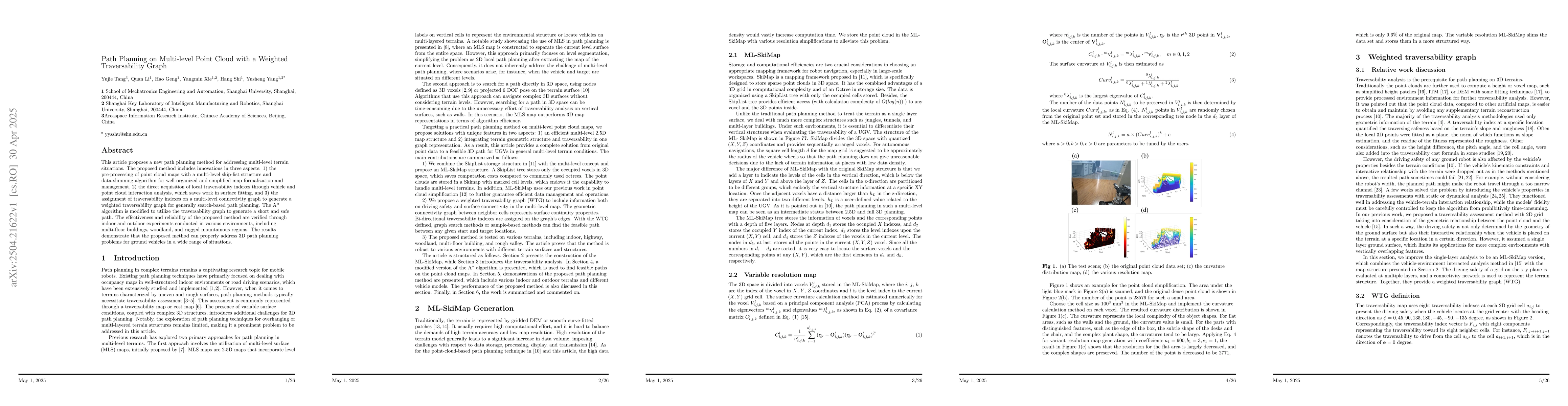
This article proposes a new path planning method for addressing multi-level terrain situations. The proposed method includes innovations in three aspects: 1) the pre-processing of point cloud maps with a multi-level skip-list structure and data-slimming algorithm for well-organized and simplified map formalization and management, 2) the direct acquisition of local traversability indexes through vehicle and point cloud interaction analysis, which saves work in surface fitting, and 3) the assignment of traversability indexes on a multi-level connectivity graph to generate a weighted traversability graph for generally search-based path planning. The A* algorithm is modified to utilize the traversability graph to generate a short and safe path. The effectiveness and reliability of the proposed method are verified through indoor and outdoor experiments conducted in various environments, including multi-floor buildings, woodland, and rugged mountainous regions. The results demonstrate that the proposed method can properly address 3D path planning problems for ground vehicles in a wide range of situations.

AI Key Findings

Generated Jun 08, 2025

Methodology

The methodology involves pre-processing point cloud maps with a multi-level skip-list structure and data-slimming algorithm, acquiring local traversability indexes through vehicle and point cloud interaction analysis, and assigning these indexes on a multi-level connectivity graph to generate a weighted traversability graph for path planning using a modified A* algorithm.

Key Results

  • Proposed method effectively addresses 3D path planning problems for ground vehicles in diverse environments including multi-floor buildings, woodland, and mountainous regions.
  • The approach simplifies map formalization and management, saves computational work by directly acquiring traversability indexes, and generates safe and short paths via a modified A* algorithm utilizing the traversability graph.

Significance

This research is significant as it presents a robust path planning method for multi-level terrains, which can be applied in various real-world scenarios such as autonomous navigation in complex indoor/outdoor environments, thereby enhancing the reliability and efficiency of ground vehicles.

Technical Contribution

The main technical contribution lies in the innovative pre-processing of point cloud maps, direct acquisition of traversability indexes, and the creation of a weighted traversability graph for path planning, all tailored for multi-level terrain situations.

Novelty

This work stands out due to its comprehensive approach that combines efficient point cloud management, direct traversability index acquisition, and a modified A* algorithm for path planning in multi-level environments, which is distinct from existing methods that often rely on surface fitting or simpler terrain representations.

Limitations

  • The paper does not explicitly discuss limitations, but potential limitations could include the computational resources required for processing point cloud data and the algorithm's performance in highly dynamic environments.

Future Work

  • Further research could focus on optimizing the data-slimming algorithm for real-time applications and adapting the method to more complex, rapidly changing environments.
  • Investigating the integration of additional sensor data for improved traversability index calculation.

Paper Details

PDF Preview

Download PDF

Key Terms

No key terms available for this paper.

Citation Network

Current paper (gray), citations (green), references (blue)

Current Paper
Citations
References
Click to view

No citations found for this paper.

Comments (0)

This website uses cookies to ensure you get the best experience. Learn more