Performance Evaluation of GPS Trajectory Rasterization Methods
Publication
Metrics
AI Quick Summary
This paper evaluates four methods for rasterizing GPS trajectory data: QGIS, PostGIS+QGIS, an iterative spatial grid aggregation in Python, and a parallelized version of the latter. Results show that the Python-based methods outperform QGIS and PostGIS+QGIS in terms of processing time, while the parallelized version scales well with more processors.
Paper Preview
Abstract
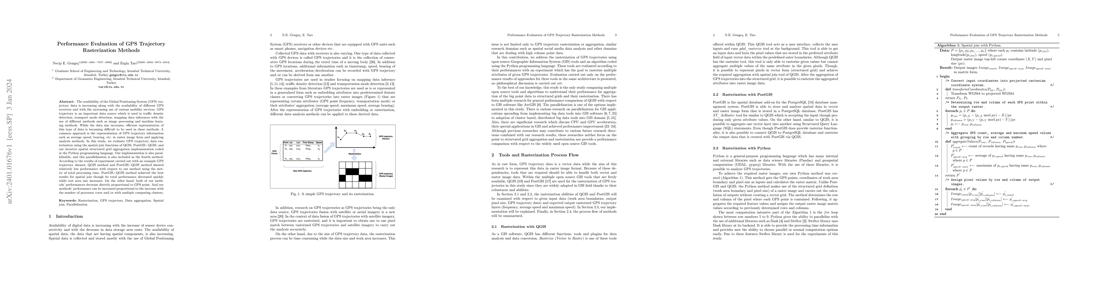
The availability of the Global Positioning System (GPS) trajectory data is increasing along with the availability of different GPS receivers and with the increasing use of various mobility services. GPS trajectory is an important data source which is used in traffic density detection, transport mode detection, mapping data inferences with the use of different methods such as image processing and machine learning methods. While the data size increases, efficient representation of this type of data is becoming difficult to be used in these methods. A common approach is the representation of GPS trajectory information such as average speed, bearing, etc. in raster image form and applying analysis methods. In this study, we evaluate GPS trajectory data rasterization using the spatial join functions of QGIS, PostGIS+QGIS, and our iterative spatial structured grid aggregation implementation coded in the Python programming language. Our implementation is also parallelizable, and this parallelization is also included as the fourth method. According to the results of experiment carried out with an example GPS trajectory dataset, QGIS method and PostGIS+QGIS method showed relatively low performance with respect to our method using the metric of total processing time. PostGIS+QGIS method achieved the best results for spatial join though its total performance decreased quickly while test area size increases. On the other hand, both of our methods' performances decrease directly proportional to GPS point. And our methods' performance can be increased proportional to the increase with the number of processor cores and/or with multiple computing clusters.
AI Key Findings
Get AI-generated insights about this paper's methodology, results, significance, and more — seven facets brought into focus.
Impact
Paper Details
Authors
PDF Preview
Key Terms
Citation Network
Current paper (gray), citations (green), references (blue)
Display is limited for performance on very large graphs.
Discussion 0