Quick Summary:

This paper presents a technique to automatically generate realistic 3D scenes from satellite imagery, enabling simulations with increased fidelity and reduced manual intervention. It uses physics-driven simulation to model scene geometry, material estimates, and dynamic elements, paving the way for algorithm development and processing pipelines for various types of imagery.

Summary

Physics driven image simulation allows for the modeling and creation of realistic imagery beyond what is afforded by typical rendering pipelines. We aim to automatically generate a physically realistic scene for simulation of a given region using satellite imagery to model the scene geometry, drive material estimates, and populate the scene with dynamic elements. We present automated techniques to utilize satellite imagery throughout the simulated scene to expedite scene construction and decrease manual overhead. Our technique does not use lidar, enabling simulations that could not be constructed previously. To develop a 3D scene, we model the various components of the real location, addressing the terrain, modelling man-made structures, and populating the scene with smaller elements such as vegetation and vehicles. To create the scene we begin with a Digital Surface Model, which serves as the basis for scene geometry, and allows us to reason about the real location in a common 3D frame of reference. These simulated scenes can provide increased fidelity with less manual intervention for novel locations on earth, and can facilitate algorithm development, and processing pipelines for imagery ranging from UV to LWIR $(200nm-20\mu m)$.
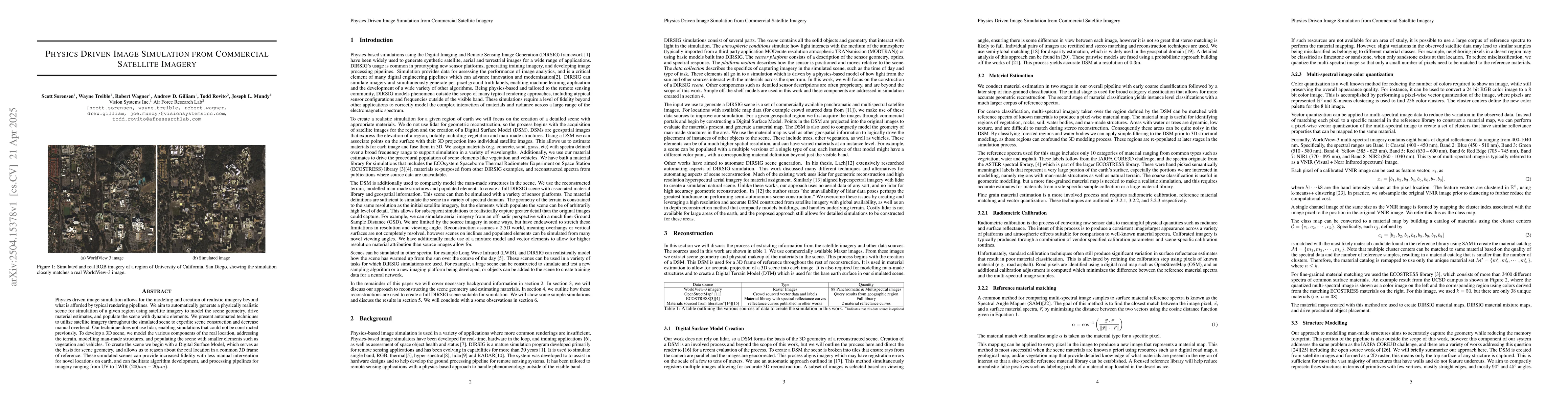
AI Key Findings

Generated Jun 09, 2025

Methodology

The research utilizes physics-driven image simulation from commercial satellite imagery to model and create realistic imagery, automating scene construction with satellite imagery for geometry, material estimates, and dynamic elements, without relying on LiDAR.

Key Results

  • Automated techniques to use satellite imagery for scene construction, reducing manual overhead and enabling simulations for locations previously inaccessible.
  • Creation of 3D scenes with terrain, man-made structures, and smaller elements like vegetation and vehicles, using Digital Surface Model (DSM) as the basis for scene geometry.
  • Development of Digital Terrain Model (DTM) to separate terrain from other elements, ensuring smooth surface approximation without modeling vegetation or man-made structures' elevations.
  • Procedural element population for densely populating forested areas and diverse vehicle instances with few base models.
  • Material reconstruction, translation, and remapping techniques for applying materials to the DIRSIG scene, including direct translation, material remapping, and creation of material mixture maps.

Significance

This research significantly contributes to the field by providing a method to generate high-fidelity, physics-driven simulations for novel locations on Earth, facilitating algorithm development and processing pipelines for various wavelengths of imagery.

Technical Contribution

The paper presents automated techniques for physics-driven image simulation using commercial satellite imagery, including methods for terrain and structure modeling, material classification, and procedural element population.

Novelty

The research distinguishes itself by not using LiDAR data, enabling simulations for virtually any location on Earth with reduced manual overhead, and by combining various spectral libraries with custom tools to create rich material definitions for scene elements.

Limitations

  • The approach may suffer from geometric errors due to failures in reconstruction, especially in dynamic real-world scenes with construction or renovation projects.
  • Material estimates are limited by available observations and material libraries, potentially missing subtle spectral variations outside the visible spectrum.
  • Populate elements rely on labeling, which can be inaccurate or incomplete in crowdsourced datasets like OpenStreetMap.

Future Work

  • Explore advanced techniques to mitigate geometric errors caused by dynamic scenes and improve material estimation accuracy.
  • Investigate methods to better capture and simulate materials outside the visible spectrum, considering pigments, dyes, and paints that alter color without affecting reflectance in other bands.
  • Develop strategies to handle mislabeled or missing data in crowdsourced geospatial datasets for more accurate scene construction.

Paper Details

PDF Preview

Download PDF

Key Terms

No key terms available for this paper.

Citation Network

Current paper (gray), citations (green), references (blue)

Current Paper
Citations
References
Click to view

No citations found for this paper.

Comments (0)

This website uses cookies to ensure you get the best experience. Learn more