PillarSegNet: Pillar-based Semantic Grid Map Estimation using Sparse LiDAR Data
Publication
Metrics
AI Quick Summary
PillarSegNet proposes a novel method for generating dense semantic grid maps from sparse LiDAR data using PointNet for feature learning and 2D semantic segmentation in the top view. This approach outperforms existing grid map methods by achieving a 10% improvement in mean Intersection over Union (mIoU) on the SemanticKITTI dataset.
Paper Preview
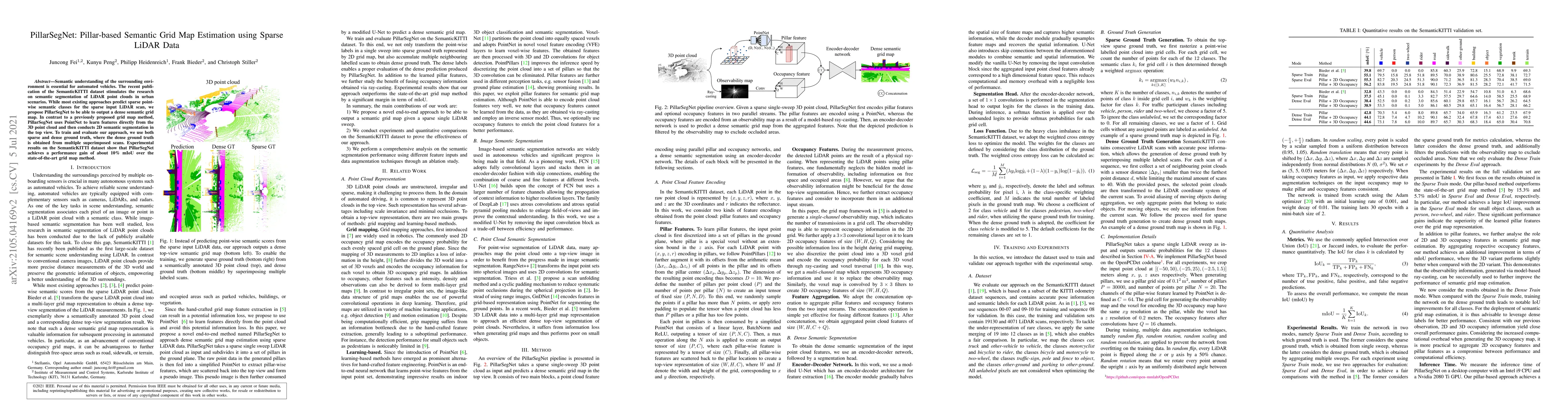
Abstract
Semantic understanding of the surrounding environment is essential for automated vehicles. The recent publication of the SemanticKITTI dataset stimulates the research on semantic segmentation of LiDAR point clouds in urban scenarios. While most existing approaches predict sparse pointwise semantic classes for the sparse input LiDAR scan, we propose PillarSegNet to be able to output a dense semantic grid map. In contrast to a previously proposed grid map method, PillarSegNet uses PointNet to learn features directly from the 3D point cloud and then conducts 2D semantic segmentation in the top view. To train and evaluate our approach, we use both sparse and dense ground truth, where the dense ground truth is obtained from multiple superimposed scans. Experimental results on the SemanticKITTI dataset show that PillarSegNet achieves a performance gain of about 10% mIoU over the state-of-the-art grid map method.
AI Key Findings
Get AI-generated insights about this paper's methodology, results, significance, and more — seven facets brought into focus.
Impact
Paper Details
PDF Preview
Key Terms
Citation Network
Current paper (gray), citations (green), references (blue)
Display is limited for performance on very large graphs.
Discussion 0