Quick Summary:

Researchers created a geologic map of Pluto using crater data to understand age relationships, revealing young terrains with varying morphologies and large areas of crater-free regions.

Summary

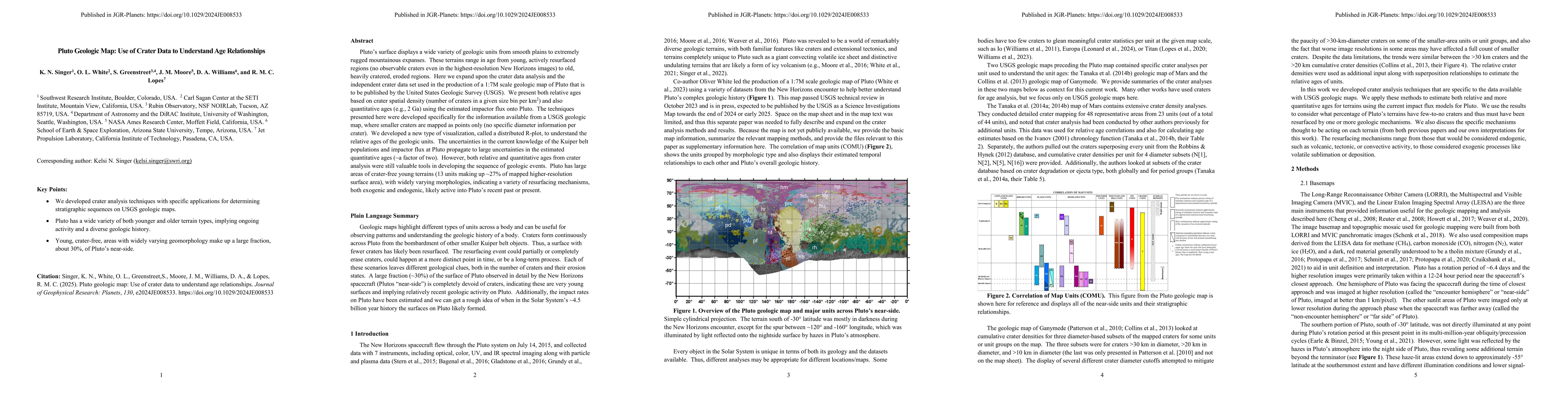
Pluto's surface displays a wide variety of geologic units from smooth plains to extremely rugged mountainous expanses. These terrains range in age from young, actively resurfaced regions (no observable craters even in the highest-resolution New Horizons images) to old, heavily cratered, eroded regions. Here we expand upon the crater data analysis and the independent crater data set used in the production of a 1:7M scale geologic map of Pluto that is to be published by the United States Geologic Survey (USGS). We present both relative ages based on crater spatial density (number of craters in a given size bin per km^2) and also quantitative ages (e.g., 2 Ga) using the estimated impactor flux onto Pluto. The techniques presented here were developed specifically for the information available from a USGS geologic map, where smaller craters are mapped as points only (no specific diameter information per crater). We developed a new type of visualization, called a distributed R-plot, to understand the relative ages of the geologic units. The uncertainties in the current knowledge of the Kuiper belt populations and impactor flux at Pluto propagate to large uncertainties in the estimated quantitative ages (~a factor of two). However, both relative and quantitative ages from crater analysis were still valuable tools in developing the sequence of geologic events. Pluto has large areas of crater-free young terrains (13 units making up ~27% of mapped higher-resolution surface area), with widely varying morphologies, indicating a variety of resurfacing mechanisms, both exogenic and endogenic, likely active into Pluto's recent past or present.

AI Key Findings

Generated Jun 08, 2025

Methodology

The research utilizes crater data analysis and an independent crater data set to create a 1:7M scale geologic map of Pluto, employing relative and quantitative ages derived from crater spatial density and impactor flux estimates.

Key Results

  • Pluto's surface displays a variety of geologic units ranging in age from young, resurfaced regions to old, heavily cratered terrains.
  • 13 geologic units, representing ~27% of higher-resolution surface area, are crater-free, indicating diverse resurfacing mechanisms active in Pluto's recent past or present.
  • A new visualization technique, distributed R-plot, was developed to understand relative ages of geologic units.

Significance

This research is crucial for understanding Pluto's geologic history and the processes that have shaped its surface, contributing to our knowledge of Kuiper Belt objects and planetary evolution.

Technical Contribution

Development of distributed R-plot visualization technique for understanding relative ages of geologic units from crater data.

Novelty

This work presents a comprehensive geologic map of Pluto using crater data analysis, incorporating both relative and quantitative ages, despite significant uncertainties in impactor flux estimates.

Limitations

  • Large uncertainties (~factor of two) in quantitative ages due to limited knowledge of Kuiper belt populations and impactor flux at Pluto.
  • Smaller craters are mapped as points only, lacking specific diameter information per crater

Future Work

  • Further study of Pluto's geologic units and resurfacing mechanisms.
  • Improving crater size and population data for more accurate age estimations

Paper Details

PDF Preview

Download PDF

Key Terms

No key terms available for this paper.

No citations found for this paper.

Comments (0)

This website uses cookies to ensure you get the best experience. Learn more