Summary

Driven by the growing need for Oriented Object Detection (OOD), learning from point annotations under a weakly-supervised framework has emerged as a promising alternative to costly and laborious manual labeling. In this paper, we discuss two deficiencies in existing point-supervised methods: inefficient utilization and poor quality of pseudo labels. Therefore, we present Point2RBox-v3. At the core are two principles: 1) Progressive Label Assignment (PLA). It dynamically estimates instance sizes in a coarse yet intelligent manner at different stages of the training process, enabling the use of label assignment methods. 2) Prior-Guided Dynamic Mask Loss (PGDM-Loss). It is an enhancement of the Voronoi Watershed Loss from Point2RBox-v2, which overcomes the shortcomings of Watershed in its poor performance in sparse scenes and SAM's poor performance in dense scenes. To our knowledge, Point2RBox-v3 is the first model to employ dynamic pseudo labels for label assignment, and it creatively complements the advantages of SAM model with the watershed algorithm, which achieves excellent performance in both sparse and dense scenes. Our solution gives competitive performance, especially in scenarios with large variations in object size or sparse object occurrences: 66.09%/56.86%/41.28%/46.40%/19.60%/45.96% on DOTA-v1.0/DOTA-v1.5/DOTA-v2.0/DIOR/STAR/RSAR.
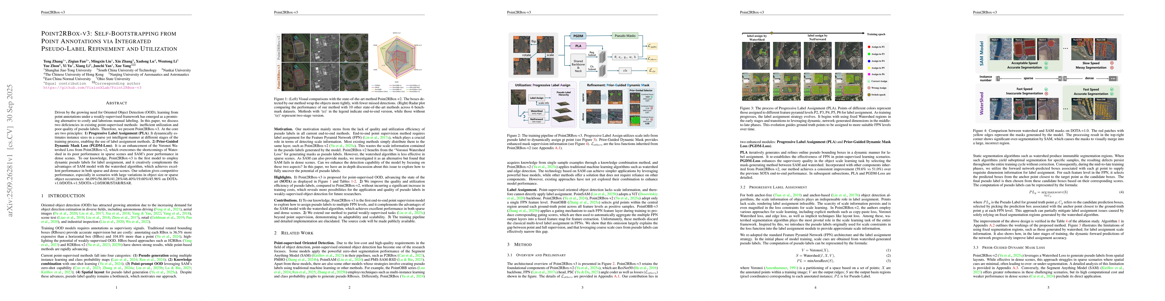
AI Key Findings

Generated Oct 01, 2025

Methodology

The research employs a hybrid approach combining Voronoi Watershed segmentation with Segment Anything Model (SAM) for instance segmentation, enhanced by Progressive Label Assignment (PLA) and Gaussian Overlap Loss for robust object detection in remote sensing scenes.

Key Results

  • Achieved state-of-the-art performance on DOTA, DIOR, STAR, and RSAR datasets with significant improvements in overlapping object segmentation
  • Class-specific Watershed algorithm outperformed standard Watershed by 1.45% in mask quality for challenging overlapping instances
  • Copy-paste augmentation and self-supervised consistency loss enhanced model robustness across diverse spatial layouts

Significance

This work advances remote sensing object detection by addressing critical challenges in sparse and overlapping scenarios, enabling more accurate and reliable analysis of aerial imagery for applications like urban planning and disaster response.

Technical Contribution

Proposed a novel integration of Voronoi Watershed with SAM, combined with PLA and specialized loss functions, creating a robust framework for instance segmentation in remote sensing with improved handling of overlapping and sparse objects.

Novelty

Introduces class-specific Watershed for targeted segmentation, progressive label assignment for dynamic training adaptation, and a comprehensive set of spatial-aware loss functions that collectively address limitations in existing methods for remote sensing object detection.

Limitations

  • Performance gains from PLA are less pronounced in uniformly scaled datasets
  • SAM's sensitivity to color limits effectiveness in sparse instances with unclear boundaries

Future Work

  • Enhance SAM prompts with edge-aware algorithms for better sparse instance segmentation
  • Explore holistic architectural upgrades and innovative loss functions for improved learning signals
  • Investigate multi-modal fusion with satellite imagery and LiDAR data for enhanced context understanding

Paper Details

PDF Preview

Download PDF

Comments (0)

This website uses cookies to ensure you get the best experience. Learn more