This paper proposes a novel method for estimating socioeconomic indicators in developing countries using geolocated Wikipedia articles and NLP techniques, showing that it can predict community-level asset wealth and education outcomes. When combined with satellite imagery, the method outperforms existing benchmarks, highlighting Wikipedia's potential to inform social science research and policy decisions.
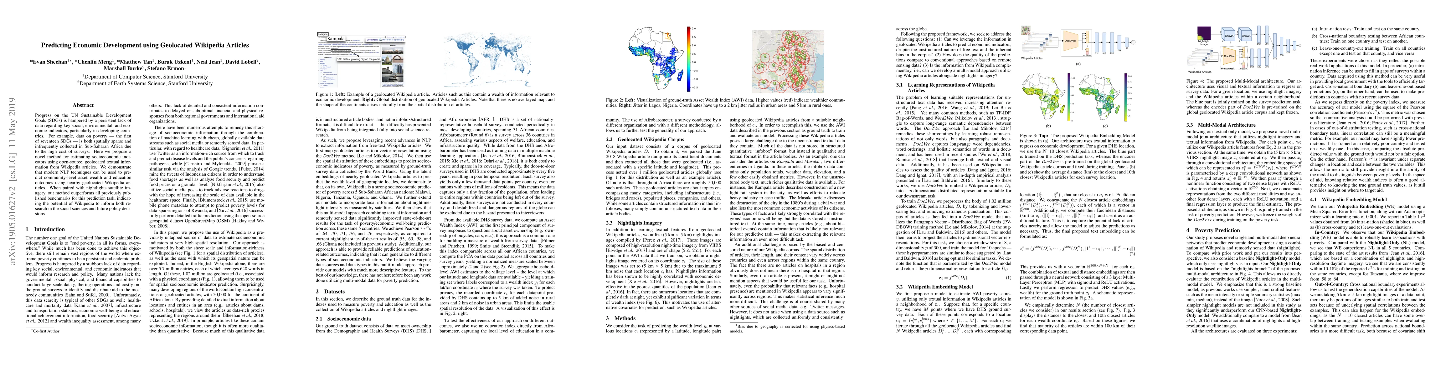
Progress on the UN Sustainable Development Goals (SDGs) is hampered by a persistent lack of data regarding key social, environmental, and economic indicators, particularly in developing countries. For example, data on poverty --- the first of seventeen SDGs --- is both spatially sparse and infrequently collected in Sub-Saharan Africa due to the high cost of surveys. Here we propose a novel method for estimating socioeconomic indicators using open-source, geolocated textual information from Wikipedia articles. We demonstrate that modern NLP techniques can be used to predict community-level asset wealth and education outcomes using nearby geolocated Wikipedia articles. When paired with nightlights satellite imagery, our method outperforms all previously published benchmarks for this prediction task, indicating the potential of Wikipedia to inform both research in the social sciences and future policy decisions.
Get AI-generated insights about this paper's methodology, results, and significance.
Current paper (gray), citations (green), references (blue)
Luis Espinosa-Anke, Hsuvas Borkakoty
Title | Authors | Year | Actions |
---|---|---|---|
Estimating impact with surveys versus digital traces: Evidence from randomized cash transfers in Togo
|
Emily L. Aiken, Suzanne Bellue, Joshua E. Blumenstock, Dean Karlan, Christopher Udry
|
2025
|
View Paper |
Geolocation Representation from Large Language Models are Generic Enhancers for Spatio-Temporal Learning
|
Junlin He, Tong Nie, Wei Ma
|
2024
|
View Paper |
High-Resolution Income Estimates Using Satellite Imagery: A Deep Learning Approach Applied in Buenos Aires
|
Nicolás F. Abbate, Leonardo Gasparini, Franco Ronchetti, F. Quiroga
|
2024
|
View Paper |
High-resolution comprehensive regional development mapping using multisource geographic data
|
Linxin Li, Ting Hu, Guangyi Yang, Wei He, Hongyan Zhang
|
2024
|
View Paper |
GeoSEE: Regional Socio-Economic Estimation With a Large Language Model
|
Sungwon Han, Donghyun Ahn, Seungeon Lee, Min-Chae Song, Sungwon Park, Sangyoon Park, Jihee Kim, Meeyoung Cha
|
2024
|
View Paper |
Throw Your Hat in the Ring (of Wikipedia): Exploring Urban-Rural Disparities in Local Politicians' Information Supply
|
Akira Matsui, Kunihiro Miyazaki, Taichi Murayama
|
2024
|
View Paper |
Exploring the Role of Deep Learning in Forecasting for Sustainable Development Goals: A Systematic Literature Review
|
Agung Bella Putra Utama, A. Wibawa, A. N. Handayani, M. Chuttur
|
2024
|
View Paper |
Am I hurt?: Evaluating Psychological Pain Detection in Hindi Text using Transformer-based Models
|
Ravleen Kaur, M. Bhatia, Akshi Kumar
|
2024
|
View Paper |
Spatiotemporal self-supervised pre-training on satellite imagery improves food insecurity prediction
|
Ruben Cartuyvels, Tom Fierens, Emiel Coppieters, Marie-Francine Moens, Damien Sileo
|
2023
|
View Paper |
Explainability of Automated Fact Verification Systems: A Comprehensive Review
|
Manju Vallayil, P. Nand, W. Yan, Héctor Allende-Cid
|
2023
|
View Paper |
GeoVeX: Geospatial Vectors with Hexagonal Convolutional Autoencoders
|
Daniele Donghi, Anne Morvan
|
2023
|
View Paper |
A human-machine collaborative approach measures economic development using satellite imagery
|
Donghyun Ahn, Jeasurk Yang, Meeyoung Cha, Hyunjoo Yang, Jihee Kim, Sangyoon Park, Sungwon Han, Eunji Lee, Susang Lee, Sungwon Park
|
2023
|
View Paper |
GeoLLM: Extracting Geospatial Knowledge from Large Language Models
|
Rohin Manvi, Samar Khanna, Gengchen Mai, Marshall Burke, David B. Lobell, Stefano Ermon
|
2023
|
View Paper |
Estimating Impact with Surveys versus Digital Traces: Evidence from Randomized Cash Transfers in Togo∗
|
Emily L. Aiken, Suzanne Bellue, J. Blumenstock, Dean S. Karlan, Christopher Udry
|
2023
|
View Paper |
HindiPersonalityNet: Personality Detection in Hindi Conversational Data using Deep Learning with Static Embedding
|
Akshi Kumar, Dipika Jain, Rohit Beniwal
|
2023
|
View Paper |
HIEF: a holistic interpretability and explainability framework
|
Jan-Peter Kucklick
|
2023
|
View Paper |
Predicting Multidimensional Poverty with Machine Learning Algorithms: An Open Data Source Approach Using Spatial Data
|
Guberney Muñetón-Santa, Luis Carlos Manrique-Ruiz
|
2023
|
View Paper |
Learning and Reasoning Multifaceted and Longitudinal Data for Poverty Estimates and Livelihood Capabilities of Lagged Regions in Rural India
|
Atharva Kulkarni, Raya Das, R. Srivastava, Tanmoy Chakraborty
|
2023
|
View Paper |
Understanding economic development in rural Africa using satellite imagery, building footprints and deep models
|
Amna Elmustafa, Erik Rozi, Yutong He, Gengchen Mai, Stefano Ermon, M. Burke, D. Lobell
|
2022
|
View Paper |
Farm Parcel Extraction in Remote-Sensing Images Based on Semantic Segmentation
|
Yirong Wang, Liang Qi, Bangyu Li
|
2022
|
View Paper |
Tackling the Accuracy-Interpretability Trade-off: Interpretable Deep Learning Models for Satellite Image-based Real Estate Appraisal
|
Jan-Peter Kucklick, Oliver Müller
|
2022
|
View Paper |
Multimodal contrastive learning for remote sensing tasks
|
Umang Jain, Alex Wilson, Varun Gulshan
|
2022
|
View Paper |
Machine learning can guide food security efforts when primary data are not available
|
Giulia Martini, A. Bracci, Lorenzo Riches, Sejal Jaiswal, Matteo Corea, J. Rivers, A. Husain, E. Omodei
|
2022
|
View Paper |
SatMAE: Pre-training Transformers for Temporal and Multi-Spectral Satellite Imagery
|
Yezhen Cong, Samarth Khanna, Chenlin Meng, Patrick Liu, Erik Rozi, Yutong He, M. Burke, D. Lobell, Stefano Ermon
|
2022
|
View Paper |
Program Targeting with Machine Learning and Mobile Phone Data: Evidence from an Anti-Poverty Intervention in Afghanistan
|
Emily L. Aiken, Guadalupe Bedoya, J. Blumenstock, Aidan Coville
|
2022
|
View Paper |
Urban neighborhood socioeconomic status (SES) inference: A machine learning approach based on semantic and sentimental analysis of online housing advertisements
|
Lingqi Wang, Shenjing He, Shiliang Su, Yu Li, Lirong Hu, Guie Li
|
2022
|
View Paper |
Artificial intelligence for climate change adaptation
|
S. Cheong, K. Sankaran, Hamsa Bastani
|
2022
|
View Paper |
Worldwide city transport typology prediction with sentence-BERT based supervised learning via Wikipedia
|
Srushti Rath, Joseph Y. J. Chow
|
2022
|
View Paper |
Classification of Poverty Condition Using Natural Language Processing
|
Guberney Muñetón-Santa, D. Escobar-Grisales, F. O. López-Pabón, P. A. Pérez-Toro, J. Orozco-Arroyave
|
2022
|
View Paper |
IS-COUNT: Large-scale Object Counting from Satellite Images with Covariate-based Importance Sampling
|
Chenlin Meng, Enci Liu, W. Neiswanger, Jiaming Song, M. Burke, D. Lobell, Stefano Ermon
|
2021
|
View Paper |
SustainBench: Benchmarks for Monitoring the Sustainable Development Goals with Machine Learning
|
Christopher Yeh, Chenlin Meng, Sherrie Wang, Anne Driscoll, Erik Rozi, Patrick Liu, Jihyeon Lee, M. Burke, D. Lobell, Stefano Ermon
|
2021
|
View Paper |
The Wikipedia Diversity Observatory: helping communities to bridge content gaps through interactive interfaces
|
Marc Miquel-Ribé, David Laniado
|
2021
|
View Paper |
Twice Is Nice: The Benefits of Two Ground Measures for Evaluating the Accuracy of Satellite-Based Sustainability Estimates
|
D. Lobell, S. D. Tommaso, M. Burke, Talip Kilic
|
2021
|
View Paper |
How can new technology support better measurement of extreme poverty?
|
N. Tzavidis, Angela Luna Hernandez, P. Jasper, Molly M. Scott
|
2021
|
View Paper |
Exploring the Scope of Using News Articles to Understand Development Patterns of Districts in India
|
M. Gupta, Shayan Saifi, Konark Verma, K. Rekha, Aaditeshwar Seth
|
2021
|
View Paper |
Nowcasting food insecurity on a global scale
|
G. Martini, A. Bracci, S. Jaiswal, M. Corea, L. Riches, J. Rivers, E. Omodei
|
2021
|
View Paper |
Big Data and the United Nations Sustainable Development Goals (UN SDGs) at a Glance
|
Hossein Hassani, Xu Huang, S. MacFeely, Mohammad Reza Entezarian
|
2021
|
View Paper |
A review of scientific advancements in datasets derived from big data for monitoring the Sustainable Development Goals
|
Cameron Allen, M. Smith, M. Rabiee, H. Dahmm
|
2021
|
View Paper |
How Good Is NLP? A Sober Look at NLP Tasks through the Lens of Social Impact
|
Zhijing Jin, Geeticka Chauhan, Brian Tse, Mrinmaya Sachan, Rada Mihalcea
|
2021
|
View Paper |
Predicting Livelihood Indicators from Community-Generated Street-Level Imagery
|
Jihyeon Lee, Dylan Grosz, Burak Uzkent, Sicheng Zeng, M. Burke, D. Lobell, Stefano Ermon
|
2021
|
View Paper |
Efficient Poverty Mapping from High Resolution Remote Sensing Images
|
Kumar Ayush, Burak Uzkent, K. Tanmay, M. Burke, D. Lobell, Stefano Ermon
|
2021
|
View Paper |
When Alternative Data Met Macroeconomics: Predicting China Fixed Asset Investments using Equity Financing Deal New
|
Nan Wang
|
2021
|
View Paper |
On the Value of Wikipedia as a Gateway to the Web
|
Tiziano Piccardi, Miriam Redi, Giovanni Colavizza, Robert West
|
2021
|
View Paper |
Geography-Aware Self-Supervised Learning
|
Kumar Ayush, Burak Uzkent, Chenlin Meng, K. Tanmay, M. Burke, D. Lobell, Stefano Ermon
|
2020
|
View Paper |
Interpretable socioeconomic status inference from aerial imagery through urban patterns
|
Jacob Levy Abitbol, M. Karsai
|
2020
|
View Paper |
Image Wishlist: Context and Images in Commons-Based Peer Production Communities
|
Amanda Menking, David W. Mcdonald
|
2020
|
View Paper |
Object Recognition for Economic Development from Daytime Satellite Imagery
|
Klaus Ackermann, A. Chernikov, Nandini Anantharama, Miethy Zaman, P. Raschky
|
2020
|
View Paper |
Learning to Score Economic Development from Satellite Imagery
|
Sungwon Han, Donghyun Ahn, Sungwon Park, Jeasurk Yang, Susang Lee, Jihee Kim, Hyunjoo Yang, Sangyoon Park, Meeyoung Cha
|
2020
|
View Paper |
Targeting Development Aid with Machine Learning and Mobile Phone Data: Evidence from an Anti-Poverty Intervention in Afghanistan
|
Emily L. Aiken, Guadalupe Bedoya, Aidan Coville, J. Blumenstock
|
2020
|
View Paper |
Predicting Livelihood Indicators from Crowdsourced Street Level Images
|
Jihyeon Janel Lee, Dylan Grosz, Sicheng Zeng, Burak Uzkent, M. Burke, D. Lobell, Stefano Ermon
|
2020
|
View Paper |
Efficient Poverty Mapping using Deep Reinforcement Learning
|
Kumar Ayush, Burak Uzkent, M. Burke, D. Lobell, Stefano Ermon
|
2020
|
View Paper |
The Relative Value of Facebook Advertising Data for Poverty Mapping
|
M. Fatehkia, Benjamin Coles, Ferda Ofli, Ingmar Weber
|
2020
|
View Paper |
Using publicly available satellite imagery and deep learning to understand economic well-being in Africa
|
Christopher Yeh, Anthony Perez, Anne Driscoll, G. Azzari, Zhongyi Tang, D. Lobell, Stefano Ermon, M. Burke
|
2020
|
View Paper |
Farm Parcel Delineation Using Spatio-temporal Convolutional Networks
|
Han Lin Aung, Burak Uzkent, M. Burke, D. Lobell, Stefano Ermon
|
2020
|
View Paper |
Farmland Parcel Delineation Using Spatio-temporal Convolutional Networks
|
Han Lin Aung, Burak Uzkent, M. Burke, D. Lobell, Stefano Ermon
|
2020
|
View Paper |
Satellite-based Prediction of Forage Conditions for Livestock in Northern Kenya
|
Andrew Hobbs, Stacey Svetlichnaya
|
2020
|
View Paper |
Learning When and Where to Zoom With Deep Reinforcement Learning
|
Burak Uzkent, Stefano Ermon
|
2020
|
View Paper |
Generating Interpretable Poverty Maps using Object Detection in Satellite Images
|
Kumar Ayush, Burak Uzkent, M. Burke, D. Lobell, Stefano Ermon
|
2020
|
View Paper |
Toward Successful Development Policies: Insights from Research in Development Economics
|
Erhan Artuç, R. Cull, S. Dasgupta, Roberto Fattal, D. Filmer, X. Giné, Hanan G. Jacoby, Dean Jolliffe, H. Kee, Leora F. Klapper, Aart C. Kraay, Norman Loayza, D. McKenzie, B. Ozler, V. Rao, Bob Rijkers, S. Schmukler, Michael T. Toman, A. Wagstaff, M. Woolcock
|
2020
|
View Paper |
Uneven Coverage of Natural Disasters in Wikipedia: the Case of Flood
|
Valerio Lorini, Javier Rando, Diego Sáez-Trumper, Carlos Castillo
|
2020
|
View Paper |
Cloud Removal in Satellite Images Using Spatiotemporal Generative Networks
|
Vishnu Sarukkai, Anirudh Jain, Burak Uzkent, Stefano Ermon
|
2019
|
View Paper |
Efficient Object Detection in Large Images Using Deep Reinforcement Learning
|
Burak Uzkent, Christopher Yeh, Stefano Ermon
|
2019
|
View Paper |
Using satellite imagery to understand and promote sustainable development
|
M. Burke, Anne Driscoll, D. Lobell, Stefano Ermon
|
2019
|
View Paper |
Learning to Interpret Satellite Images in Global Scale Using Wikipedia
|
Burak Uzkent, Evan Sheehan, Chenlin Meng, Zhongyi Tang, M. Burke, D. Lobell, Stefano Ermon
|
2019
|
View Paper |
Exploring machine learning trends in poverty mapping: A review and meta-analysis
|
B. Lamichhane, Mahmud Isnan, T. Horanont
|
2025
|
View Paper |
Semantic Perspectives on the Lake District Writing: Spatial Ontology Modeling and Relation Extraction for Deeper Insights
|
Erum Haris, Anthony G. Cohn, John G. Stell
|
2024
|
View Paper |
CGPM: Poverty Mapping Framework Based on Multi-Modal Geographic Knowledge Integration and Macroscopic Social Network Mining
|
Zhao Geng, Ziqing Gao, Tsai Chihsu, Jiamin Lu
|
2022
|
View Paper |
An Analysis of Content Gaps Versus User Needs in the Wikidata Knowledge Graph
|
David Abián, Albert Meroño-Peñuela, E. Simperl
|
2022
|
View Paper |
Reliable Decisions with Threshold Calibration
|
Roshni Sahoo, Shengjia Zhao, Alyssa Chen, Stefano Ermon
|
2021
|
View Paper |
Urban Microtransit Cross-Sectional Study for Service Portfolio Design
|
Joseph Y. J. Chow
|
2021
|
View Paper |
Insights from Research in Development Economics
|
Erhan Artuç, R. Cull, S. Dasgupta, Roberto N. Fattal Jaef, D. Filmer, X. Giné, Hanan G. Jacoby, Dean Jolliffe, H. Kee, Leora F. Klapper, Aart C. Kraay, Norman Loayza, D. McKenzie, Berk Özler, V. Rao, Bob Rijkers, S. Schmukler, Michael T. Toman, A. Wagstaff, M. Woolcock
|
2020
|
View Paper |
Can Mobile Phone Metadata Identify the Ultra-Poor?
|
Emily L. Aiken, J. Blumenstock
|
2020
|
View Paper |
Teaching Machines to Measure Economic Activities from Satellite Images: Challenges and Solutions
|
Donghyun Ahn, Meeyoung Cha, Sungwon Han, Jihee Kim, Susang Lee, Sangyoon Park, Sungwon Park, Hyunjoo Yang, Jeasurk Yang
|
2020
|
View Paper |
Combining Twitter and Earth Observation Data for Local Poverty Mapping
|
L. Kondmann, M. Haeberle, Xiaoxiang Zhu
|
2020
|
View Paper |
Targeting Humanitarian Aid with Machine Learning and Mobile Phone Data: Evidence from an Anti-Poverty Intervention in Afghanistan
|
Emily L. Aiken, Guadalupe Bedoya, Aidan Coville, J. Blumenstock
|
2020
|
View Paper |
Comments (0)