Predicting Livelihood Indicators from Community-Generated Street-Level Imagery

Source: ArXiv

AI Quick Summary

This paper proposes a cost-effective method to predict key livelihood indicators using crowd-sourced street-level imagery, employing two approaches: multi-household cluster representations and a graph-based method. The study demonstrates the approach's accuracy in predicting poverty, population, and health indicators, validated against nationally-representative household surveys in India and Kenya.

Share: Share on X LinkedIn

Summary

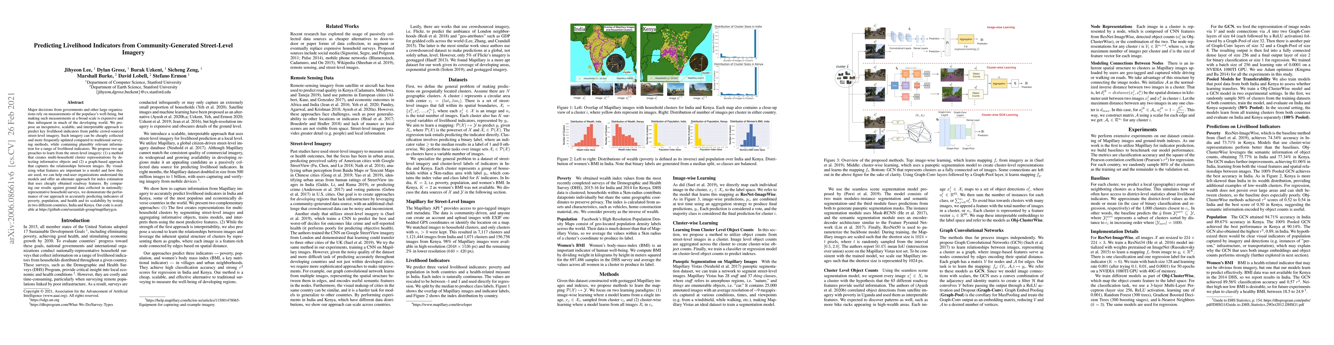
Major decisions from governments and other large organizations rely on measurements of the populace's well-being, but making such measurements at a broad scale is expensive and thus infrequent in much of the developing world. We propose an inexpensive, scalable, and interpretable approach to predict key livelihood indicators from public crowd-sourced street-level imagery. Such imagery can be cheaply collected and more frequently updated compared to traditional surveying methods, while containing plausibly relevant information for a range of livelihood indicators. We propose two approaches to learn from the street-level imagery: (1) a method that creates multi-household cluster representations by detecting informative objects and (2) a graph-based approach that captures the relationships between images. By visualizing what features are important to a model and how they are used, we can help end-user organizations understand the models and offer an alternate approach for index estimation that uses cheaply obtained roadway features. By comparing our results against ground data collected in nationally-representative household surveys, we demonstrate the performance of our approach in accurately predicting indicators of poverty, population, and health and its scalability by testing in two different countries, India and Kenya. Our code is available at https://github.com/sustainlab-group/mapillarygcn.

AI Key Findings

Generated Sep 03, 2025

Methodology

The paper proposes an approach to predict key livelihood indicators (poverty, population, and health) from community-generated street-level imagery using two methods: image-wise learning and cluster-wise learning. Image-wise learning maps individual images to the label space, while cluster-wise learning utilizes object counts from street-level images in a cluster and trains a classifier or regression model on these counts.

Key Results

  • GCN models achieved high accuracy in predicting wealth, population, and women's BMI in both India and Kenya.
  • Obj-ClusterWise models, relying solely on object counts, performed comparably to GCN models, suggesting they capture useful semantic information.
  • Pooled models (trained on combined data from both countries) achieved the best or close-to-best performance for most tasks, indicating that combining spatial information, object counts, and visual features can generalize well across countries.
  • The study demonstrated strong performance in predicting indicators like women's BMI, which had not been the focus of machine learning methods previously.
  • The method was shown to be scalable, making predictions across India and Kenya.

Significance

This research presents a scalable, interpretable pipeline for predicting livelihood indicators using only crowdsourced street-level imagery, offering a cheaper yet effective alternative to traditional surveying methods for measuring the well-being of developing regions.

Technical Contribution

The paper introduces Graph Convolutional Networks (GCN) designed to learn relationships between images through feature-rich nodes and spatial distance-based edges, achieving the best performance on most tasks.

Novelty

The research offers a novel approach by leveraging cluster-wise representations and a graph-based method to capture the spatial structure of clusters, making it different from existing methods that do not effectively utilize spatial relationships between images.

Limitations

  • The study acknowledges the inconsistent quality of large-scale, crowd-sourced datasets.
  • Performance on women's BMI prediction was limited by the lack of data from Kenya in the 2014 DHS.

Future Work

  • Future experiments plan to classify a healthy BMI range (18.5 to 24.9) instead of just predicting high or low BMI.
  • Exploration of additional interpretable features from street-level imagery to enhance model transparency and trust among policymakers and practitioners.

Paper Details

PDF Preview

Download PDF

Key Terms

indicators (0.279)
indicators (0.265)
street (0.259)
organizations (0.240)
collected (0.183)
collected (0.181)
countries (0.142)
approach (0.142)

Citation Network

Current paper (gray), citations (green), references (blue)

Display is limited for performance on very large graphs.

Current Paper
Citations
References
Click to view
Title Authors Year Actions

Comments (0)

This website uses cookies to ensure you get the best experience. Learn more