Summary
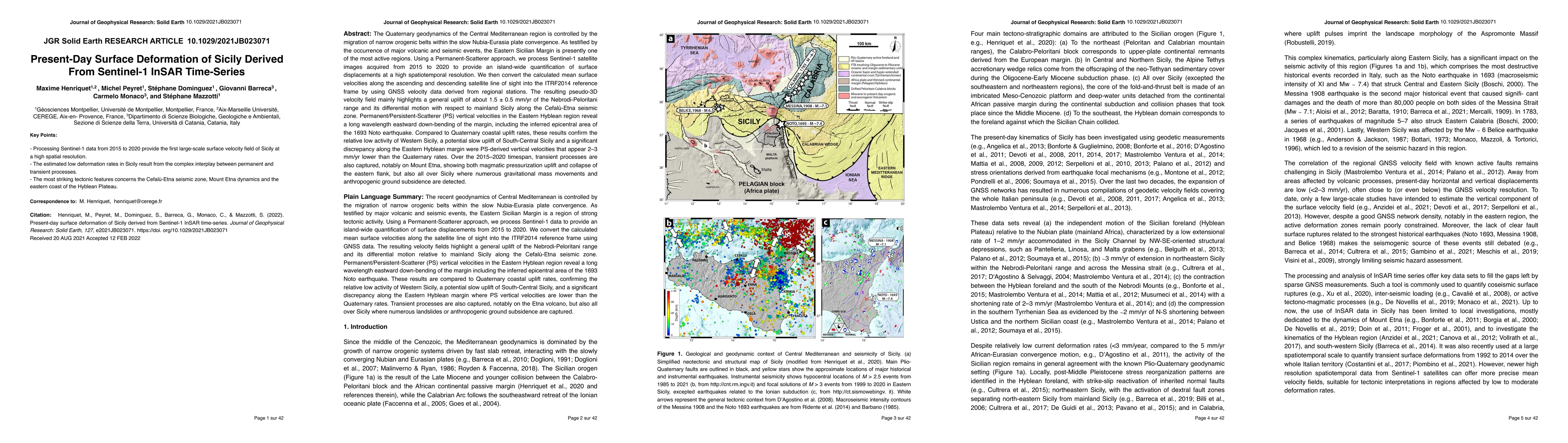
The Quaternary geodynamics of the Central Mediterranean region is controlled by the migration of narrow orogenic belts within the slow Nubia-Eurasia plate convergence. As testified by the occurrence of major volcanic and seismic events, the Eastern Sicilian Margin is presently one of the most active regions. Using a Permanent-Scatterer approach, we process Sentinel-1 satellite images acquired from 2015 to 2020 to provide an island-wide quantification of surface displacements at a high spatiotemporal resolution. We then convert the calculated mean surface velocities along the ascending and descending satellite line of sight into the ITRF2014 reference frame by using GNSS velocity data derived from regional stations. The resulting pseudo-3D velocity field mainly highlights a general uplift of about $1.5 \pm 0.5$ mm/yr of the Nebrodi-Peloritani range and its differential motion with respect to mainland Sicily along the Cefal\`u-Etna seismic zone. Permanent/Persistent-Scatterer (PS) vertical velocities in the Eastern Hyblean region reveal a long wavelength eastward down-bending of the margin, including the inferred epicentral area of the 1693 Noto earthquake. Compared to Quaternary coastal uplift rates, these results confirm the relative low activity of Western Sicily, a potential slow uplift of South-Central Sicily and a significant discrepancy along the Eastern Hyblean margin were PS-derived vertical velocities that appear 2-3 mm/yr lower than the Quaternary rates. Over the 2015--2020 timespan, transient processes are also captured, notably on Mount Etna, showing both magmatic pressurization uplift and collapse of the eastern flank, but also all over Sicily where numerous gravitational mass movements and anthropogenic ground subsidence are detected.
AI Key Findings
Get AI-generated insights about this paper's methodology, results, and significance.
Paper Details
PDF Preview
Key Terms
Citation Network
Current paper (gray), citations (green), references (blue)
Display is limited for performance on very large graphs.
Similar Papers
Found 4 papersAutonomous Extraction of Millimeter-scale Deformation in InSAR Time Series Using Deep Learning
Paul A. Johnson, Romain Jolivet, Claudia Hulbert et al.
Surface Deformation of New York City from Multitemporal Interferometric Analysis of Sentinel-1 SAR Datasets
Manoochehr Shirzaei
| Title | Authors | Year | Actions |
|---|
Comments (0)