Publication
Metrics
AI Quick Summary
The paper introduces GraphMapper, a unified framework for extracting vector maps from satellite images using a novel "primitive graph" representation. The framework outperforms existing methods in building footprint regularization and road network topology reconstruction.
Paper Preview
Abstract
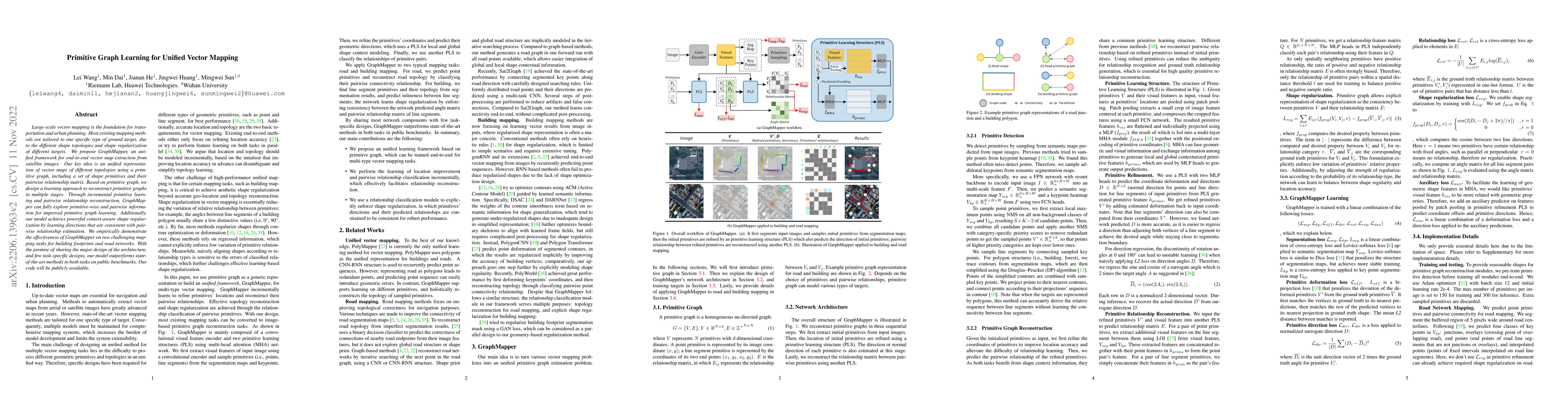
Large-scale vector mapping is important for transportation, city planning, and survey and census. We propose GraphMapper, a unified framework for end-to-end vector map extraction from satellite images. Our key idea is a novel unified representation of shapes of different topologies named "primitive graph", which is a set of shape primitives and their pairwise relationship matrix. Then, we convert vector shape prediction, regularization, and topology reconstruction into a unique primitive graph learning problem. Specifically, GraphMapper is a generic primitive graph learning network based on global shape context modelling through multi-head-attention. An embedding space sorting method is developed for accurate primitive relationship modelling. We empirically demonstrate the effectiveness of GraphMapper on two challenging mapping tasks, building footprint regularization and road network topology reconstruction. Our model outperforms state-of-the-art methods in both tasks on public benchmarks. All code will be publicly available.
AI Key Findings
Get AI-generated insights about this paper's methodology, results, significance, and more — seven facets brought into focus.
Impact
Paper Details
Authors
PDF Preview
Key Terms
Citation Network
Current paper (gray), citations (green), references (blue)
Display is limited for performance on very large graphs.
Discussion 0