ProDiG integrates a diffusion model fine‑tuned on aerial imagery with a progressive altitude Gaussian splatting pipeline; it synthesizes intermediate‑altitude views, refines them using geometry‑aware causal attention with epipolar masking, and adapts Gaussian scale and opacity via a distance‑adaptive module.
ProDiG: Progressive Diffusion-Guided Gaussian Splatting for Aerial to Ground Reconstruction
Publication
Metrics
Quick Answers
What methodology did the authors use?
ProDiG integrates a diffusion model fine‑tuned on aerial imagery with a progressive altitude Gaussian splatting pipeline; it synthesizes intermediate‑altitude views, refines them using geometry‑aware causal attention with epipolar masking, and adapts Gaussian scale and opacity via a distance‑adaptive module. More in Methodology →
What are the key results?
ProDiG consistently outperforms state‑of‑the‑art baselines on both synthetic and real‑world datasets, achieving higher DreamSim, PSNR, SSIM, and lower LPIPS scores. — The progressive altitude strategy with intermediate view synthesis and causal attention yields geometrically consistent ground‑level renderings and reduces hallucinations. More in Key Results →
Why is this work significant?
This work enables high‑quality ground‑level reconstruction from aerial‑only data without requiring ground‑truth views, addressing a major bottleneck in large‑scale 3D site modeling and opening possibilities for autonomous mapping and urban planning. More in Significance →
What are the main limitations?
Dependence on accurate camera poses and calibrated intrinsics, which may be challenging in uncontrolled aerial imagery. — Performance may degrade under extreme lighting or weather variations not covered in the training data. More in Limitations →
Abstract
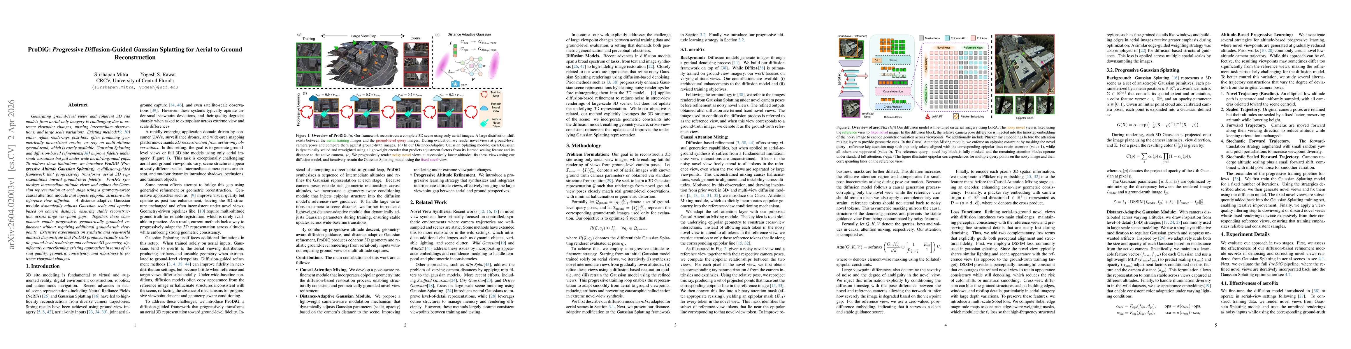
Generating ground-level views and coherent 3D site models from aerial-only imagery is challenging due to extreme viewpoint changes, missing intermediate observations, and large scale variations. Existing methods either refine renderings post-hoc, often producing geometrically inconsistent results, or rely on multi-altitude ground-truth, which is rarely available. Gaussian Splatting and diffusion-based refinements improve fidelity under small variations but fail under wide aerial-to-ground gaps. To address these limitations, we introduce ProDiG (Progressive Altitude Gaussian Splatting), a diffusion-guided framework that progressively transforms aerial 3D representations toward ground-level fidelity. ProDiG synthesizes intermediate-altitude views and refines the Gaussian representation at each stage using a geometry-aware causal attention module that injects epipolar structure into reference-view diffusion. A distance-adaptive Gaussian module dynamically adjusts Gaussian scale and opacity based on camera distance, ensuring stable reconstruction across large viewpoint gaps. Together, these components enable progressive, geometrically grounded refinement without requiring additional ground-truth viewpoints. Extensive experiments on synthetic and real-world datasets demonstrate that ProDiG produces visually realistic ground-level renderings and coherent 3D geometry, significantly outperforming existing approaches in terms of visual quality, geometric consistency, and robustness to extreme viewpoint changes.
Key Findings, in focus
Seven facets of this paper, analysed and brought into focus by AI.
This work enables high‑quality ground‑level reconstruction from aerial‑only data without requiring ground‑truth views, addressing a major bottleneck in large‑scale 3D site modeling and opening possibilities for autonomous mapping and urban planning.
- ProDiG consistently outperforms state‑of‑the‑art baselines on both synthetic and real‑world datasets, achieving higher DreamSim, PSNR, SSIM, and lower LPIPS scores.
- The progressive altitude strategy with intermediate view synthesis and causal attention yields geometrically consistent ground‑level renderings and reduces hallucinations.
- The distance‑adaptive Gaussian module stabilizes reconstruction across large viewpoint gaps, improving structural fidelity as shown in ablation studies.
This work enables high‑quality ground‑level reconstruction from aerial‑only data without requiring ground‑truth views, addressing a major bottleneck in large‑scale 3D site modeling and opening possibilities for autonomous mapping and urban planning.
A unified framework that progressively refines Gaussian splatting representations via diffusion‑guided intermediate view synthesis, geometry‑aware causal attention with epipolar constraints, and a distance‑adaptive Gaussian scaling mechanism, all trained with perceptual and multi‑scale Sobel losses.
First to combine progressive altitude diffusion refinement with epipolar‑aware causal attention and distance‑adaptive Gaussian scaling for aerial‑to‑ground reconstruction, eliminating the need for ground‑truth views and achieving robust performance across extreme viewpoint changes.
- Dependence on accurate camera poses and calibrated intrinsics, which may be challenging in uncontrolled aerial imagery.
- Performance may degrade under extreme lighting or weather variations not covered in the training data.
- Extend ProDiG to dynamic scenes and real‑time deployment by integrating efficient diffusion backbones.
- Incorporate semantic or depth priors to further enhance structural consistency and handle occlusions.
Discussion 0