Quick Summary:

This paper proposes a method to estimate internal displacement in Ukraine using anonymized GPS mobile phone data, providing real-time, population-level insights during the early stages of the Russian invasion in 2022. The approach offers reliable, detailed spatio-temporal monitoring of displacement, crucial for timely humanitarian responses.

Summary

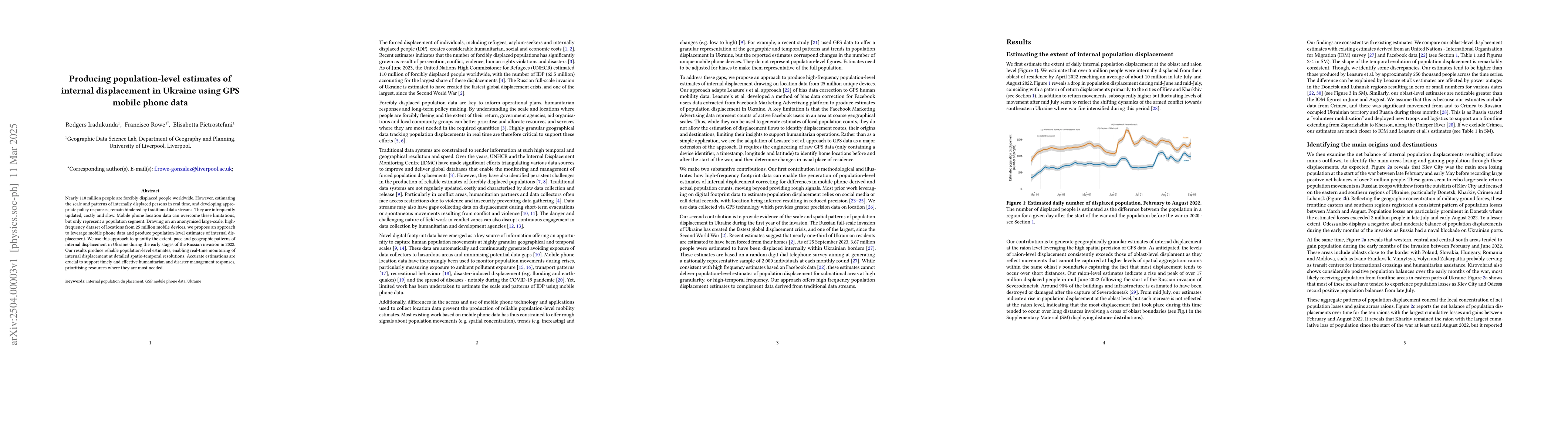
Nearly 110 million people are forcibly displaced people worldwide. However, estimating the scale and patterns of internally displaced persons in real time, and developing appropriate policy responses, remain hindered by traditional data streams. They are infrequently updated, costly and slow. Mobile phone location data can overcome these limitations, but only represent a population segment. Drawing on an anonymised large-scale, high-frequency dataset of locations from 25 million mobile devices, we propose an approach to leverage mobile phone data and produce population-level estimates of internal displacement. We use this approach to quantify the extent, pace and geographic patterns of internal displacement in Ukraine during the early stages of the Russian invasion in 2022. Our results produce reliable population-level estimates, enabling real-time monitoring of internal displacement at detailed spatio-temporal resolutions. Accurate estimations are crucial to support timely and effective humanitarian and disaster management responses, prioritising resources where they are most needed.

AI Key Findings

Generated Jun 10, 2025

Methodology

The research utilized anonymized GPS location data from 25 million mobile devices to estimate internal displacement in Ukraine during the early stages of the Russian invasion in 2022. The approach involved correcting mobile phone-derived population estimates to account for differences in mobile phone technology usage across locations in Ukraine and over time.

Key Results

  • Reliable population-level estimates of internal displacement were produced, enabling real-time monitoring at detailed spatio-temporal resolutions.
  • The study identified urban centers, especially Kiev and Kharkiv, as predominant locations of population displacement during the early months of the invasion.
  • Considerable fluctuations in displacement and return movements were observed, indicating temporary displacements and short-distance returns.
  • The research complemented existing efforts to generate rapid response estimates, providing consistent national-level estimates with those from IOM telephone surveys and social media data.
  • The methodology showed the capacity to provide real-time monitoring of population displacement at high temporal and spatial resolutions.

Significance

This research is crucial for timely and effective humanitarian and disaster management responses, as accurate estimations are essential for prioritizing resources where they are most needed during conflicts and natural disasters.

Technical Contribution

The paper introduced an approach to produce highly granular temporal and spatial population-level estimates of internal displacement using a large dataset of GPS locations from mobile phone devices, overcoming limitations of traditional data streams.

Novelty

This work differs from existing research by leveraging pre-conflict population data to adjust location data from mobile phone users, moving beyond providing rough signals of population movements to offering estimates of the extent of population movements.

Limitations

  • The study could not characterize the population being displaced or their underlying reasons, as mobile phone data only offer location-time information without socio-demographic details.
  • The research was unable to distinguish between permanent and semi-permanent returns, as individual mobile device records provided irregular longitudinal sequences of locations.
  • No comparable estimates existed to evaluate the accuracy of population-level estimates derived from digital traces like smartphone data.

Future Work

  • Future efforts could focus on making available a repository of high-quality datasets, such as comprehensive population registry or administrative sources, to assess the accuracy of population-level estimates derived from digital trace data.
  • Assessing the integration of area-level data of the resident population with highly granular displacement estimates derived from GPS location data could help more accurately capture the socio-demographic profile of displaced communities.

Paper Details

PDF Preview

Download PDF

Key Terms

No key terms available for this paper.

Title Authors Year Actions
Long-term disparities in the recovery of urban mobility after COVID-19 in Latin America
Carmen Cabrera, Francisco Rowe, Miguel Gonz'alez-Leonardo, Andrea Nasuto, Ruth Neville
2025
View Paper

Comments (0)

This website uses cookies to ensure you get the best experience. Learn more