ArxivLens

Quick Summary:

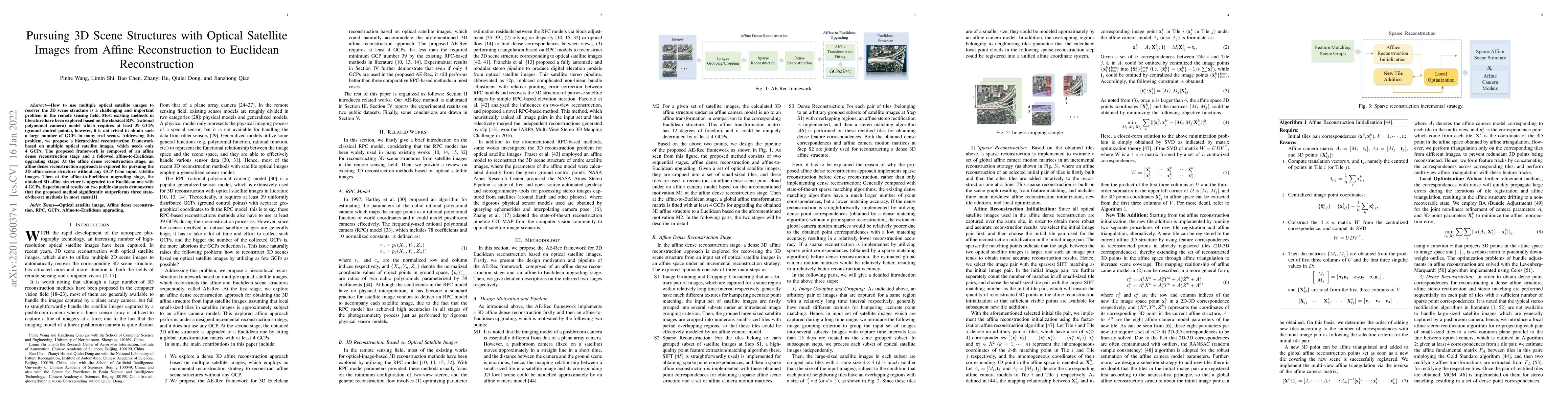
This paper proposes a hierarchical framework for reconstructing 3D scene structures from multiple optical satellite images, requiring only 4 GCPs instead of 39. The method involves affine dense reconstruction followed by affine-to-Euclidean upgrading, outperforming existing state-of-the-art methods in experiments.

DOI: 10.1109/TGRS.2022.3213546
arXiv Id: 2201.06037
Comments: 11 pages, 5 figures
Date Published: 2022-12-07
Date Updated: 2022-12-07

Categories:

Key Terms (TF-IDF):

affine (0.331)
affine (0.320)
stage (0.246)
stage (0.242)
satellite (0.235)
reconstruction (0.235)
satellite (0.234)
reconstruction (0.231)
euclidean (0.231)
euclidean (0.212)
dense (0.206)
scene (0.202)
dense (0.199)
scene (0.196)
explored (0.179)
images (0.175)
images (0.170)
explored (0.168)
remote sensing (0.133)
remote (0.132)
License: http://creativecommons.org/licenses/by/4.0/

Summary:

How to use multiple optical satellite images to recover the 3D scene structure is a challenging and important problem in the remote sensing field. Most existing methods in literature have been explored based on the classical RPC (rational polynomial camera) model which requires at least 39 GCPs (ground control points), however, it is not trivial to obtain such a large number of GCPs in many real scenes. Addressing this problem, we propose a hierarchical reconstruction framework based on multiple optical satellite images, which needs only 4 GCPs. The proposed framework is composed of an affine dense reconstruction stage and a followed affine-to-Euclidean upgrading stage: At the affine dense reconstruction stage, an affine dense reconstruction approach is explored for pursuing the 3D affine scene structure without any GCP from input satellite images. Then at the affine-to-Euclidean upgrading stage, the obtained 3D affine structure is upgraded to a Euclidean one with 4 GCPs. Experimental results on two public datasets demonstrate that the proposed method significantly outperforms three state-of-the-art methods in most cases.

Citation & Reference Network Visualization

This graph shows how this paper is connected to other research. The current paper is shown in dark gray, papers that cite it are in green, and papers it references are in blue. You can:

Current Paper
Papers citing this work (Citations)
Papers cited by this work (References)

• Hover over any node to see the paper title

• Click a node to view that paper's details

• Drag nodes to rearrange the graph

• Use the zoom controls (bottom right) to zoom in/out

Citations and References

Title Authors Year Actions
Refined equivalent pinhole model for large-scale 3D reconstruction from spaceborne CCD imagery
Danyang Hong, Anzhu Yu, Song Ji, Xuanbei Lu, Wenyue Guo, Xuefeng Cao, Chunping Qiu
2024
View Paper
Digital Surface Model Generation from Satellite Images Based on Double-Penalty Bundle Adjustment Optimization
Henan Li, Junping Yin, Liguo Jiao
2024
View Paper
An Improved 3D Reconstruction Method for Satellite Images Based on Generative Adversarial Network Image Enhancement
Henan Li, Junping Yin, Liguo Jiao
2024
View Paper
Cayley Rotation Averaging: Multiple Camera Averaging Under the Cayley Framework
Qiulei Dong, Shuang Deng, Yuzhen Liu
2024
View Paper
SparseDet: A Simple and Effective Framework for Fully Sparse LiDAR-Based 3-D Object Detection
Lin Liu, Ziying Song, Qiming Xia, Feiyang Jia, Caiyan Jia, Lei Yang, Yan Gong, Hongyu Pan
2024
View Paper
VoxelNextFusion: A Simple, Unified, and Effective Voxel Fusion Framework for Multimodal 3-D Object Detection
Ziying Song, Guoxin Zhang, Jun Xie, Lin Liu, Caiyan Jia, Shaoqing Xu, Zhepeng Wang
2024
View Paper
RS-MVSNet: Inferring the Earth's Digital Surface Model from Multi-View Optical Remote Sensing Images
Nannan Liu, Pinhe Wang, Siyi Xiang, Nannan Gu, Feng Wang
2023
View Paper
SMOC-Net: Leveraging Camera Pose for Self-Supervised Monocular Object Pose Estimation
Tao Tan, Qiulei Dong
2023
View Paper
Multi-Sem Fusion: Multimodal Semantic Fusion for 3-D Object Detection
Shaoqing Xu, Dingfu Zhou, Jin Fang, Peng Wang, Liangjun Zhang
2022
View Paper
3D Reconstruction System Based on Multi Sensor
Fan Yu, Xue Fan
2022
View Paper
Target Tracking System Based on Dynamic Scene
Fan Yu, Xue Fan
2022
View Paper
Optimization Method for DSM Reconstruction of Equivalent Pinhole Model Based on Iterative Resampling and Chunking Process
Yongjian Li, Song Ji, Danchao Gong, D. Fan, Jiaxuan Song, Ding Gao
2025
View Paper
FVMD-ISRe: 3-D Reconstruction From Few-View Multidate Satellite Images Based on the Implicit Surface Representation of Neural Radiance Fields
Chi Zhang, Yiming Yan, Chunhui Zhao, Nan Su, Weikun Zhou
2024
View Paper
Multiscale Spatial-Frequency Domain Dynamic Pansharpening of Remote Sensing Images Integrated With Wavelet Transform
Yingjie Li, Weiqi Jin, Su Qiu, Yuqing He
2024
View Paper
3-D HANet: A Flexible 3-D Heatmap Auxiliary Network for Object Detection
Qiming Xia, Yidong Chen, Guorong Cai, Guikun Chen, Daoshun Xie, Jinhe Su, Zongyue Wang
2023
View Paper

Similar Papers

Graph-Guided Scene Reconstruction from Images with 3D Gaussian Splatting

Hao Wang, Yiyang Yao, Gaochao Song, Chong Cheng, Gangjian Zhang, Qinzheng Zhou

Published: 2025-02-24

Multi-view 3D surface reconstruction from SAR images by inverse rendering

Loïc Denis, Florence Tupin, Emile Barbier--Renard, Nicolas Trouvé

Published: 2025-02-14

Comments (0)

This website uses cookies to ensure you get the best experience. Learn more