Qualitative Relational Mapping and Navigation for Planetary Rovers
Publication
Metrics
Paper Preview
Abstract
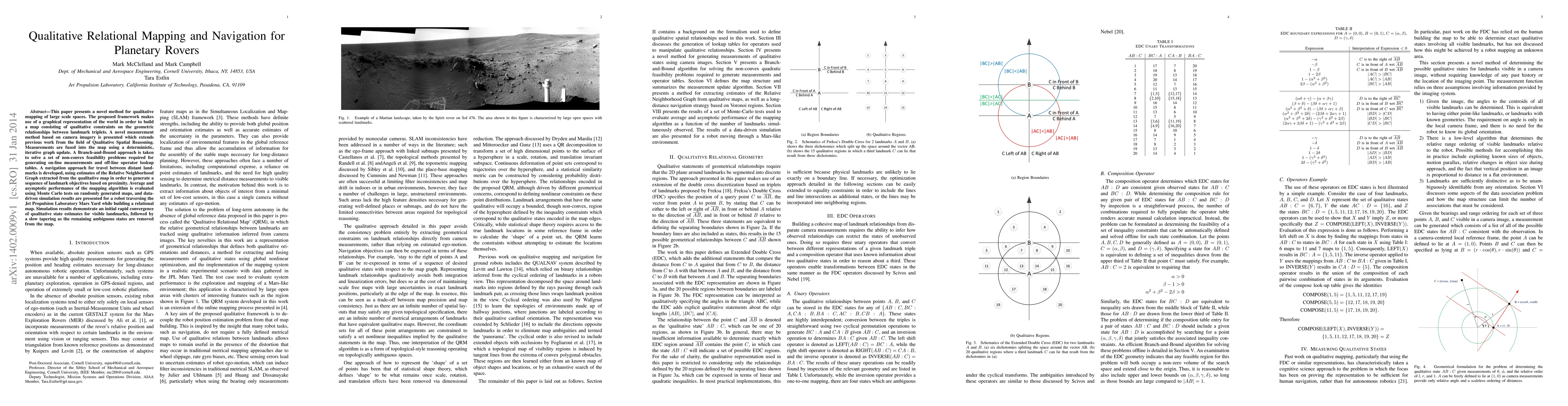
This paper presents a novel method for qualitative mapping of large scale spaces. The proposed framework makes use of a graphical representation of the world in order to build a map consisting of qualitative constraints on the geometric relationships between landmark triplets. A novel measurement method based on camera imagery is presented which extends previous work from the field of Qualitative Spatial Reasoning. Measurements are fused into the map using a deterministic, iterative graph update. A Branch-and-Bound approach is taken to solve a set of non-convex feasibility problems required for generating on-line measurements and off-line operator lookup tables. A navigation approach for travel between distant landmarks is developed, using estimates of the Relative Neighborhood Graph extracted from the qualitative map in order to generate a sequence of landmark objectives based on proximity. Average and asymptotic performance of the mapping algorithm is evaluated using Monte Carlo tests on randomly generated maps, and data-driven simulation results are presented for a robot traversing the Jet Propulsion Laboratory Mars Yard while building a relational map. Simulation results demonstrate an initial rapid convergence of qualitative state estimates for visible landmarks, followed by a slow tapering as the remaining ambiguous states are removed from the map.
AI Key Findings
Get AI-generated insights about this paper's methodology, results, significance, and more — seven facets brought into focus.
Impact
Paper Details
PDF Preview
Key Terms
Citation Network
Current paper (gray), citations (green), references (blue)
Display is limited for performance on very large graphs.
Discussion 0