Radiometric Interferometry for Deep Space Navigation using Geostationary Satellites

PDF

Publication

Published: Jul 26, 2025
Updated: Aug 04, 2025
Categories: astro-ph.IM, physics.space-ph

Metrics

Source: ArXiv

Quick Actions

View PDF

Quick Answers

What methodology did the authors use?

This research proposes a space-based VLBI approach using Geostationary Earth Orbit (GEO) satellites for deep space navigation, aiming to extend baselines, eliminate atmospheric distortions, and ensure continuous visibility. More in Methodology →

What are the key results?

The GEO-based VLBI system achieves a total angular error of approximately 3.73 nanoradians. — The space-based architecture nearly doubles the geometrical availability for interferometric tracking. More in Key Results →

Why is this work significant?

This research supports the feasibility of a GEO-based VLBI concept for deep space navigation, addressing limitations of traditional terrestrial VLBI systems and offering continuous tracking capabilities crucial for future space missions. More in Significance →

What are the main limitations?

The system's performance is affected by signal-to-noise ratio (SNR) limitations, Doppler-induced phase shifts, clock synchronization uncertainty, and orbit determination errors of GEO satellites. — The proposed system relies on dedicated post-processed orbit determination (OD) accuracy, which may introduce additional errors if not precisely maintained. More in Limitations →

Paper Preview

Abstract

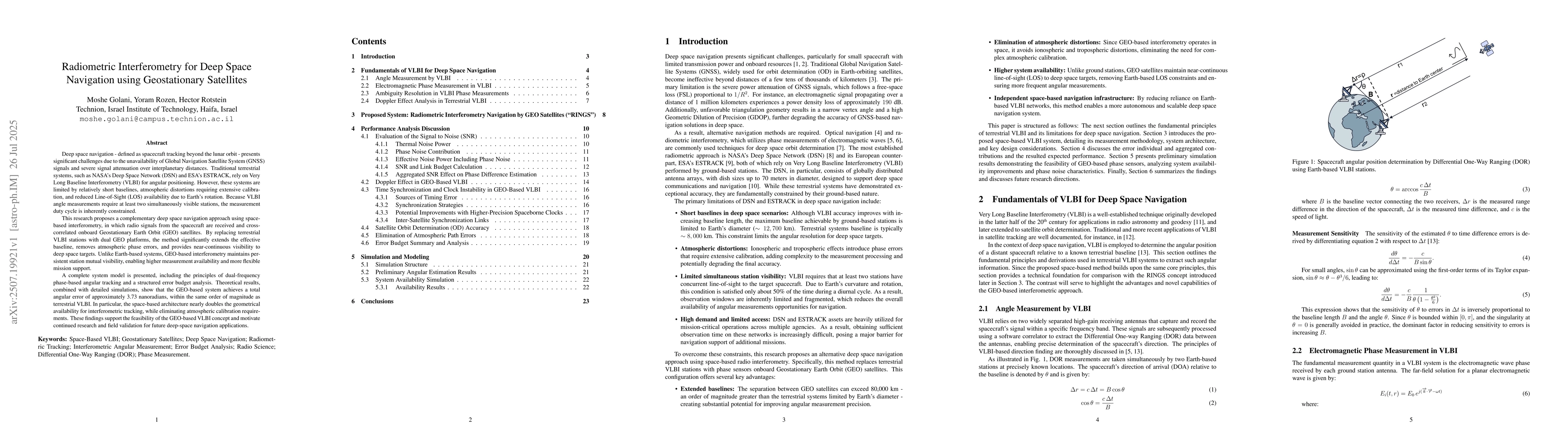
Deep space navigation presents significant challenges due to the unavailability of Global Navigation Satellite System (GNSS) signals and severe signal attenuation over interplanetary distances. Traditional terrestrial systems, such as NASA Deep Space Network (DSN) and ESA ESTRACK, rely on Very Long Baseline Interferometry (VLBI) for angular positioning. However, these systems are limited by relatively short baselines, atmospheric distortions requiring extensive calibration, and reduced visibility availability due to Earth rotation. This research proposes a complementary deep space navigation approach using space based interferometry, in which radio signals from the spacecraft are received and cross correlated onboard Geostationary Earth Orbit (GEO) satellites. By replacing terrestrial VLBI stations with dual GEO platforms, the method significantly extends the effective baseline, removes atmospheric phase errors, and provides almost continuous visibility to deep space targets. Unlike Earth based systems, GEO based interferometry maintains persistent station mutual visibility, enabling higher measurement availability and more flexible mission support. A complete system model is presented, including the principles of dual frequency phase based angular tracking and a structured error budget analysis. Theoretical results show that the GEO based system achieves a total angular error of approximately 3.73 nanoradians, within the same order of magnitude as terrestrial VLBI. Space based architecture nearly doubles the geometrical availability for interferometric tracking, while eliminating atmospheric distortions. These findings support the feasibility of the GEO based VLBI concept and motivate continued research and field validation for future deep space navigation applications.

AI Key Findings

Generated Sep 03, 2025

Methodology — What approach did the authors take?

This research proposes a space-based VLBI approach using Geostationary Earth Orbit (GEO) satellites for deep space navigation, aiming to extend baselines, eliminate atmospheric distortions, and ensure continuous visibility.

Key Results — What are the main findings?

  • The GEO-based VLBI system achieves a total angular error of approximately 3.73 nanoradians.
  • The space-based architecture nearly doubles the geometrical availability for interferometric tracking.
  • Atmospheric distortions are eliminated, reducing the need for extensive calibration.
  • The system offers persistent station mutual visibility, enabling higher measurement availability and flexible mission support.

Significance — Why does this research matter?

This research supports the feasibility of a GEO-based VLBI concept for deep space navigation, addressing limitations of traditional terrestrial VLBI systems and offering continuous tracking capabilities crucial for future space missions.

Technical Contribution — What is the technical contribution?

The paper presents a complete system model for a space-based VLBI concept, including dual frequency phase-based angular tracking and a structured error budget analysis.

Novelty — What is new about this work?

The proposed GEO-based VLBI concept extends the capabilities of traditional ground-based VLBI systems by leveraging the advantages of space-based architecture, such as continuous target visibility, immunity to atmospheric effects, and extended baselines.

Limitations — What are the limitations of this study?

  • The system's performance is affected by signal-to-noise ratio (SNR) limitations, Doppler-induced phase shifts, clock synchronization uncertainty, and orbit determination errors of GEO satellites.
  • The proposed system relies on dedicated post-processed orbit determination (OD) accuracy, which may introduce additional errors if not precisely maintained.

Future Work — What did the authors propose for future work?

  • Further research should focus on improving onboard clock precision, such as using space-qualified Cesium standards.
  • Development of inter-satellite synchronization links could enhance time synchronization accuracy.

Paper Details

Paper ID: 2507.19921
Categories:
astro-ph.IM physics.space-ph

How to Cite This Paper

BibTeX
@article{rotstein2025radiometric,
  title         = {Radiometric Interferometry for Deep Space Navigation using Geostationary
  Satellites},
  author        = {Rotstein, Hector and Golani, Moshe and Rozen, Yoram},
  year          = {2025},
  eprint        = {2507.19921},
  archivePrefix = {arXiv},
  primaryClass  = {astro-ph.IM},
}
APA 7
Rotstein, H., Golani, M., & Rozen, Y. (2025). Radiometric Interferometry for Deep Space Navigation using Geostationary
  Satellites. arXiv. https://arxiv.org/abs/2507.19921
MLA 9
Rotstein, Hector, et al. "Radiometric Interferometry for Deep Space Navigation using Geostationary
  Satellites." arXiv, 2025, arxiv.org/abs/2507.19921.

Citation Network

Current paper (gray), citations (green), references (blue)

Display is limited for performance on very large graphs.

Current Paper
Citations
References
Click to view

No citations found for this paper.

Comments (0)

This website uses cookies to ensure you get the best experience. Learn more