Publication

Published: Feb 28, 2026
Categories: cs.CV

Metrics

Source: ArXiv

Quick Actions

View PDF

Quick Answers

What methodology did the authors use?

RC-GeoCP introduces a radar-anchored geometric consensus framework that aligns camera semantics with 4D radar geometry, selects informative BEV tokens via uncertainty-aware communication, and aggregates multi-agent information using a consensus-driven assembler. More in Methodology →

What are the key results?

Achieves state-of-the-art [email protected]/[email protected] on V2X-Radar and V2X-R datasets, outperforming prior methods by up to 7.8% and 6.4% respectively. — Reduces communication cost to 2.39 units, a >40% bandwidth savings compared to baseline methods. More in Key Results →

Why is this work significant?

The work enables accurate, geometry-consistent radar-camera collaborative perception with minimal bandwidth, facilitating scalable V2X systems in adverse weather and limited sensor scenarios. More in Significance →

What are the main limitations?

Evaluation limited to homogeneous radar-camera setups; performance on heterogeneous V2X ecosystems remains untested. — Experiments conducted on two datasets; real-world large-scale deployment and latency profiling are pending. More in Limitations →

Paper Preview

Abstract

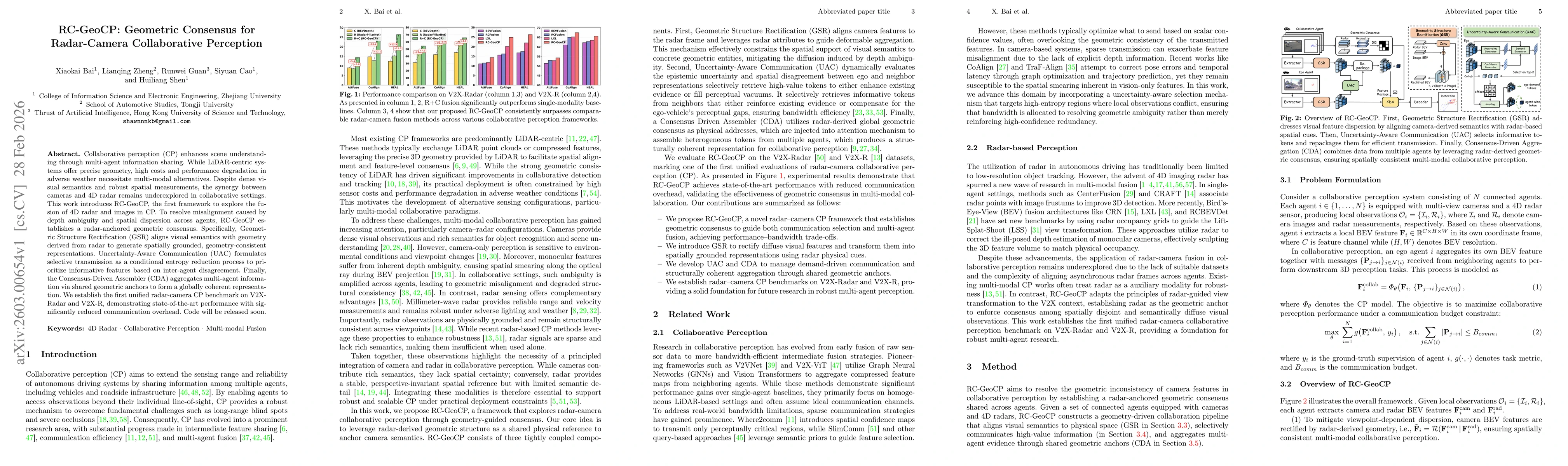
Collaborative perception (CP) enhances scene understanding through multi-agent information sharing. While LiDAR-centric systems offer precise geometry, high costs and performance degradation in adverse weather necessitate multi-modal alternatives. Despite dense visual semantics and robust spatial measurements, the synergy between cameras and 4D radar remains underexplored in collaborative settings. This work introduces RC-GeoCP, the first framework to explore the fusion of 4D radar and images in CP. To resolve misalignment caused by depth ambiguity and spatial dispersion across agents, RC-GeoCP establishes a radar-anchored geometric consensus. Specifically, Geometric Structure Rectification (GSR) aligns visual semantics with geometry derived from radar to generate spatially grounded, geometry-consistent representations. Uncertainty-Aware Communication (UAC) formulates selective transmission as a conditional entropy reduction process to prioritize informative features based on inter-agent disagreement. Finally, the Consensus-Driven Assembler (CDA) aggregates multi-agent information via shared geometric anchors to form a globally coherent representation. We establish the first unified radar-camera CP benchmark on V2X-Radar and V2X-R, demonstrating state-of-the-art performance with significantly reduced communication overhead. Code will be released soon.

AI Key Findings

Generated Mar 04, 2026

Methodology — What approach did the authors take?

RC-GeoCP introduces a radar-anchored geometric consensus framework that aligns camera semantics with 4D radar geometry, selects informative BEV tokens via uncertainty-aware communication, and aggregates multi-agent information using a consensus-driven assembler.

Key Results — What are the main findings?

  • Achieves state-of-the-art [email protected]/[email protected] on V2X-Radar and V2X-R datasets, outperforming prior methods by up to 7.8% and 6.4% respectively.
  • Reduces communication cost to 2.39 units, a >40% bandwidth savings compared to baseline methods.
  • Demonstrates robust performance under pose noise and 100 ms temporal misalignment, maintaining higher AP than competitors.

Significance — Why does this research matter?

The work enables accurate, geometry-consistent radar-camera collaborative perception with minimal bandwidth, facilitating scalable V2X systems in adverse weather and limited sensor scenarios.

Technical Contribution — What is the technical contribution?

A unified pipeline combining Geometric Structure Rectification, Uncertainty-Aware Communication, and Consensus-Driven Assembly to fuse radar and camera data efficiently.

Novelty — What is new about this work?

First radar-camera collaborative perception framework that uses radar-derived geometric consensus to resolve depth ambiguity, employs sparse token communication, and introduces multi-scale agent-wise tokens for global context preservation.

Limitations — What are the limitations of this study?

  • Evaluation limited to homogeneous radar-camera setups; performance on heterogeneous V2X ecosystems remains untested.
  • Experiments conducted on two datasets; real-world large-scale deployment and latency profiling are pending.

Future Work — What did the authors propose for future work?

  • Extend the framework to heterogeneous V2X environments incorporating LiDAR, IMU, and other modalities.
  • Investigate real-time deployment and adaptive token selection under varying network conditions.

Paper Details

Paper ID: 2603.00654
Comments: 18 pages, 5 figures, 7 tables
Categories:
cs.CV

How to Cite This Paper

BibTeX
@article{shen2026rc,
  title         = {RC-GeoCP: Geometric Consensus for Radar-Camera Collaborative Perception},
  author        = {Shen, Huiliang and Zheng, Lianqing and Guan, Runwei and others},
  year          = {2026},
  eprint        = {2603.00654},
  archivePrefix = {arXiv},
  primaryClass  = {cs.CV},
}
APA 7
Shen, H., Zheng, L., Guan, R., Cao, S., & Bai, X. (2026). RC-GeoCP: Geometric Consensus for Radar-Camera Collaborative Perception. arXiv. https://arxiv.org/abs/2603.00654
MLA 9
Shen, Huiliang, et al. "RC-GeoCP: Geometric Consensus for Radar-Camera Collaborative Perception." arXiv, 2026, arxiv.org/abs/2603.00654.

Similar Papers

Found 4 papers

RC-AutoCalib: An End-to-End Radar-Camera Automatic Calibration Network

Van-Tin Luu, Yon-Lin Cai, Vu-Hoang Tran et al.

2025-05-28

RC-BEVFusion: A Plug-In Module for Radar-Camera Bird's Eye View Feature Fusion

Lukas Stäcker, Shashank Mishra, Philipp Heidenreich et al.

2023-09-29

CRN: Camera Radar Net for Accurate, Robust, Efficient 3D Perception

Youngseok Kim, Juyeb Shin, Sanmin Kim et al.

2023-12-27

Comments (0)

This website uses cookies to ensure you get the best experience. Learn more