ArxivLens
ArXiv cs.CV cs.RO eess.IV

Real-Time Dense Stereo Embedded in A UAV for Road Inspection

1904.06017 Published Apr 15, 2019
View PDF

Publication

Published: Apr 15, 2019
Categories: cs.CV, cs.RO, eess.IV

Metrics

Source: ArXiv

AI Quick Summary

This paper introduces a real-time dense stereo vision system embedded in a UAV for assessing road surface conditions, utilizing a transformed perspective view to enhance disparity accuracy and reduce computational complexity. The system, implemented on an NVIDIA Jetson TX2 GPU, effectively distinguishes damaged road areas through optimized disparity maps.

Quick Answers

What is "Real-Time Dense Stereo Embedded in A UAV for Road Inspection" about?

This paper introduces a real-time dense stereo vision system embedded in a UAV for assessing road surface conditions, utilizing a transformed perspective view to enhance disparity accuracy and reduce computational complexity. The system, implemented on an NVIDIA Jetson TX2 GPU, effectively distinguishes damaged road areas through optimized disparity maps.

What methodology did the authors use?

The paper presents a robust stereo vision system embedded in a UAV for road inspection, utilizing perspective transformation, disparity computation, optimization, and refinement, followed by disparity transformation for distinguishing damaged road areas. More in Methodology →

What are the key results?

The system improves disparity accuracy and reduces computational complexity through perspective transformation. — A bilateral filter is used to refine cost volumes, enhancing functional minimization in a fully connected Markov random field model. More in Key Results →

Why is this work significant?

This research is significant for ensuring road traffic safety by providing a real-time, robust stereo vision system for road condition assessment using UAVs. More in Significance →

What are the main limitations?

The paper does not discuss limitations explicitly, but potential limitations could include performance in adverse weather conditions or complex road environments. — The evaluation is primarily based on synthetic datasets and may not fully reflect real-world conditions. More in Limitations →

Paper Preview

Abstract

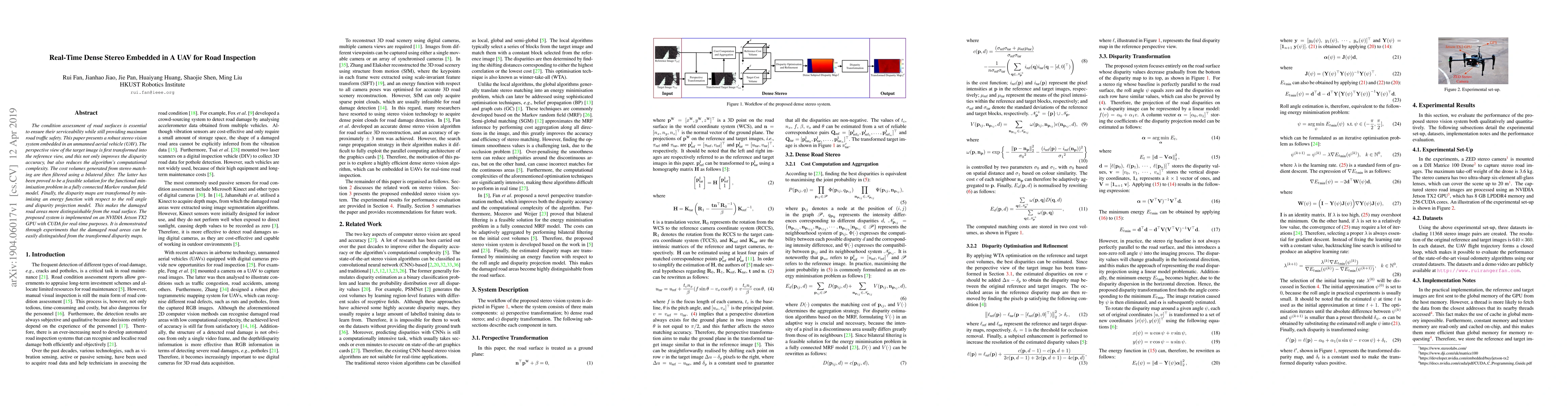
The condition assessment of road surfaces is essential to ensure their serviceability while still providing maximum road traffic safety. This paper presents a robust stereo vision system embedded in an unmanned aerial vehicle (UAV). The perspective view of the target image is first transformed into the reference view, and this not only improves the disparity accuracy, but also reduces the algorithm's computational complexity. The cost volumes generated from stereo matching are then filtered using a bilateral filter. The latter has been proved to be a feasible solution for the functional minimisation problem in a fully connected Markov random field model. Finally, the disparity maps are transformed by minimising an energy function with respect to the roll angle and disparity projection model. This makes the damaged road areas more distinguishable from the road surface. The proposed system is implemented on an NVIDIA Jetson TX2 GPU with CUDA for real-time purposes. It is demonstrated through experiments that the damaged road areas can be easily distinguished from the transformed disparity maps.

Key Findings, in focus

Seven facets of this paper, analysed and brought into focus by AI.

AI-generated · verify against source Generated Sep 07, 2025
In focus · one-line synthesis

This research is significant for ensuring road traffic safety by providing a real-time, robust stereo vision system for road condition assessment using UAVs.

01
MethodologyHow they did it

The paper presents a robust stereo vision system embedded in a UAV for road inspection, utilizing perspective transformation, disparity computation, optimization, and refinement, followed by disparity transformation for distinguishing damaged road areas.

02
ResultsWhat they found
  • The system improves disparity accuracy and reduces computational complexity through perspective transformation.
  • A bilateral filter is used to refine cost volumes, enhancing functional minimization in a fully connected Markov random field model.
  • Disparity maps are transformed by minimizing an energy function with respect to roll angle and disparity projection model, making damaged areas more distinguishable.
  • The system is implemented on an NVIDIA Jetson TX2 GPU with CUDA for real-time performance.
  • Experiments demonstrate the successful distinction of damaged road areas from transformed disparity maps.
03
SignificanceWhy it matters

This research is significant for ensuring road traffic safety by providing a real-time, robust stereo vision system for road condition assessment using UAVs.

04
Technical ContributionsWhat's new technically

The main technical contributions include the perspective transformation for improving disparity accuracy, bilateral filter-based cost volume refinement, and an energy function-based disparity transformation method.

05
NoveltyWhat sets it apart

The novelty of this work lies in integrating a robust stereo vision system with a UAV for real-time road inspection, along with the proposed perspective transformation and disparity transformation techniques.

06
LimitationsWhat to be cautious about
  • The paper does not discuss limitations explicitly, but potential limitations could include performance in adverse weather conditions or complex road environments.
  • The evaluation is primarily based on synthetic datasets and may not fully reflect real-world conditions.
07
Future WorkWhere it goes next
  • Investigate and improve system performance in various weather and lighting conditions.
  • Explore the application of the proposed method on larger and more diverse real-world datasets.

Impact

37
References
6
Influential

Paper Details

Paper ID: 1904.06017
License: http://arxiv.org/licenses/nonexclusive-distrib/1.0/
Comments: 9 pages, 8 figures, In Proceedings of the IEEE Conference on Computer Vision and Pattern Recognition (CVPR) Workshops, June 16-20, 2019, Long Beach, USA
Categories:
cs.CV cs.RO eess.IV

How to Cite This Paper

Reference manager: RIS EndNote

Key Terms

transformed (0.309)
areas (0.215)
view (0.189)
maps (0.189)
volumes (0.157)
aerial (0.157)
gpu (0.154)
distinguished (0.151)

Citation Network

Current paper (gray), citations (green), references (blue)

Display is limited for performance on very large graphs.

Current Paper
Citations
References
Click to view


Discussion 0

This website uses cookies to ensure you get the best experience. Learn more