Authors
Summary
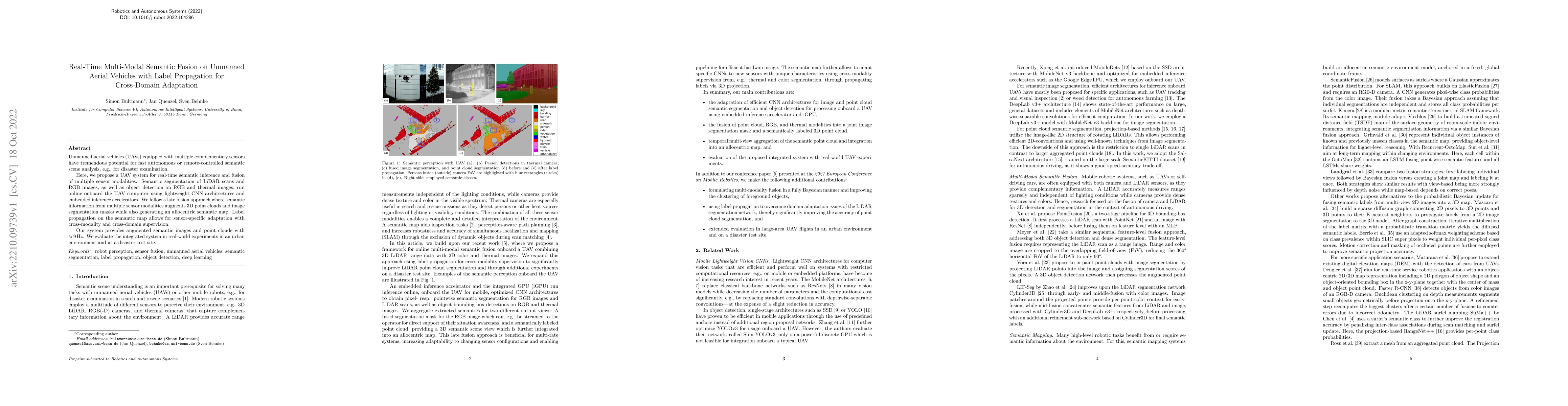
Unmanned aerial vehicles (UAVs) equipped with multiple complementary sensors have tremendous potential for fast autonomous or remote-controlled semantic scene analysis, e.g., for disaster examination. Here, we propose a UAV system for real-time semantic inference and fusion of multiple sensor modalities. Semantic segmentation of LiDAR scans and RGB images, as well as object detection on RGB and thermal images, run online onboard the UAV computer using lightweight CNN architectures and embedded inference accelerators. We follow a late fusion approach where semantic information from multiple sensor modalities augments 3D point clouds and image segmentation masks while also generating an allocentric semantic map. Label propagation on the semantic map allows for sensor-specific adaptation with cross-modality and cross-domain supervision. Our system provides augmented semantic images and point clouds with $\approx$ 9 Hz. We evaluate the integrated system in real-world experiments in an urban environment and at a disaster test site.
AI Key Findings - Failed
Key findings generation failed. Failed to start generation process
Paper Details
PDF Preview
Key Terms
Citation Network
Current paper (gray), citations (green), references (blue)
Display is limited for performance on very large graphs.
Similar Papers
Found 4 papersCross-modal Learning for Domain Adaptation in 3D Semantic Segmentation
Patrick Pérez, Tuan-Hung Vu, Raoul de Charette et al.
TUNI: Real-time RGB-T Semantic Segmentation with Unified Multi-Modal Feature Extraction and Cross-Modal Feature Fusion
Tong Liu, Xiaodong Guo, Zhihong Deng et al.
| Title | Authors | Year | Actions |
|---|
Comments (0)