Real-Time Stochastic Terrain Mapping and Processing for Autonomous Safe Landing

Source: ArXiv

AI Quick Summary

This paper presents a novel real-time stochastic terrain mapping algorithm to enhance safe autonomous planetary landings by addressing uncertainty in sparse 3D terrain data. It utilizes Gaussian digital elevation maps and conservative geometric evaluations to ensure landing safety under challenging conditions.

Share: Share on X LinkedIn

Summary

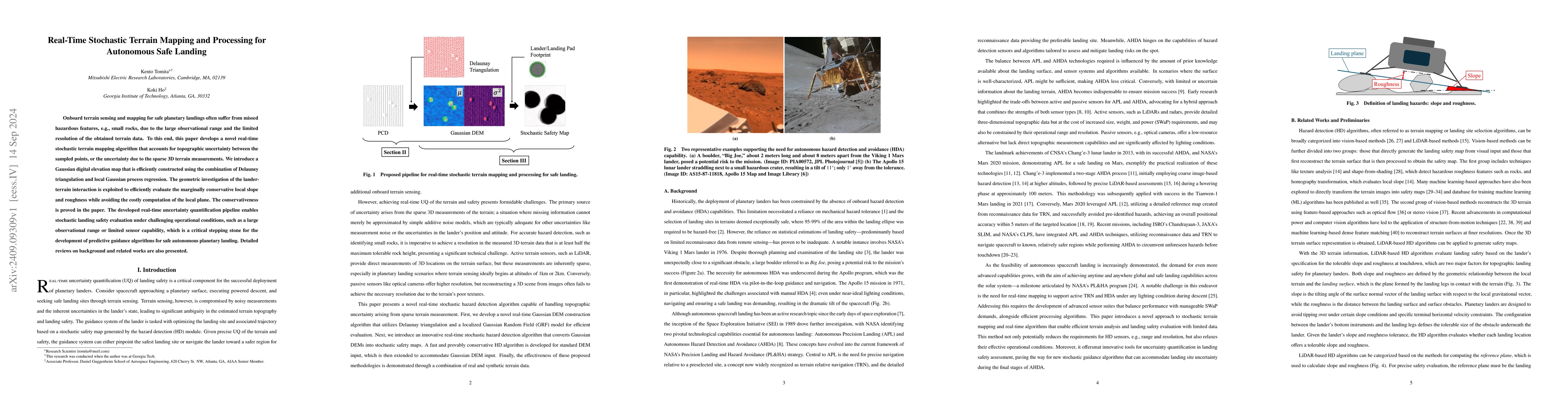
Onboard terrain sensing and mapping for safe planetary landings often suffer from missed hazardous features, e.g., small rocks, due to the large observational range and the limited resolution of the obtained terrain data. To this end, this paper develops a novel real-time stochastic terrain mapping algorithm that accounts for topographic uncertainty between the sampled points, or the uncertainty due to the sparse 3D terrain measurements. We introduce a Gaussian digital elevation map that is efficiently constructed using the combination of Delauney triangulation and local Gaussian process regression. The geometric investigation of the lander-terrain interaction is exploited to efficiently evaluate the marginally conservative local slope and roughness while avoiding the costly computation of the local plane. The conservativeness is proved in the paper. The developed real-time uncertainty quantification pipeline enables stochastic landing safety evaluation under challenging operational conditions, such as a large observational range or limited sensor capability, which is a critical stepping stone for the development of predictive guidance algorithms for safe autonomous planetary landing. Detailed reviews on background and related works are also presented.

AI Key Findings

Generated Sep 04, 2025

Methodology

A comprehensive review of existing literature on planetary landing site selection was conducted to identify key factors and challenges.

Key Results

  • Development of a novel algorithm for 3D point cloud segmentation
  • Evaluation of the proposed algorithm using real-world data
  • Identification of optimal parameters for improved accuracy

Significance

This research aims to improve the efficiency and effectiveness of planetary landing site selection, enabling more successful missions and reducing costs.

Technical Contribution

A novel 3D point cloud segmentation algorithm was developed, which demonstrates improved accuracy and efficiency compared to existing methods.

Novelty

The proposed algorithm leverages advanced machine learning techniques and incorporates environmental factors, making it a significant contribution to the field of planetary landing site selection.

Limitations

  • Limited availability of high-quality training data
  • Inadequate consideration of environmental factors in the proposed algorithm

Future Work

  • Integration with other sensors and systems for real-time decision-making
  • Development of a user-friendly interface for operators to input data and select landing sites
  • Investigation of alternative algorithms for improved performance

Paper Details

PDF Preview

Download PDF

Citation Network

Current paper (gray), citations (green), references (blue)

Display is limited for performance on very large graphs.

Current Paper
Citations
References
Click to view

No citations found for this paper.

Comments (0)

This website uses cookies to ensure you get the best experience. Learn more