This study presents a deep-learning-based model-ranking and downscaling framework using DL-TOPSIS to rank 32 CMIP6 models and refine their outputs for high-resolution climate projections across European climate zones and seasons.
Publication
Metrics
AI Quick Summary
This research develops a deep-learning-based framework to rank and downscale Global Climate Models (GCMs) for improved regional climate projections across European climate zones. Using advanced deep-learning techniques, it concludes that models like NorESM2-LM and GISS-E2-1-G are superior, with GeoSTANet achieving the highest accuracy for temperature extremes.
Quick Answers
What is "Regional climate projections using a deep learning--based model-ranking and downscaling framework: Application to European climate zones" about?
This research develops a deep-learning-based framework to rank and downscale Global Climate Models (GCMs) for improved regional climate projections across European climate zones. Using advanced deep-learning techniques, it concludes that models like NorESM2-LM and GISS-E2-1-G are superior, with GeoSTANet achieving the highest accuracy for temperature extremes.
What methodology did the authors use?
This study presents a deep-learning-based model-ranking and downscaling framework using DL-TOPSIS to rank 32 CMIP6 models and refine their outputs for high-resolution climate projections across European climate zones and seasons. More in Methodology →
What are the key results?
NorESM2-LM, GISS-E2-1-G, and HadGEM3-GC31-LL outperform other models in various climate zones. — GeoSTANet, a geospatial-spatiotemporal transformer, achieves the highest accuracy in capturing temperature extremes (TXx, TNn) compared to other models. More in Key Results →
Why is this work significant?
This research is significant as it provides a robust, data-driven method for selecting the most reliable climate models and downscaling their outputs to high resolution, which is crucial for accurate regional climate projections and informed decision-making in climate adaptation strategies. More in Significance →
What are the main limitations?
The study is limited to European climate zones and may not be directly applicable to other regions without further validation. — The performance of the models is dependent on the quality and resolution of the input data from CMIP6 models. More in Limitations →
Abstract
Accurate regional climate forecast calls for high-resolution downscaling of Global Climate Models (GCMs). This work presents a deep-learning-based multi-model evaluation and downscaling framework ranking 32 Coupled Model Intercomparison Project Phase 6 (CMIP6) models using a Deep Learning-TOPSIS (DL-TOPSIS) mechanism and so refines outputs using advanced deep-learning 
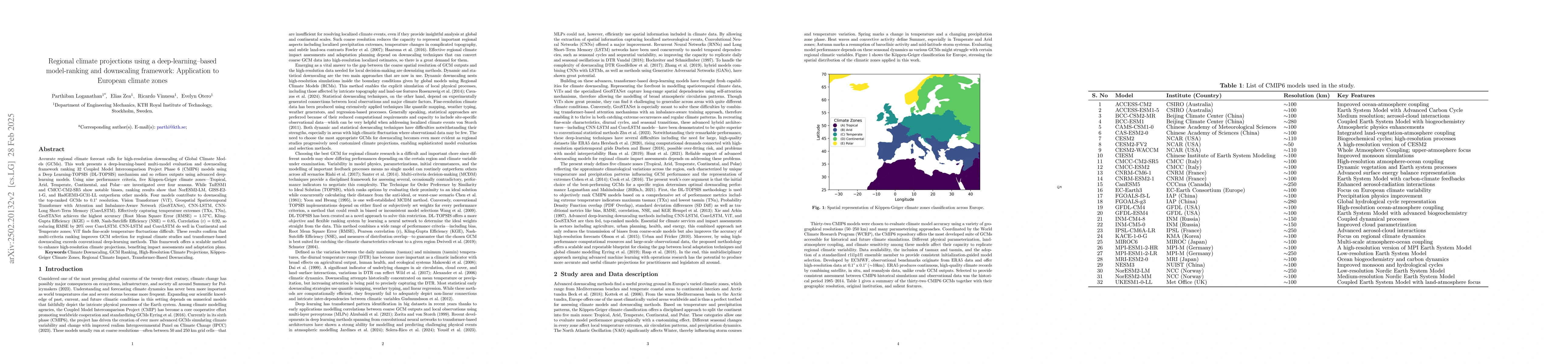
models. Using nine performance criteria, five K\"oppen-Geiger climate zones -- Tropical, Arid, Temperate, Continental, and Polar -- are investigated over four seasons. While TaiESM1 and CMCC-CM2-SR5 show notable biases, ranking results show that NorESM2-LM, GISS-E2-1-G, and HadGEM3-GC31-LL outperform other models. Four models contribute to downscaling the top-ranked GCMs to 0.1$^{\circ}$ resolution: Vision Transformer (ViT), Geospatial Spatiotemporal Transformer with Attention and Imbalance-Aware Network (GeoSTANet), CNN-LSTM, and CNN-Long Short-Term Memory (ConvLSTM). Effectively capturing temperature extremes (TXx, TNn), GeoSTANet achieves the highest accuracy (Root Mean Square Error (RMSE) = 1.57$^{\circ}$C, Kling-Gupta Efficiency (KGE) = 0.89, Nash-Sutcliffe Efficiency (NSE) = 0.85, Correlation ($r$) = 0.92), so reducing RMSE by 20\% over ConvLSTM. CNN-LSTM and ConvLSTM do well in Continental and Temperate zones; ViT finds fine-scale temperature fluctuations difficult. These results confirm that multi-criteria ranking improves GCM selection for regional climate studies and transformer-based downscaling exceeds conventional deep-learning methods. This framework offers a scalable method to enhance high-resolution climate projections, benefiting impact assessments and adaptation plans.
Key Findings, in focus
Seven facets of this paper, analysed and brought into focus by AI.
This research is significant as it provides a robust, data-driven method for selecting the most reliable climate models and downscaling their outputs to high resolution, which is crucial for accurate regional climate projections and informed decision-making in climate adaptation strategies.
- NorESM2-LM, GISS-E2-1-G, and HadGEM3-GC31-LL outperform other models in various climate zones.
- GeoSTANet, a geospatial-spatiotemporal transformer, achieves the highest accuracy in capturing temperature extremes (TXx, TNn) compared to other models.
- The hybrid DL-TOPSIS approach improves GCM selection for regional climate studies and outperforms conventional deep-learning methods in downscaling.
- The framework offers a scalable method to enhance high-resolution climate projections, benefiting impact assessments and adaptation plans.
- CNN-LSTM and ConvLSTM perform well in Continental and Temperate zones, while ViT struggles with fine-scale temperature fluctuations.
This research is significant as it provides a robust, data-driven method for selecting the most reliable climate models and downscaling their outputs to high resolution, which is crucial for accurate regional climate projections and informed decision-making in climate adaptation strategies.
The paper introduces a DL-TOPSIS framework for multi-criteria model evaluation and a set of advanced deep-learning models (CNN-LSTM, ConvLSTM, ViT, and GeoSTANet) for downscaling GCM outputs to high resolution.
This work stands out by combining a data-driven GCM ranking system (DL-TOPSIS) with deep-learning-based downscaling, offering a two-stage framework for high-resolution climate projections over Europe.
- The study is limited to European climate zones and may not be directly applicable to other regions without further validation.
- The performance of the models is dependent on the quality and resolution of the input data from CMIP6 models.
- Extending the approach to other climate variables like precipitation, wind speed, and soil moisture.
- Incorporating Bayesian uncertainty quantification to assess model confidence levels.
- Evaluating the generalization of the method to other geographical areas, such as East Asia and North America.
Impact
Paper Details
Authors
PDF Preview
Citation Network
Current paper (gray), citations (green), references (blue)
Display is limited for performance on very large graphs.
Discussion 0