Regionalization of Multiscale Spatial Processes using a Criterion for Spatial Aggregation Error
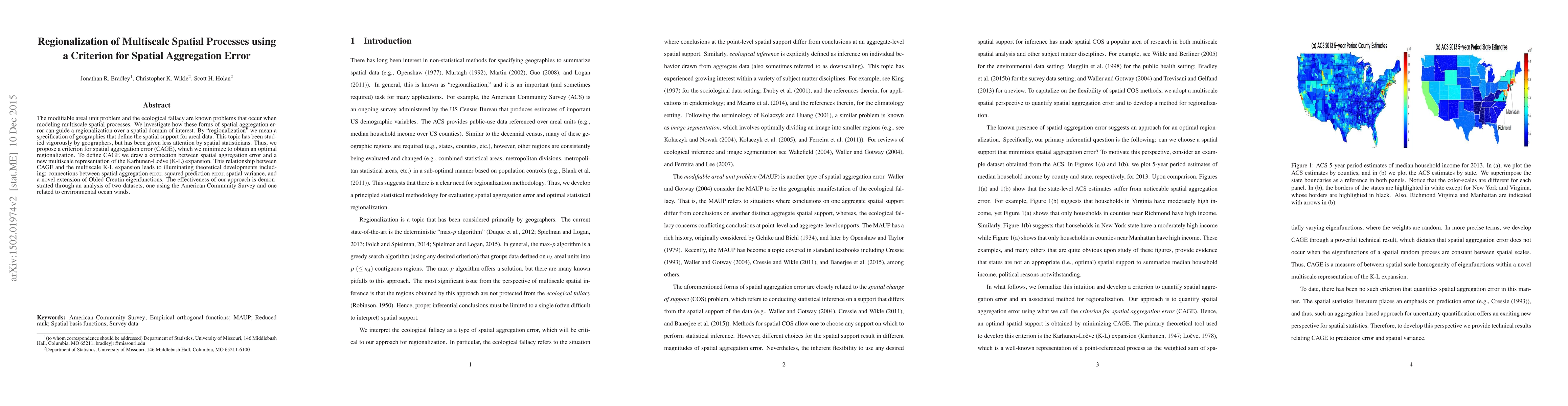
Publication
Metrics
AI Quick Summary
This paper proposes a criterion for spatial aggregation error (CAGE) to minimize regionalization errors in multiscale spatial processes, addressing the modifiable areal unit problem and the ecological fallacy. It connects CAGE with a multiscale Karhunen-Loeve expansion, leading to theoretical insights and demonstrated through analyses of American Community Survey and environmental ocean wind datasets.
Paper Preview
Abstract
The modifiable areal unit problem and the ecological fallacy are known problems that occur when modeling multiscale spatial processes. We investigate how these forms of spatial aggregation error can guide a regionalization over a spatial domain of interest. By "regionalization" we mean a specification of geographies that define the spatial support for areal data. This topic has been studied vigorously by geographers, but has been given less attention by spatial statisticians. Thus, we propose a criterion for spatial aggregation error (CAGE), which we minimize to obtain an optimal regionalization. To define CAGE we draw a connection between spatial aggregation error and a new multiscale representation of the Karhunen-Loeve (K-L) expansion. This relationship between CAGE and the multiscale K-L expansion leads to illuminating theoretical developments including: connections between spatial aggregation error, squared prediction error, spatial variance, and a novel extension of Obled-Creutin eigenfunctions. The effectiveness of our approach is demonstrated through an analysis of two datasets, one using the American Community Survey and one related to environmental ocean winds.
AI Key Findings — Failed
Key findings generation failed. Failed to start generation process
Impact
Paper Details
PDF Preview
Key Terms
Citation Network
Current paper (gray), citations (green), references (blue)
Display is limited for performance on very large graphs.
Discussion 0