Background
Geospatial reasoning in remote sensing requires translating fuzzy, user-centric spatial intents into precise target locations. Prior work in this space has progressed from pixel-level reasoning to multi-granularity analysis but remains tethered to ground-truth coordinate supervision. Systems like SegEarth-R1 and RemoteReasoner established RL-like workflows for geo-reasoning, yet their optimization rested on externally labeled coordinates (IoU-based rewards) to measure localization accuracy, constraining true self-evolution on unlabeled data. The field increasingly relies on multimodal large language models (MLLMs) to fuse image understanding with textual queries, but grounding still hinges on labeled geometric supervision, limiting scalability across petabytes of unlabeled imagery.
Problem / Research Question
The core question asks whether one can dismantle the dependency on external box annotations for geospatial localization without sacrificing performance. Specifically, can intrinsic semantic verification—leveraging an MLLM’s stronger discriminative ability to judge “does this region semantically satisfy the query?”—replace explicit coordinate supervision and still drive robust spatial grounding through autonomous training and self-evolution?
Innovation / Contribution
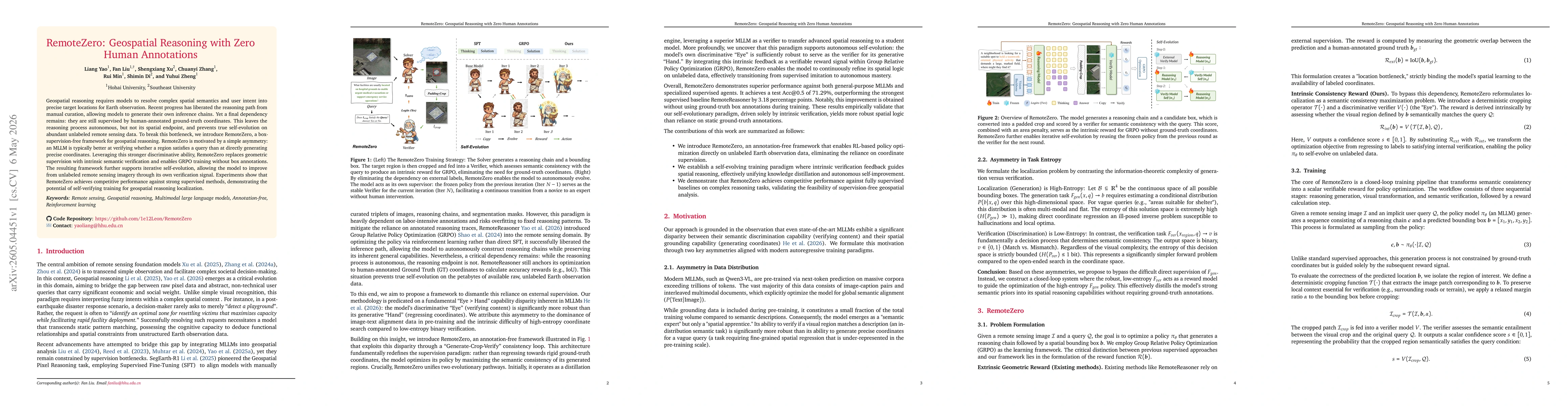
RemoteZero introduces a box-supervision-free framework that reframes localization as semantic consistency maximization. The central insight is the Eye > Hand disparity: MLLMs are more reliable at verification than at coordinate regression due to pretraining emphasis on image-text alignment. The architecture replaces Fgen-based supervision with an intrinsic reward derived from a Verifier V that judges whether a cropped region matches the query Q. The policy πθ generates a reasoning chain and a candidate box; a cropping operator 𝒯 preserves context by adding a margin α; the verifier scores the crop, and the area penalty ensures boxes remain targeted. This intrinsic reward propels GRPO optimization without ground-truth coordinates. A key feature is iterative self-evolution: the model from the previous round serves as the verifier for the current round, enabling bootstrapped improvement on unlabeled data.
Methodology / Approach
The framework follows a Generate-Crop-Verify loop within Group Relative Policy Optimization. Given an image I and a query Q, the policy πθ outputs a reasoning chain c and a bounding box b = [x1,y1,x2,y2]. A cropping operator 𝒯 extracts a patch corresponding to b with a margin α to maintain contextual cues. The Verifier V assesses semantic entailment between the patch and Q, producing a score s in [0,1]. The reward r combines s with an area penalty that discourages oversized crops; a threshold τ controls acceptable area proportion. These rewards drive the GRPO update, using the verification signal instead of external coordinate labels, enabling training on unlabeled Earth observation data. While a powerful external verifier (e.g., a larger model like Qwen3-VL-32B) can improve supervision, the framework does not require it to be valid. The Eye–Hand asymmetry thus becomes a practical training signal for spatial grounding, and the previous-round verifier enables self-evolution without ground-truth coordinates.
Experiments / Evaluation
The evaluation focuses on geospatial reasoning under intrinsic supervision and autonomous self-evolution. Baselines include general-purpose MLLMs (e.g., Qwen2.5-VL-7B, DeepSeek variants) and specialized remote-sensing models (GeoChat, RemoteReasoner). With an external verifier, RemoteZero achieves 65.05% test [email protected] without box supervision for policy optimization. After iterative self-evolution, performance improves to 71.29% [email protected], surpassing the strongest supervised baseline RemoteReasoner by 3.18 percentage points. The results also show that removing ground-truth coordinates is feasible, though the localization accuracy (gIoU) lags behind, indicating the reward emphasizes semantic correctness more than tight boundary calibration. Ablation studies reveal that adding an area-penalty term boosts accuracy from 65.20% to 69.96% and that strict cropping reduces performance, underscoring the importance of local context for verification. The experiments are conducted on EarthReason, with reported training settings (e.g., 10 epochs, learning rate 5e-6, batch size 6 per device, gradient accumulation 8).
Key Results
RemoteZero demonstrates competitive performance against fully supervised baselines without coordinate supervision. The best reported result after self-evolution is 71.29% [email protected], closing the gap to supervised methods and offering a clear demonstration that intrinsic semantic verification can drive effective geospatial localization. The framework also highlights trade-offs: semantic verification offers robust region-level alignment, whereas precise boundary calibration (gIoU) remains challenging under annotation-free training. The results validate the core hypothesis that “verification-first” supervision can unlock autonomous improvement on unlabeled earth imagery.
Practical Applications
RemoteZero makes large-scale geospatial reasoning feasible with minimal labeling cost, enabling applications in disaster response, evacuation planning, urban development, and environmental monitoring where rapid localization from vague queries is essential. The approach is particularly attractive for time-sensitive tasks (e.g., post-disaster assessment) where curated ground-truth coordinates are scarce or outdated. It also suggests a scalable paradigm for remote sensing AI: leverage the strong semantic understanding of MLLMs to guide spatial grounding, then progressively refine through self-evolution on abundant unlabeled data, reducing dependence on costly annotations.
Limitations & Considerations
While compelling, the approach hinges on the verifier’s reliability. The current reward emphasizes semantic correctness over precise geometry, which can yield coarse localizations. Iterative self-evolution may propagate biases from the previous verifier, and crop-based verification might miss global spatial relations or long-range context. Additional limitations include dependence on the availability and quality of the Verifier (external or prior-round) and sensitivity to hyperparameters like α (context margin), λ (area penalty), and τ (area threshold). Future work should address stronger global-local verification, robust negative mining, and stable, long-horizon self-evolution strategies to improve both robustness and localization precision.
Discussion 0