Publication
Metrics
AI Quick Summary
This study introduces a new accessibility measure based on the spatial distribution of urban Points of Interest, employing the radial distribution function to analyze service dispersion across city zones. It identifies core, secondary cores, and periphery areas, revealing patterns of spatial inequality and socioeconomic disparities in access to urban amenities.
Paper Preview
Abstract
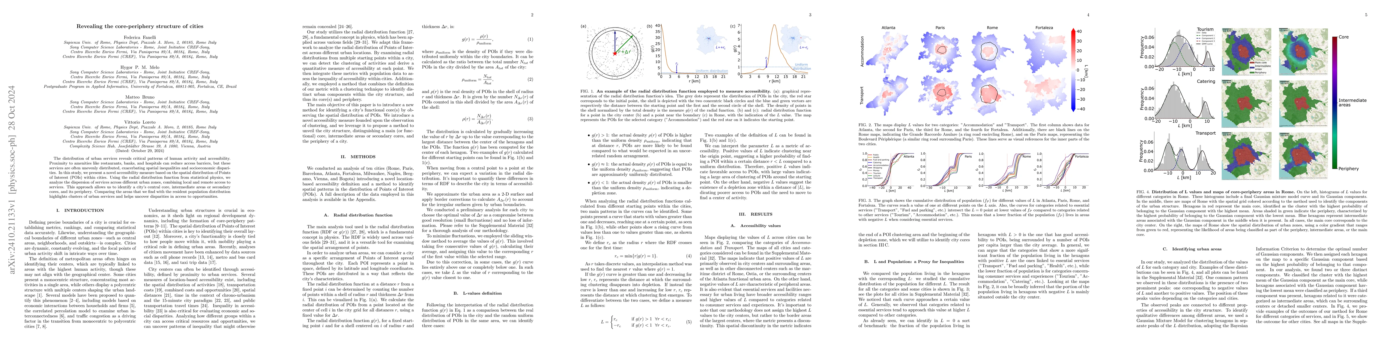
The distribution of urban services reveals critical patterns of human activity and accessibility. Proximity to amenities like restaurants, banks, and hospitals can reduce access barriers, but these services are often unevenly distributed, exacerbating spatial inequalities and socioeconomic disparities. In this study, we present a novel accessibility measure based on the spatial distribution of Points of Interest (POIs) within cities. Using the radial distribution function from statistical physics, we analyze the dispersion of services across different urban zones, combining local and remote access to services. This approach allows us to identify a city's central core, intermediate areas or secondary cores, and its periphery. Comparing the areas that we find with the resident population distribution highlights clusters of urban services and helps uncover disparities in access to opportunities.
AI Key Findings
Get AI-generated insights about this paper's methodology, results, significance, and more — seven facets brought into focus.
Impact
Paper Details
Authors
PDF Preview
Citation Network
Current paper (gray), citations (green), references (blue)
Display is limited for performance on very large graphs.
Discussion 0