ArxivLens
ArXiv cs.CV

Revisiting Aerial Scene Classification on the AID Benchmark

Abhiroop Chatterjee, Subhajeet Das, Susmita Ghosh

2601.18263 Published Jan 26, 2026
View PDF

Publication

Published: Jan 26, 2026
Categories: cs.CV

Metrics

Source: ArXiv

Quick Answers

What methodology did the authors use?

The study conducts a literature review of machine learning methods for aerial image classification, including handcrafted features, traditional CNNs, and advanced deep hybrid networks. It proposes Aerial-Y-Net, a spatial attention-enhanced CNN with multi-scale feature fusion, and evaluates it on the AID dataset. More in Methodology →

What are the key results?

Aerial-Y-Net achieved 91.72% accuracy on the AID dataset, outperforming several baseline architectures. — MILRDA achieved 95.46% accuracy, LmNet achieved 97.12% accuracy, and SE-MDPMNet achieved 97.14% accuracy. More in Key Results →

Why is this work significant?

This research advances aerial scene classification by proposing an attention-based model that improves accuracy and provides insights into handling complex aerial image data for urban planning and environmental monitoring. More in Significance →

What are the main limitations?

The model struggles to distinguish visually similar classes with overlapping background features. — The study focuses on the AID dataset, limiting generalizability to other aerial image datasets. More in Limitations →

Paper Preview

Abstract

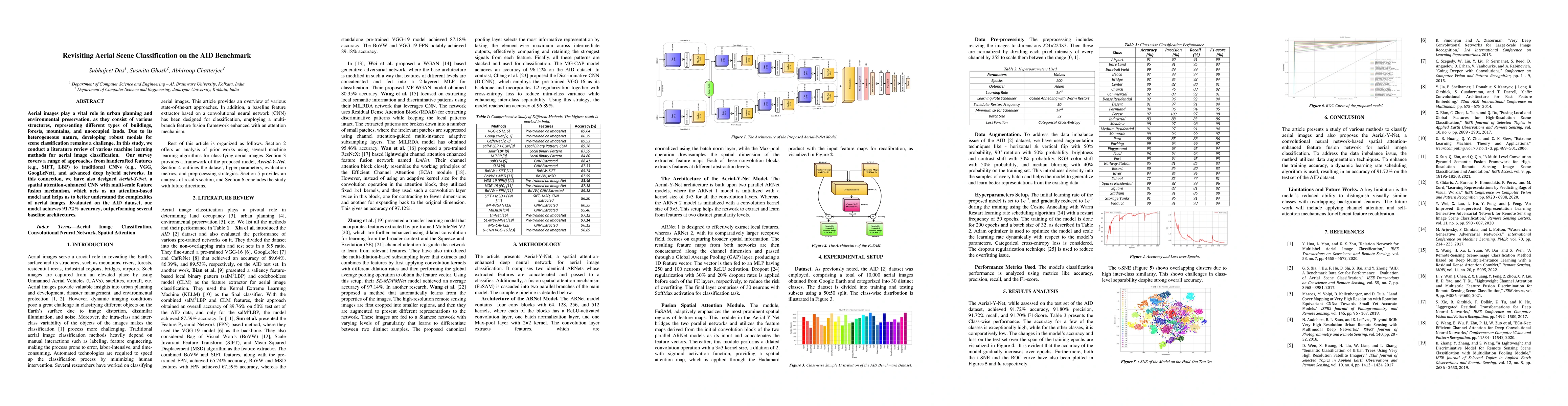
Aerial images play a vital role in urban planning and environmental preservation, as they consist of various structures, representing different types of buildings, forests, mountains, and unoccupied lands. Due to its heterogeneous nature, developing robust models for scene classification remains a challenge. In this study, we conduct a literature review of various machine learning methods for aerial image classification. Our survey covers a range of approaches from handcrafted features (e.g., SIFT, LBP) to traditional CNNs (e.g., VGG, GoogLeNet), and advanced deep hybrid networks. In this connection, we have also designed Aerial-Y-Net, a spatial attention-enhanced CNN with multi-scale feature fusion mechanism, which acts as an attention-based model and helps us to better understand the complexities of aerial images. Evaluated on the AID dataset, our model achieves 91.72% accuracy, outperforming several baseline architectures.

Key Findings, in focus

Seven facets of this paper, analysed and brought into focus by AI.

AI-generated · verify against source Generated Jan 27, 2026
In focus · one-line synthesis

This research advances aerial scene classification by proposing an attention-based model that improves accuracy and provides insights into handling complex aerial image data for urban planning and environmental monitoring.

01
MethodologyHow they did it

The study conducts a literature review of machine learning methods for aerial image classification, including handcrafted features, traditional CNNs, and advanced deep hybrid networks. It proposes Aerial-Y-Net, a spatial attention-enhanced CNN with multi-scale feature fusion, and evaluates it on the AID dataset.

02
ResultsWhat they found
  • Aerial-Y-Net achieved 91.72% accuracy on the AID dataset, outperforming several baseline architectures.
  • MILRDA achieved 95.46% accuracy, LmNet achieved 97.12% accuracy, and SE-MDPMNet achieved 97.14% accuracy.
  • The proposed model showed strong overall performance but had challenges in distinguishing visually similar classes with overlapping backgrounds.
03
SignificanceWhy it matters

This research advances aerial scene classification by proposing an attention-based model that improves accuracy and provides insights into handling complex aerial image data for urban planning and environmental monitoring.

04
Technical ContributionsWhat's new technically

Development of Aerial-Y-Net, a spatial attention-enhanced CNN with multi-scale feature fusion mechanism for aerial image classification.

05
NoveltyWhat sets it apart

Integration of spatial attention and multi-scale feature fusion in a CNN architecture specifically tailored for aerial image classification tasks.

06
LimitationsWhat to be cautious about
  • The model struggles to distinguish visually similar classes with overlapping background features.
  • The study focuses on the AID dataset, limiting generalizability to other aerial image datasets.
07
Future WorkWhere it goes next
  • Applying channel attention and self-attention mechanisms for efficient feature recalibration.
  • Exploring more diverse datasets to improve generalizability of the model.

Paper Details

Paper ID: 2601.18263
Comments: Presented at the IEEE India Geoscience and Remote Sensing Symposium 2025 and accepted for publication in IEEE Xplore
Categories:
cs.CV

How to Cite This Paper

Reference manager: RIS EndNote


Discussion 0

This website uses cookies to ensure you get the best experience. Learn more