Quick Answers
What methodology did the authors use?
Hardware-software co-design on an AMD Zynq RFSoC platform implementing two synchronized receiver channels to capture direct and ground-reflected NavIC signals, processed on ARM and FPGA to generate delay-Doppler maps in real time. More in Methodology →
What are the key results?
Successful delay-Doppler map generation in both loopback and AWG-emulated configurations, detecting targets at SNRs as low as -12 dB. — Achieved range and Doppler estimation RMSE of 0.14 km and 250 Hz respectively, within the system’s resolution limits. More in Key Results →
Why is this work significant?
Demonstrates a compact, scalable, and low-power passive GNSS remote sensing system suitable for UAV-based surveillance, enabling cost-effective spectrum reuse and real-time target detection. More in Significance →
What are the main limitations?
No link-budget analysis for highly attenuated satellite signals; performance on real NavIC signals not yet evaluated. — Prototype lacks an analog front-end, limiting direct reception of actual satellite signals. More in Limitations →
Abstract
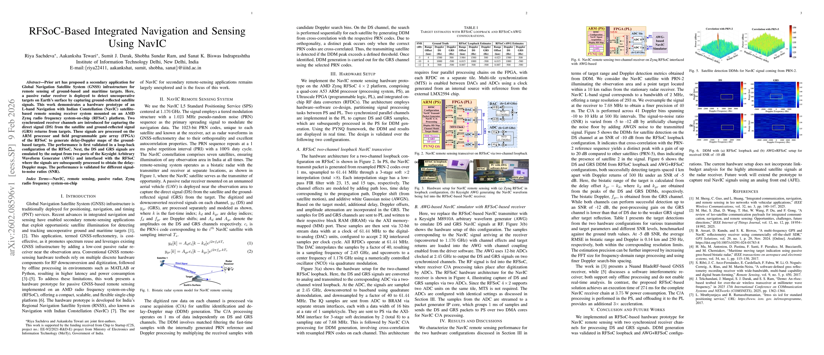
Prior art has proposed a secondary application for Global Navigation Satellite System (GNSS) infrastructure for remote sensing of ground-based and maritime targets. Here, a passive radar receiver is deployed to detect uncooperative targets on Earth's surface by capturing ground-reflected satellite signals. This work demonstrates a hardware prototype of an L-band Navigation with Indian Constellation (NavIC) satellite-based remote sensing receiver system mounted on an AMD Zynq radio frequency system-on-chip (RFSoC) platform. Two synchronized receiver channels are introduced for capturing the direct signal (DS) from the satellite and ground-reflected signal (GRS) returns from targets. These signals are processed on the ARM processor and field programmable gate array (FPGA) of the RFSoC to generate delay-Doppler maps of the ground-based targets. The performance is first validated in a loop-back configuration of the RFSoC. Next, the DS and GRS signals are emulated by the output from two ports of the Keysight Arbitrary Waveform Generator (AWG) and interfaced with the RFSoC where the signals are subsequently processed to obtain the delay-Doppler maps. The performance is validated for different signal-to-noise ratios (SNR).
AI Key Findings
Generated Feb 10, 2026
Methodology — What approach did the authors take?
Hardware-software co-design on an AMD Zynq RFSoC platform implementing two synchronized receiver channels to capture direct and ground-reflected NavIC signals, processed on ARM and FPGA to generate delay-Doppler maps in real time.
Key Results — What are the main findings?
- Successful delay-Doppler map generation in both loopback and AWG-emulated configurations, detecting targets at SNRs as low as -12 dB.
- Achieved range and Doppler estimation RMSE of 0.14 km and 250 Hz respectively, within the system’s resolution limits.
- Real-time processing completed in 274 ms with a power consumption of 3.75 W, outperforming prior offline solutions.
Significance — Why does this research matter?
Demonstrates a compact, scalable, and low-power passive GNSS remote sensing system suitable for UAV-based surveillance, enabling cost-effective spectrum reuse and real-time target detection.
Technical Contribution — What is the technical contribution?
First RFSoC-based hardware prototype for NavIC passive radar remote sensing with real-time delay-Doppler map generation via hardware-software co-design.
Novelty — What is new about this work?
Combines NavIC passive radar with a dual-channel synchronized RFSoC receiver, enabling real-time processing and compact deployment, unlike prior offline or multi-component solutions.
Limitations — What are the limitations of this study?
- No link-budget analysis for highly attenuated satellite signals; performance on real NavIC signals not yet evaluated.
- Prototype lacks an analog front-end, limiting direct reception of actual satellite signals.
Future Work — What did the authors propose for future work?
- Integrate an analog front-end to capture real NavIC signals and perform link-budget analysis.
- Extend the system to multi-frequency operation and improve resolution through larger FFTs and finer Doppler binning.
How to Cite This Paper
@article{tewari2026rfsoc,
title = {RFSoC-Based Integrated Navigation and Sensing Using NavIC},
author = {Tewari, Aakanksha and Sachdeva, Riya and Biswas, Sanat K. and others},
year = {2026},
eprint = {2602.08596},
archivePrefix = {arXiv},
primaryClass = {eess.SP},
}
Tewari, A., Sachdeva, R., Biswas, S., Ram, S., & Darak, S. (2026). RFSoC-Based Integrated Navigation and Sensing Using NavIC. arXiv. https://arxiv.org/abs/2602.08596
Tewari, Aakanksha, et al. "RFSoC-Based Integrated Navigation and Sensing Using NavIC." arXiv, 2026, arxiv.org/abs/2602.08596.
PDF Preview
Similar Papers
Found 4 papersOptical flow GNSS for navigation in the Indian subcontinent (NavIC)
Sunit Shantanu Digamber Fulari
Integrated Communication, Navigation, and Remote Sensing in LEO Networks with Vehicular Applications
Min Sheng, Chongtao Guo, Lei Huang
An AFDM-Based Integrated Sensing and Communications
Peng Yuan, Yuanhan Ni, Zulin Wang et al.
Study of Low-latitude Ionospheric Scintillation using NavIC
Sumanjit Chakraborty, Abhirup Datta
Comments (0)