ArxivLens

Quick Summary:

The paper proposes RiFCN, a bidirectional recurrent network within a fully convolutional framework, to enhance semantic segmentation of high-resolution remote sensing images by recursively fusing multi-level feature maps for accurate boundary inference and detailed segmentation. Experimental results show competitive performance on ISPRS Potsdam and Inria datasets.

arXiv Id: 1805.02091
Date Published: 2018-05-08
Date Updated: 2018-05-08

Categories:

Key Terms (TF-IDF):

semantic segmentation (0.218)
convolutional (0.214)
segmentation (0.203)
remote sensing (0.197)
high level (0.192)
semantic (0.182)
remote (0.168)
maps (0.167)
high resolution (0.166)
feature (0.159)
shallow (0.153)
multi level (0.153)
sensing (0.151)
resolution (0.146)
stream (0.142)
level (0.140)
layers (0.140)
network (0.123)
takes (0.119)
high (0.117)
License: http://arxiv.org/licenses/nonexclusive-distrib/1.0/

Summary:

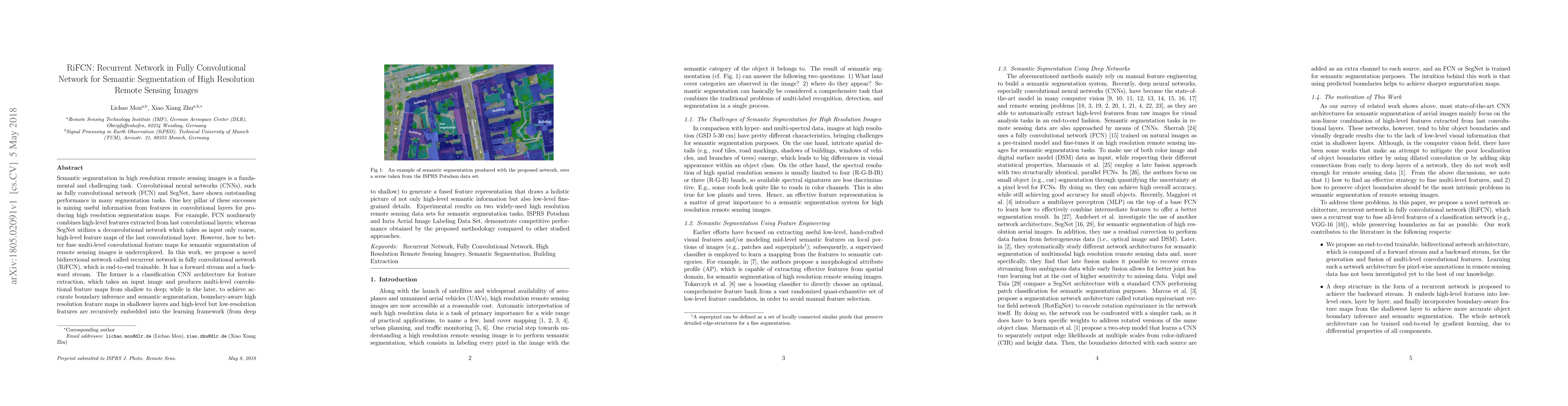
Semantic segmentation in high resolution remote sensing images is a fundamental and challenging task. Convolutional neural networks (CNNs), such as fully convolutional network (FCN) and SegNet, have shown outstanding performance in many segmentation tasks. One key pillar of these successes is mining useful information from features in convolutional layers for producing high resolution segmentation maps. For example, FCN nonlinearly combines high-level features extracted from last convolutional layers; whereas SegNet utilizes a deconvolutional network which takes as input only coarse, high-level feature maps of the last convolutional layer. However, how to better fuse multi-level convolutional feature maps for semantic segmentation of remote sensing images is underexplored. In this work, we propose a novel bidirectional network called recurrent network in fully convolutional network (RiFCN), which is end-to-end trainable. It has a forward stream and a backward stream. The former is a classification CNN architecture for feature extraction, which takes an input image and produces multi-level convolutional feature maps from shallow to deep; while in the later, to achieve accurate boundary inference and semantic segmentation, boundary-aware high resolution feature maps in shallower layers and high-level but low-resolution features are recursively embedded into the learning framework (from deep to shallow) to generate a fused feature representation that draws a holistic picture of not only high-level semantic information but also low-level fine-grained details. Experimental results on two widely-used high resolution remote sensing data sets for semantic segmentation tasks, ISPRS Potsdam and Inria Aerial Image Labeling Data Set, demonstrate competitive performance obtained by the proposed methodology compared to other studied approaches.

Citation & Reference Network Visualization

This graph shows how this paper is connected to other research. The current paper is shown in dark gray, papers that cite it are in green, and papers it references are in blue. You can:

Current Paper
Papers citing this work (Citations)
Papers cited by this work (References)

• Hover over any node to see the paper title

• Click a node to view that paper's details

• Drag nodes to rearrange the graph

• Use the zoom controls (bottom right) to zoom in/out

Citations and References

Title Authors Year Actions
Deep Learning-Based Methods for Road Extraction From Remote Sensing Images: A vision, survey, and future directions
Xuan Wang, Xizhi Jin, Zhe Dai, Yuxuan Wu, A. Chehri
2025
View Paper
Man-made object segmentation around reservoirs by an end-to-end two-phase deep learning-based workflow
Nayereh Hamidishad, R. M. Cesar
2024
View Paper
Geometric Boundary Guided Feature Fusion and Spatial-Semantic Context Aggregation for Semantic Segmentation of Remote Sensing Images
Yupei Wang, Haoran Zhang, Yongkang Hu, Xiaoxing Hu, Liang Chen, Shanqing Hu
2023
View Paper
HiT: Building Mapping With Hierarchical Transformers
Mingming Zhang, Qingjie Liu, Yunhong Wang
2023
View Paper
Extraction of maize planting area based on transformer and remote sensing data
Wei Lv, Xuan Song, Huan Yang
2023
View Paper
Fusion attention-ASPP and context semantic for complex scene semantic segmentation
Yinghao Lin, Shihao Zhao, K. Cai, Baojun Qiao
2023
View Paper
An End-to-End Two-Phase Deep Learning-Based workflow to Segment Man-made Objects Around Reservoirs
Nayereh Hamidishad, R. M. C. Junior
2023
View Paper
Optimizing Distributed Deep Learning in Heterogeneous Computing Platforms for Remote Sensing Data Classification
S. Moreno-Álvarez, Mercedes Eugenia Paoletti, Juan A. Rico, Gabriele Cavallaro, J. Haut
2022
View Paper
Mapping Roofing with Asbestos-Containing Material by Using Remote Sensing Imagery and Machine Learning-Based Image Classification: A State-of-the-Art Review
M. Abbasi, Sherif Mostafa, A. S. Vieira, Nicholas P. Patorniti, R. Stewart
2022
View Paper
Mining Cross-Domain Structure Affinity for Refined Building Segmentation in Weakly Supervised Constraints
Jun Zhang, Yue Liu, Pengfei Wu, Zhenwei Shi, Bin Pan
2022
View Paper
Semantic Segmentation of High-Resolution Remote Sensing Images Using Multiscale Skip Connection Network
Bifang Ma, Chih-Yung Chang
2022
View Paper
ME-Net: A Multi-Scale Erosion Network for Crisp Building Edge Detection from Very High Resolution Remote Sensing Imagery
Xiang Wen, Xing Li, Ce Zhang, Wenquan Han, Erzhu Li, Wei Liu, Lianpeng Zhang
2021
View Paper
DGFNet: Dual Gate Fusion Network for Land Cover Classification in Very High-Resolution Images
Yongjie Guo, Feng Wang, Yuming Xiang, H. You
2021
View Paper
Dual Attention Feature Fusion and Adaptive Context for Accurate Segmentation of Very High-Resolution Remote Sensing Images
Hao Shi, Jiahe Fan, Yupei Wang, Liang Chen
2021
View Paper
A real-time efficient object segmentation system based on U-Net using aerial drone images
Imran Ahmed, Misbah Ahmad, Gwanggil Jeon
2021
View Paper
CPISNet: Delving into Consistent Proposals of Instance Segmentation Network for High-Resolution Aerial Images
Xiangfeng Zeng, Shunjun Wei, Jinshan Wei, Zichen Zhou, Jun Shi, Xiaoling Zhang, Fan Fan
2021
View Paper
Unconstrained Aerial Scene Recognition with Deep Neural Networks and a New Dataset
Yuansheng Hua, Lichao Mou, P. Jin, Xiao Xiang Zhu
2021
View Paper
Multiple Incremental Kernel Convolution for Land Cover Classification of Remotely Sensed Images
X. Tao, L. Han, Mercedes Eugenia Paoletti, S. K. Roy, J. Plaza, J. Haut, A. Plaza
2021
View Paper
Comparing Deep Recurrent Learning and Convolutional Learning for Multi-Temporal Vegetation Classification
Khadidja Bakhti, Mohammed El Amin Larabi
2021
View Paper
Self-constructing graph neural networks to model long-range pixel dependencies for semantic segmentation of remote sensing images
Qinghui Liu, Michael C. Kampffmeyer, R. Jenssen, Arnt-Børre Salberg
2021
View Paper
Multiscale Building Extraction With Refined Attention Pyramid Networks
Qinglin Tian, Yingjun Zhao, Yao Li, Jun Chen, Xuejiao Chen, Kai Qin
2021
View Paper
High-resolution remote sensing image semantic segmentation based on a deep feature aggregation network
Zhen Wang, Jianxin Guo, Wenzhun Huang, Shanwen Zhang
2021
View Paper
Aerial scene understanding in the wild: Multi-scene recognition via prototype-based memory networks
Yuansheng Hua, Lichao Mou, Jianzhe Lin, Konrad Heidler, Xiaoxiang Zhu
2021
View Paper
MultiScene: A Large-Scale Dataset and Benchmark for Multiscene Recognition in Single Aerial Images
Yuansheng Hua, Lichao Mou, P. Jin, Xiaoxiang Zhu
2021
View Paper
Deep Learning-Based Semantic Segmentation of Urban Features in Satellite Images: A Review and Meta-Analysis
B. Neupane, T. Horanont, J. Aryal
2021
View Paper
C3Net: Cross-Modal Feature Recalibrated, Cross-Scale Semantic Aggregated and Compact Network for Semantic Segmentation of Multi-Modal High-Resolution Aerial Images
Zhiying Cao, W. Diao, Xian Sun, Xiaode Lyu, M. Yan, Kun Fu
2021
View Paper
Semantic Segmentation for Buildings of Large Intra-Class Variation in Remote Sensing Images with O-GAN
Shuting Sun, Lin Mu, Lizhe Wang, Peng Liu, Xiaolei Liu, Yuwei Zhang
2021
View Paper
HRCNet: High-Resolution Context Extraction Network for Semantic Segmentation of Remote Sensing Images
Zhiyong Xu, Weicun Zhang, Tianxiang Zhang, Jiangyun Li
2020
View Paper
A Cloud Detection Method Using Convolutional Neural Network Based on Gabor Transform and Attention Mechanism with Dark Channel Subnet for Remote Sensing Image
Jing Zhang, Qinye Zhou, Jun Wu, Yuchen Wang, Hui Wang, Yunsong Li, Yuzhou Chai, Yang Liu
2020
View Paper
Semantic segmentation and colorization of grayscale aerial imagery with W‐Net models
Maria Dias, João Monteiro, J. Estima, Joel Silva, Bruno Martins
2020
View Paper
Land Cover Classification From VHR Optical Remote Sensing Images by Feature Ensemble Deep Learning Network
S. Dong, Zhuang Yin, Zhanxin Yang, Long Pang, He Chen, Teng Long
2020
View Paper
FA-Net: feature attention network for semantic segmentation of ship port
Wei Xiong, Mi Cai, Yafei Lv, Jiazheng Pei
2020
View Paper
Building Extraction of Aerial Images by a Global and Multi-Scale Encoder-Decoder Network
Jingjing Ma, Linlin Wu, Xu Tang, Fang Liu, Xiangrong Zhang, L. Jiao
2020
View Paper
EANet: Edge-Aware Network for the Extraction of Buildings from Aerial Images
Guang Yang, Qian Zhang, Guixu Zhang
2020
View Paper
Postprocessing framework for land cover classification optimization based on iterative self-adaptive superpixel segmentation
Boce Chu, Jie Chen, Qianwen Guo, Feng Gao, Jinyong Chen, Shicheng Wang
2020
View Paper
Building extraction from VHR remote sensing imagery by combining an improved deep convolutional encoder-decoder architecture and historical land use vector map
Wenqing Feng, H. Sui, L. Hua, Chuan Xu, G. Ma, Weiming Huang
2020
View Paper
Identification of Partially Resolved Objects in Space Imagery with Convolutional Neural Networks
Christopher A. Ertl, John A. Christian
2020
View Paper
FRF-Net: Land Cover Classification From Large-Scale VHR Optical Remote Sensing Images
Qianbo Sang, Zhuang Yin, S. Dong, Guanqun Wang, He Chen
2020
View Paper
Deep Learning Methods for Land Cover and Land Use Classification in Remote Sensing: A Review
Abebaw Alem, Shailender Kumar
2020
View Paper
Research on Spatialization of Urban Area Based on Deep Learning
Ullah Inam, Weidong Li, F. Meng
2020
View Paper
Temporal information integration for video semantic segmentation
Guillaume Guarino, T. Chateau, Céline Teulière, Violaine Antoine
2020
View Paper
Relation Matters: Relational Context-Aware Fully Convolutional Network for Semantic Segmentation of High-Resolution Aerial Images
Lichao Mou, Yuansheng Hua, Xiaoxiang Zhu
2020
View Paper
Contextual Pyramid Attention Network for Building Segmentation in Aerial Imagery
Clint Sebastian, Raffaele Imbriaco, Egor Bondarev, P. D. With
2020
View Paper
An Improved Boundary-Aware Perceptual Loss for Building Extraction from VHR Images
Y. Zhang, Weihong Li, W. Gong, Zixu Wang, Jingxi Sun
2020
View Paper
Domain Adaptive Transfer Attack-Based Segmentation Networks for Building Extraction From Aerial Images
Younghwan Na, Jun Hee Kim, Kyungsu Lee, Juhum Park, J. Hwang, Jihwan P. Choi
2020
View Paper
Dense Dilated Convolutions’ Merging Network for Land Cover Classification
Qinghui Liu, Michael C. Kampffmeyer, R. Jenssen, Arnt-Børre Salberg
2020
View Paper
Deep Convolutional Neural Network-Based Robust Phase Gradient Estimation for Two-Dimensional Phase Unwrapping Using SAR Interferograms
Lifan Zhou, Hanwen Yu, Yang Lan
2020
View Paper
EU-Net: An Efficient Fully Convolutional Network for Building Extraction from Optical Remote Sensing Images
Wenchao Kang, Yuming Xiang, Feng Wang, H. You
2019
View Paper
Accurate Object Detection Based on Faster R-CNN in Remote Sensing Imagery
D. Kumar, Xiaoling Zhang, Hao Su, Shunjun Wei
2019
View Paper
Deep learning based winter wheat mapping using statistical data as ground references in Kansas and northern Texas, US
Liheng Zhong, Lina Hu, Hang Zhou, X. Tao
2019
View Paper
Building segmentation of remote sensing images using deep neural networks and domain transform CRF
Jingxi Sun, Weihong Li, Y. Zhang, W. Gong
2019
View Paper
Semantic Segmentation of High-Resolution Aerial Imagery with W-Net Models
Maria Dias, João Monteiro, J. Estima, Joel Silva, Bruno Martins
2019
View Paper
Web-Net: A Novel Nest Networks with Ultra-Hierarchical Sampling for Building Extraction from Aerial Imageries
Y. Zhang, W. Gong, Jingxi Sun, Weihong Li
2019
View Paper
Relation Network for Multilabel Aerial Image Classification
Yuansheng Hua, Lichao Mou, Xiaoxiang Zhu
2019
View Paper
Dense Dilated Convolutions Merging Network for Semantic Mapping of Remote Sensing Images
Qinghui Liu, Michael C. Kampffmeyer, R. Jenssen, Arnt-Børre Salberg
2019
View Paper
End-to-End DSM Fusion Networks for Semantic Segmentation in High-Resolution Aerial Images
Zhiying Cao, Kun Fu, Xiao-De Lu, W. Diao, Hao Sun, M. Yan, Hongfeng Yu, Xian Sun
2019
View Paper
A Novel Object-Based Deep Learning Framework for Semantic Segmentation of Very High-Resolution Remote Sensing Data: Comparison with Convolutional and Fully Convolutional Networks
M. Papadomanolaki, M. Vakalopoulou, K. Karantzalos
2019
View Paper
PolSAR Image Semantic Segmentation Based on Deep Transfer Learning—Realizing Smooth Classification With Small Training Sets
Wenjin Wu, Hailei Li, Xinwu Li, Huadong Guo, Lu Zhang
2019
View Paper
R3-Net: A Deep Network for Multioriented Vehicle Detection in Aerial Images and Videos
Qingpeng Li, Lichao Mou, Qizhi Xu, Yun Zhang, Xiaoxiang Zhu
2018
View Paper
Recurrently exploring class-wise attention in a hybrid convolutional and bidirectional LSTM network for multi-label aerial image classification
Yuansheng Hua, Lichao Mou, Xiaoxiang Zhu
2018
View Paper
Vehicle Instance Segmentation From Aerial Image and Video Using a Multitask Learning Residual Fully Convolutional Network
Lichao Mou, Xiaoxiang Zhu
2018
View Paper
UM2Former: U-Shaped Multimixed Transformer Network for Large-Scale Hyperspectral Image Semantic Segmentation
Aijun Xu, Zhaohui Xue, Ziyu Li, Shun Cheng, Hongjun Su, Junshi Xia
2025
View Paper
A Stepwise Refining Image-Level Weakly Supervised Semantic Segmentation Method for Detecting Exposed Surface for Buildings (ESB) From Very High-Resolution Remote Sensing Images
Xin Huang, Wenrui Wang, Jiayi Li, Leiguang Wang, Xing Xie
2024
View Paper
Encouraging the Mutual Interact Between Dataset-Level and Image-Level Context for Semantic Segmentation of Remote Sensing Image
Ke An, Yupei Wang, Liang Chen
2024
View Paper
Construction of Improved Semantic Segmentation Model and Application to Extraction of Anthropogenically Disturbed Parcels With Soil Erosion From Remote Sensing Images
Jialin Li, L. Hua, Lu Li, Zijing Zhang, C. Cai
2023
View Paper
Full Semantic Constructed Network for Urban Use Classification From Very High-Resolution Optical Remote Sensing Imagery
S. Dong, Zhuang Yin, He Chen, Tong Zhang, Lianlin Li, Teng Long
2023
View Paper
Crisscross-Global Vision Transformers Model for Very High Resolution Aerial Image Semantic Segmentation
Guohui Deng, Zhaocong Wu, Miaozhong Xu, Chengjun Wang, Zhiye Wang, Zhongyuan Lu
2023
View Paper
Two-phase methods to segment man-made objects around reservoirs
Nayereh Hamidishad
2023
View Paper
Message-Passing-Driven Triplet Representation for Geo-Object Relational Inference in HRSI
Jie Chen, Xing Zhou, Yi Zhang, Geng Sun, M. Deng, Haifeng Li
2022
View Paper
Split Depth-Wise Separable Graph-Convolution Network for Road Extraction in Complex Environments From High-Resolution Remote-Sensing Images
Gaodian Zhou, Weitao Chen, Qianshan Gui, Xianju Li, Lizhe Wang
2022
View Paper
UCDNet: A Deep Learning Model for Urban Change Detection From Bi-Temporal Multispectral Sentinel-2 Satellite Images
K. Basavaraju, N. Sravya, S. Lal, J. Nalini, Chintala Sudhakar Reddy, F. Dell’acqua
2022
View Paper
Improved Land Cover Classification of VHR Optical Remote Sensing Imagery Based Upon Detail Injection Procedure
Qianbo Sang, Zhuang Yin, S. Dong, Guanqun Wang, He Chen, Lianlin Li
2021
View Paper
Deep Learning in Forest Structural Parameter Estimation Using Airborne LiDAR Data
Hao Liu, Xin Shen, Lin Cao, T. Yun, Zhengnan Zhang, Xiaoyao Fu, Xinxin Chen, Fangzhou Liu
2021
View Paper
Land-Use Mapping for High-Spatial Resolution Remote Sensing Image Via Deep Learning: A Review
Ning Zang, Yun Cao, Ieee Yuebin Wang Member, B. Huang, Ieee Liqiang Zhang Member, Ieee P. Takis Mathiopoulos Senior Member
2021
View Paper
Bidirectional Grid Fusion Network for Accurate Land Cover Classification of High-Resolution Remote Sensing Images
Yupei Wang, Hao Shi, Zhuang Yin, Qianbo Sang, Liang Chen
2020
View Paper
The Review of Land Use/Land Cover Mapping AI Methodology and Application in the Era of Remote Sensing Big Data
Xinchang Zhang, Shi Qian, Sun Ying, Jianfeng Huang, HE Da
View Paper

Comments (0)

This website uses cookies to ensure you get the best experience. Learn more