RIS-Assisted UAV for Timely Data Collection in IoT Networks
Publication
Metrics
AI Quick Summary
This paper explores a time-constrained data collection method in IoT networks using a UAV assisted by a Reconfigurable Intelligent Surface (RIS) to enhance connectivity and energy efficiency. The study formulates an optimization problem leveraging deep reinforcement learning to determine UAV trajectory and IoT device scheduling, and uses Block Coordinate Descent for RIS configuration.
Paper Preview
Abstract
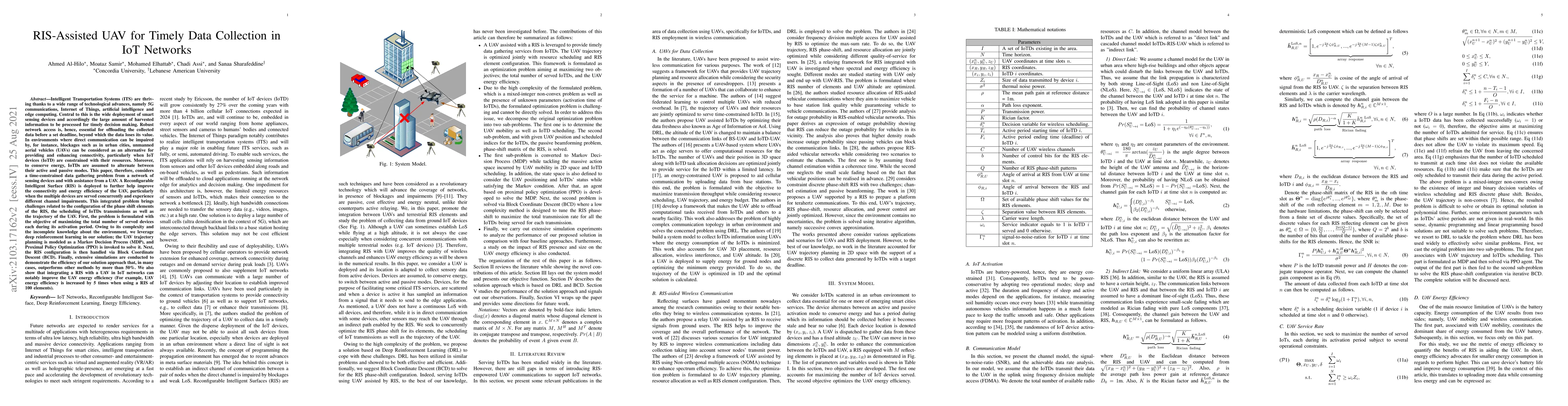
Intelligent Transportation Systems are thriving thanks to a wide range of technological advances, namely 5G communications, Internet of Things, artificial intelligence and edge computing. Central to this is the wide deployment of smart sensing devices and accordingly the large amount of harvested information to be processed for timely decision making. Robust network access is, hence, essential for offloading the collected data before a set deadline, beyond which the data loses its value. In environments where direct communication can be impaired by, for instance, blockages such as in urban cities, unmanned aerial vehicles (UAVs) can be considered as an alternative for providing and enhancing connectivity, particularly when IoT devices (IoTD) are constrained with their resources. Also, to conserve energy, IoTDs are assumed to alternate between their active and passive modes. This paper, therefore, considers a time-constrained data gathering problem from a network of sensing devices and with assistance from a UAV. A Reconfigurable Intelligent Surface (RIS) is deployed to further improve both the connectivity and energy efficiency of the UAV, particularly when multiple devices are served concurrently and experience different channel impairments. This integrated problem brings challenges related to the configuration of the phase shift elements of the RIS, the scheduling of IoTDs transmissions as well as the trajectory of the UAV. First, the problem is formulated with the objective of maximizing the total number of served devices each during its activation period. Owing to its complexity and the incomplete knowledge about the environment, we leverage deep reinforcement learning in our solution; the UAV trajectory planning is modeled as a Markov Decision Process, and Proximal Policy Optimization is invoked to solve it. Next, the RIS configuration is then handled via Block Coordinate Descent.
AI Key Findings
Get AI-generated insights about this paper's methodology, results, significance, and more — seven facets brought into focus.
Impact
Paper Details
Authors
PDF Preview
Key Terms
Citation Network
Current paper (gray), citations (green), references (blue)
Display is limited for performance on very large graphs.
Discussion 0