Quick Summary:

This approach enables faster response times to changes in the road network, while minimizing trajectory matching errors caused by both automatic mapping and human annotation.

Summary

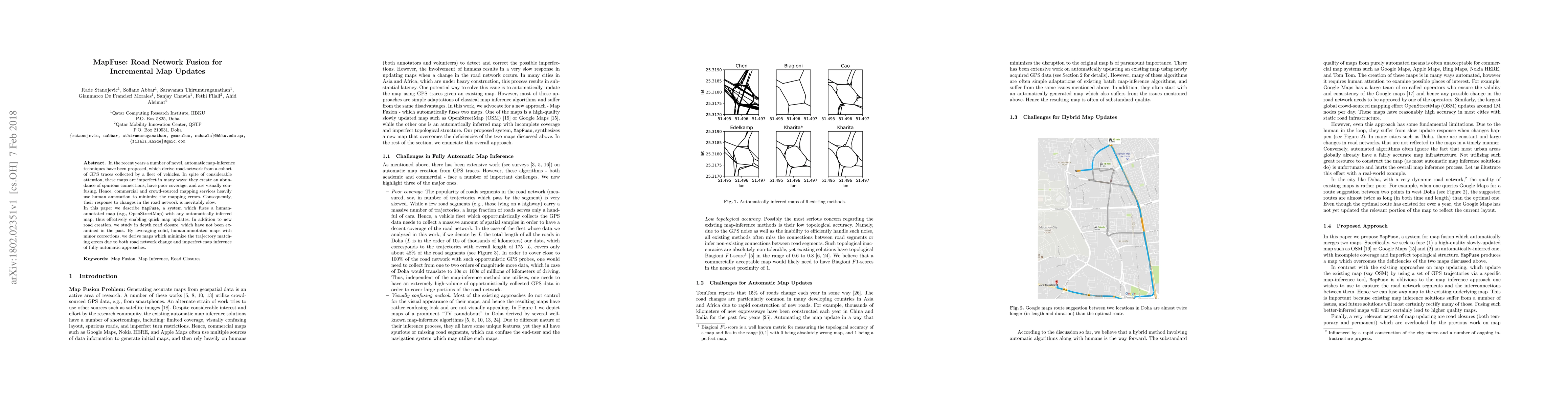
In the recent years a number of novel, automatic map-inference techniques have been proposed, which derive road-network from a cohort of GPS traces collected by a fleet of vehicles. In spite of considerable attention, these maps are imperfect in many ways: they create an abundance of spurious connections, have poor coverage, and are visually confusing. Hence, commercial and crowd-sourced mapping services heavily use human annotation to minimize the mapping errors. Consequently, their response to changes in the road network is inevitably slow. In this paper we describe \mapfuse, a system which fuses a human-annotated map (e.g., OpenStreetMap) with any automatically inferred map, thus effectively enabling quick map updates. In addition to new road creation, we study in depth road closure, which have not been examined in the past. By leveraging solid, human-annotated maps with minor corrections, we derive maps which minimize the trajectory matching errors due to both road network change and imperfect map inference of fully-automatic approaches.

AI Key Findings

Get AI-generated insights about this paper's methodology, results, and significance.

Paper Details

PDF Preview

Download PDF

Key Terms

road (0.347)
map (0.255)
map (0.244)
annotated (0.221)
annotated (0.219)
maps (0.210)
maps (0.204)
human (0.203)
minimize (0.199)
minimize (0.198)
human (0.193)
automatic (0.192)
automatic (0.192)
mapping (0.180)
mapping (0.178)
inference (0.175)
errors (0.175)
errors (0.169)
inference (0.161)
network (0.155)

Citation Network

Current paper (gray), citations (green), references (blue)

Current Paper
Citations
References
Click to view
Title Authors Year Actions
Map Stitcher: Graph Sampling-based Map Conflation
Erfan Hosseini Sereshgi, Carola Wenk
2024
View Paper
DualNet-PoiD: A Hybrid Neural Network for Highly Accurate Recognition of POIs on Road Networks in Complex Areas with Urban Terrain
Yongchuan Zhang, Caixia Long, Jiping Liu, Yong Wang, Wei Yang
2024
View Paper
Understanding the Semantics of GPS-based Trajectories for Road Closure Detection
Jiasheng Zhang, Kaiqiang An, Guoping Liu, Xiang Wen, Runbo Hu, Jie Shao
2023
View Paper
RING-Net: road inference from GPS trajectories using a deep segmentation network
E. Eftelioglu, Ravi Garg, Vaibhav Kango, Chintan Gohil, Amber Roy Chowdhury
2022
View Paper
RoadNote: Automated Road Closure Detection using Urban Sensing
Raiful Hasan, Ragib Hasan
2022
View Paper
Cycling Map Inference Using Global Positioning System Trajectories: A Case Study in the Online Food Delivery Business
Junlin Chen, Wen Jin, Shuiping Chen, Hai Jiang
2022
View Paper
Collective Intelligence during Emergency Egress: The Mechanisms Underlying Altruistic Information Exchange
Hantao Zhao, Tyler Thrash, Fabian Schläfli, M. Kapadia, Leonel Aguilar Melgar, D. Helbing, C. Hölscher
2022
View Paper
Road Closure Detection based upon Multi-feature Fusion
Shengcheng Cai, Tao Wu, Jiali Mao, Cheqing Jin
2021
View Paper
Beyond Road Extraction: A Dataset for Map Update using Aerial Images
F. Bastani, Sam Madden
2021
View Paper
Attributing pedestrian networks with semantic information based on multi-source spatial data
Xue Yang, K. Stewart, Mengyuan Fang, Luliang Tang
2021
View Paper
Urban Map Inference by Pervasive Vehicular Sensing Systems with Complementary Mobility
Zhihan Fang, Guang Wang, Xiaoyan Xie, Fan Zhang, Desheng Zhang
2021
View Paper
Independent Map Enhancement for a Spatial Road Network: Fundamental Applications and Opportunities
Sultan Alamri
2020
View Paper
COLTRANE: ConvolutiOnaL TRAjectory NEtwork for Deep Map Inference
Arian Prabowo, Piotr Koniusz, Wei Shao, Flora D. Salim
2019
View Paper
Trajectories know where map is wrong: an iterative framework for map-trajectory co-optimisation
P. Chao, Wen Hua, Xiaofang Zhou
2019
View Paper
Machine-assisted map editing
F. Bastani, Songtao He, Sofiane Abbar, Mohammad Alizadeh, H. Balakrishnan, S. Chawla, S. Madden
2018
View Paper
Machine Learning Assisted High-Definition Map Creation
Jialin Jiao
2018
View Paper
Structural robustness and service reachability in urban settings
Sofiane Abbar, Tahar Zanouda, Javier Borge-Holthoefer
2018
View Paper
QARTA: An ML-based System for Accurate Map Services
Mashaal Musleh, Sofiane Abbar, R. Stanojevic, M. Mokbel
2021
View Paper
Robust Road Map Inference through Network Alignment of Trajectories
R. Stanojevic, Sofiane Abbar, Saravanan Thirumuruganathan, S. Chawla, F. Filali, Ahid Aleimat
2018
View Paper

Comments (0)

This website uses cookies to ensure you get the best experience. Learn more