Robust Place Recognition using an Imaging Lidar

Source: ArXiv

AI Quick Summary

This paper presents a robust, real-time place recognition method using an imaging lidar that combines high-resolution 3D point clouds with ORB feature descriptors for a rotation-invariant approach, validated through visual feature matching and PnP minimization, tested across diverse datasets.

Share: Share on X LinkedIn

Summary

We propose a methodology for robust, real-time place recognition using an imaging lidar, which yields image-quality high-resolution 3D point clouds. Utilizing the intensity readings of an imaging lidar, we project the point cloud and obtain an intensity image. ORB feature descriptors are extracted from the image and encoded into a bag-of-words vector. The vector, used to identify the point cloud, is inserted into a database that is maintained by DBoW for fast place recognition queries. The returned candidate is further validated by matching visual feature descriptors. To reject matching outliers, we apply PnP, which minimizes the reprojection error of visual features' positions in Euclidean space with their correspondences in 2D image space, using RANSAC. Combining the advantages from both camera and lidar-based place recognition approaches, our method is truly rotation-invariant, and can tackle reverse revisiting and upside down revisiting. The proposed method is evaluated on datasets gathered from a variety of platforms over different scales and environments. Our implementation and datasets are available at https://git.io/image-lidar

AI Key Findings

Generated Sep 02, 2025

Methodology

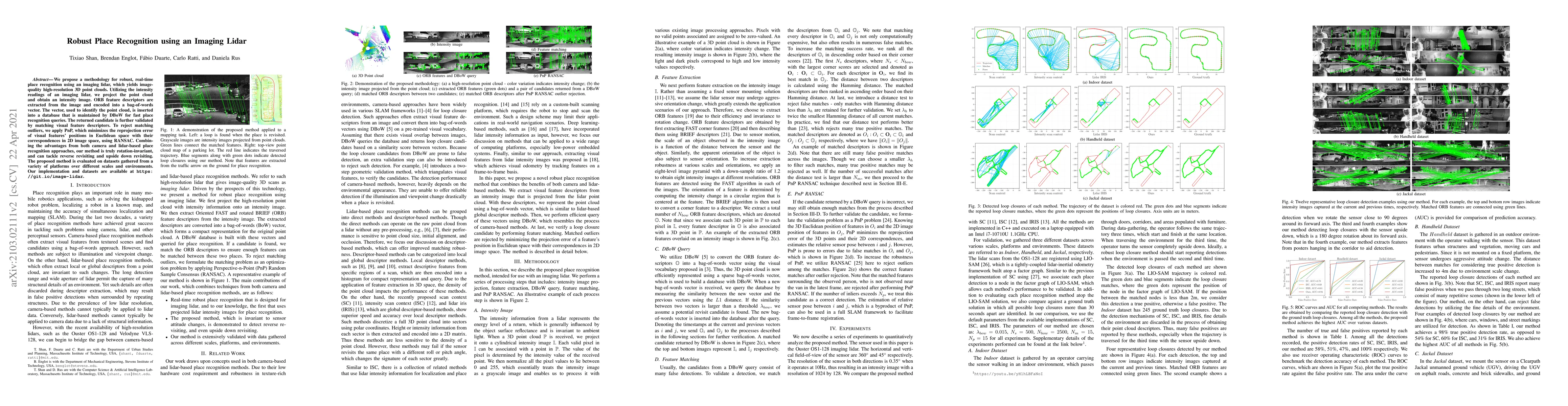
The proposed method utilizes an imaging lidar to generate high-resolution 3D point clouds, from which intensity images are projected. ORB feature descriptors are extracted from these images and encoded into a bag-of-words vector for efficient place recognition queries using DBoW. Candidate loop closures are further validated through feature matching and outlier rejection using PnP-RANSAC, ensuring rotation invariance and handling reverse/upside-down revisits.

Key Results

  • The method combines advantages of both camera and lidar-based approaches, providing robust, real-time place recognition.
  • The approach is rotation-invariant and can handle reverse revisits and upside-down revisits effectively.
  • Evaluated on diverse datasets, the method outperforms existing lidar-based place recognition techniques in terms of accuracy and robustness.
  • The implementation is available for further research and applications.
  • The method is sensitive to lidar resolution, performing best with high-resolution imaging lidars.

Significance

This research presents a novel, robust, and efficient method for place recognition using imaging lidars, which can be crucial for various autonomous navigation systems, such as self-driving cars and robotics, by providing reliable loop closure detection across varying scales, environments, and sensor orientations.

Technical Contribution

The paper introduces a novel method for place recognition using imaging lidars, combining feature extraction from intensity images, bag-of-words representation, and RANSAC-based outlier rejection for robust loop closure detection.

Novelty

This work distinguishes itself by integrating the strengths of both camera-based and lidar-based place recognition methods, offering a rotation-invariant solution that effectively handles reverse and upside-down revisits, while also being sensitive to lidar resolution for optimal performance.

Limitations

  • The method's performance is dependent on the quality and resolution of the lidar sensor.
  • The approach might not generalize well in scenarios with minimal visual overlap or drastic appearance changes.
  • Computational complexity could be a concern for low-power embedded systems.

Future Work

  • Investigate the impact of lidar distortion on place recognition for high-speed platforms.
  • Explore the method's applicability in dynamic environments with moving objects.
  • Optimize the algorithm for real-time performance on low-power embedded systems.

Paper Details

PDF Preview

Download PDF

Key Terms

lidar (0.306)
point cloud (0.229)
image (0.206)
recognition (0.206)
place (0.205)
matching (0.172)
cloud (0.169)
intensity (0.169)

Citation Network

Current paper (gray), citations (green), references (blue)

Display is limited for performance on very large graphs.

Current Paper
Citations
References
Click to view
Title Authors Year Actions

Comments (0)

This website uses cookies to ensure you get the best experience. Learn more