Quick Summary:

This paper proposes using location encoders, including sine-cosine and pre-trained models, to enhance domain adaptation methods for geographic distribution shift. The approach leverages geographic coordinates to improve model robustness, achieving state-of-the-art results on geo-tagged imagery datasets.

Authors:

Summary

Geographic distribution shift arises when the distribution of locations on Earth in a training dataset is different from what is seen at test time. The most common approaches to tackling geographic distribution shift treat regions delimited by administrative boundaries such as countries or continents as separate domains and apply standard domain adaptation methods, ignoring geographic coordinates that are often available as metadata. This paper proposes the use of location encoders for training models that are more robust to geographic distribution shift. We show how both simple sine-cosine encoders and pre-trained location encoders can be used to improve standard domain adaptation methods for the special case of geographic distribution shift. Our proposed methods achieve state-of-the-art results on geo-tagged imagery datasets from the WILDS benchmark.

AI Key Findings

Generated Jun 10, 2025

Methodology

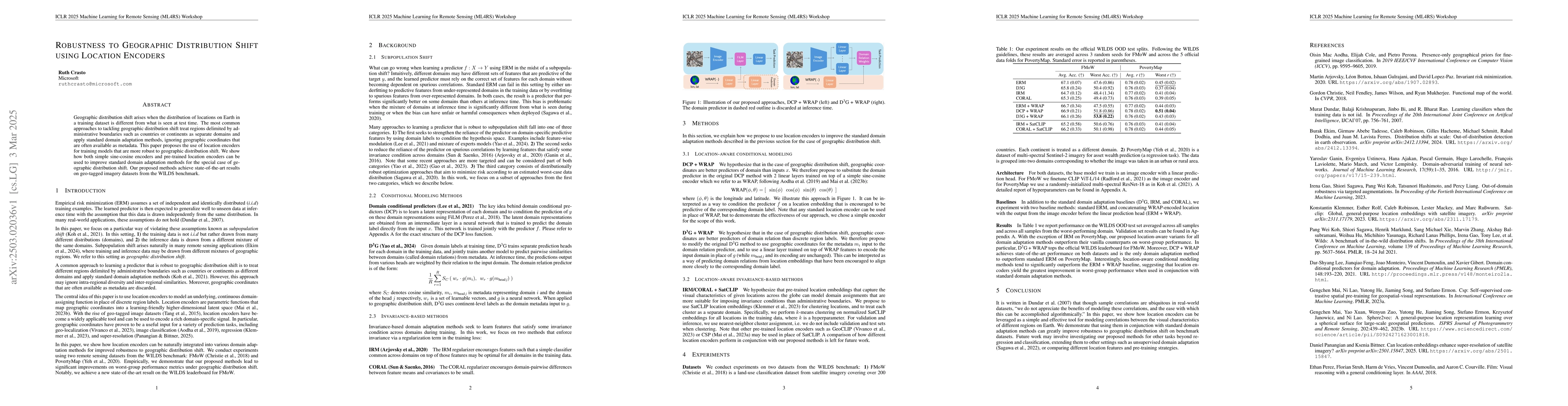
The paper proposes using location encoders to improve robustness to geographic distribution shift, specifically through methods like DCP+WRAP and D3G+WRAP, which leverage geographic coordinates for domain adaptation. Pre-trained location embeddings like SatCLIP are also utilized for clustering locations into domains.

Key Results

  • Proposed methods outperform vanilla counterparts on worst-group performance for both FMoW and PovertyMap datasets.
  • DCP+WRAP tops the official WILDs leaderboard for FMoW, and IRM+SatCLIP achieves state-of-the-art performance on PovertyMap.
  • Location-aware conditional modeling methods significantly outperform the ERM+WRAP baseline, indicating the effectiveness of location encoders in improving robustness.

Significance

This research is significant as it demonstrates the utility of location encoders for modeling correlations between visual characteristics of different Earth regions, enhancing robustness to geographic distribution shifts in benchmark datasets.

Technical Contribution

The paper introduces location-aware conditional modeling (DCP+WRAP, D3G+WRAP) and location-aware invariant-based methods (IRM+SatCLIP, CORAL+SatCLIP) for handling geographic distribution shifts, demonstrating their effectiveness on geo-tagged imagery datasets.

Novelty

The novelty lies in leveraging location encoders, including simple sine-cosine encoders and pre-trained embeddings like SatCLIP, to improve standard domain adaptation methods specifically for geographic distribution shifts, achieving state-of-the-art results on WILDs benchmark datasets.

Limitations

  • The study is limited to specific domain adaptation methods and datasets (FMoW and PovertyMap).
  • Performance on other tasks or datasets beyond regression and classification remains unexplored.

Future Work

  • Investigate the applicability of proposed methods to other tasks such as unsupervised domain adaptation.
  • Compare different location features and pre-training strategies for broader applicability.

Paper Details

PDF Preview

Download PDF

Key Terms

No key terms available for this paper.

No citations found for this paper.

Comments (0)

This website uses cookies to ensure you get the best experience. Learn more