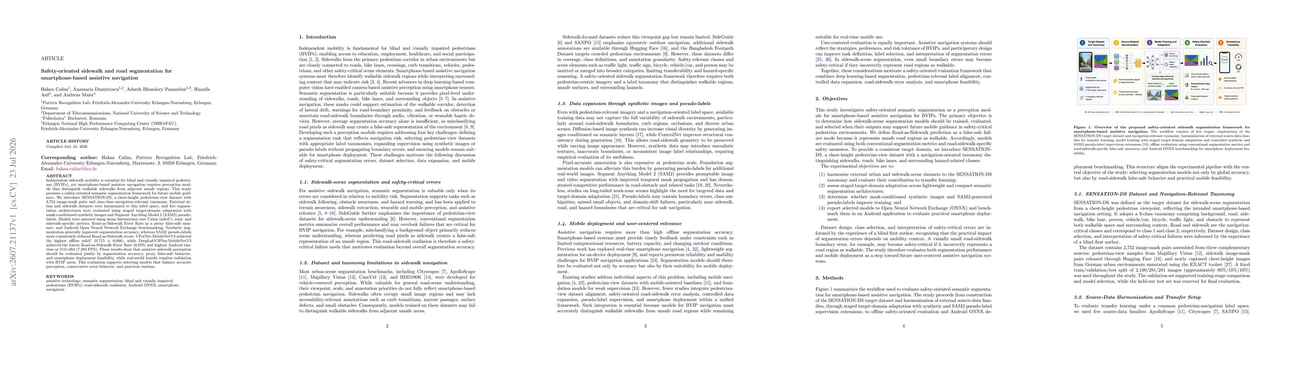
The study evaluates five segmentation architectures on a newly released SENSATION-DS dataset (2,752 image-mask pairs, nine-class taxonomy) using staged target-domain adaptation, mask-conditioned synthetic augmentations, and SAM2 pseudo-labels, with performance assessed via mIoU, road- and sidewalk-specific metrics, Road-as-Sidewalk Error Rate, and ONNX/Android benchmarking.
Safety-oriented sidewalk and road segmentation for smartphone-based assistive navigation
Publication
Metrics
Quick Answers
What methodology did the authors use?
The study evaluates five segmentation architectures on a newly released SENSATION-DS dataset (2,752 image-mask pairs, nine-class taxonomy) using staged target-domain adaptation, mask-conditioned synthetic augmentations, and SAM2 pseudo-labels, with performance assessed via mIoU, road- and sidewalk-specific metrics, Road-as-Sidewalk Error Rate, and ONNX/Android benchmarking. More in Methodology →
What are the key results?
UPerNet-MobileNetV3 achieved the highest offline mIoU of 0.715 ± 0.006. — DeepLabV3Plus-MobileNetV3 achieved the lowest Road-as-Sidewalk Error Rate of 0.079 and the highest Android runtime at 512x384 (7.383 FPS). More in Key Results →
Why is this work significant?
Results demonstrate that safety-critical sidewalk perception requires balancing precise sidewalk/road segmentation, minimization of false-safe misclassifications, and feasible mobile runtime, guiding model selection for assistive navigation systems used by BVIPs. More in Significance →
What are the main limitations?
Evaluation is offline and requires real-world validation with BVIP users to confirm perceived safety benefits. — Nine-class taxonomy may not capture all real-world edge cases or environmental variability across cities. More in Limitations →
Abstract
Independent sidewalk mobility is essential for blind and visually impaired pedestrians (BVIPs), yet smartphone-based assistive navigation requires perception models that distinguish walkable sidewalks from adjacent unsafe regions. This study presents a safety-oriented semantic segmentation framework for future mobile guidance. We introduce SENSATION-DS, a chest-height pedestrian-view dataset with 2,752 image-mask pairs and nine-class navigation-relevant taxonomy. External urban and sidewalk datasets were harmonized to this label space, and five segmentation architectures were evaluated using staged target-domain adaptation with mask-conditioned synthetic images and Segment Anything Model 2 (SAM2) pseudo-labels. Models were assessed using mean Intersection over Union (mIoU), road- and sidewalk-specific metrics, Road-as-Sidewalk Error Rate as a proxy false-safe measure, and Android Open Neural Network Exchange benchmarking. Synthetic augmentation generally improved segmentation accuracy, whereas SAM2 pseudo-labels more consistently reduced Road-as-Sidewalk errors. UPerNet-MobileNetV3 achieved the highest offline mIoU (0.715 +/- 0.006), while DeepLabV3Plus-MobileNetV3 achieved the lowest Road-as-Sidewalk Error Rate (0.079) and highest Android runtime at 512x384 (7.383 FPS). These results show that assistive sidewalk perception should be evaluated jointly by segmentation accuracy, proxy false-safe behavior, and smartphone deployment feasibility, while real-world benefit requires validation with BVIP users. This evaluation supports selecting models that balance accurate perception, conservative error behavior, and practical runtime.
Key Findings, in focus
Seven facets of this paper, analysed and brought into focus by AI.
Results demonstrate that safety-critical sidewalk perception requires balancing precise sidewalk/road segmentation, minimization of false-safe misclassifications, and feasible mobile runtime, guiding model selection for assistive navigation systems used by BVIPs.
- UPerNet-MobileNetV3 achieved the highest offline mIoU of 0.715 ± 0.006.
- DeepLabV3Plus-MobileNetV3 achieved the lowest Road-as-Sidewalk Error Rate of 0.079 and the highest Android runtime at 512x384 (7.383 FPS).
- Synthetic augmentation generally improved segmentation accuracy, while SAM2 pseudo-labels more consistently reduced Road-as-Sidewalk errors.
- Models should be evaluated jointly on segmentation accuracy, conservative error behavior, and smartphone deployment feasibility for real-world BVIP benefit.
Results demonstrate that safety-critical sidewalk perception requires balancing precise sidewalk/road segmentation, minimization of false-safe misclassifications, and feasible mobile runtime, guiding model selection for assistive navigation systems used by BVIPs.
Introduction of SENSATION-DS, a chest-height pedestrian-view dataset with 2,752 image-mask pairs across nine navigation-relevant classes, and a comprehensive evaluation pipeline combining staged target-domain adaptation, synthetic augmentation, and SAM2-based pseudo-label supervision for mobile sidewalk-road segmentation.
First safety-oriented segmentation framework for smartphone-based assistive navigation that explicitly optimizes for true pedestrian safety through Road-as-Sidewalk error metrics, while coupling segmentation performance with mobile deployment feasibility.
- Evaluation is offline and requires real-world validation with BVIP users to confirm perceived safety benefits.
- Nine-class taxonomy may not capture all real-world edge cases or environmental variability across cities.
- Conduct user-in-the-loop studies with BVIP participants to quantify navigation improvements and safety outcomes.
- Explore more diverse domain adaptation strategies and additional efficient architectures for on-device inference.
- Extend the label taxonomy and dataset to include dynamic obstacles and varying lighting conditions.
Discussion 0