Sampling Strategy for Fine-Tuning Segmentation Models to Crisis Area under Scarcity of Data
Publication
Metrics
AI Quick Summary
This research paper proposes a method to guide data collection during fine-tuning of segmentation models in crisis areas with limited data, using prioritization of samples based on predicted IOU scores.
Paper Preview
Abstract
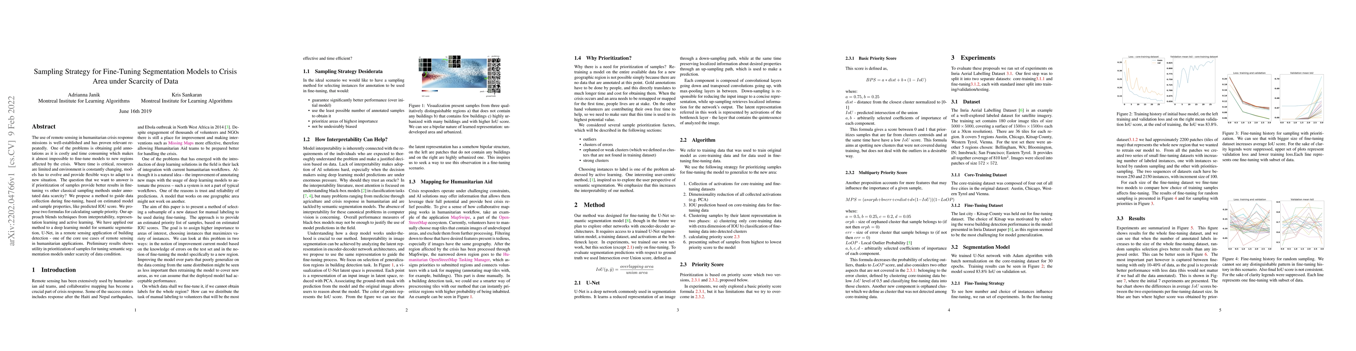
The use of remote sensing in humanitarian crisis response missions is well-established and has proven relevant repeatedly. One of the problems is obtaining gold annotations as it is costly and time consuming which makes it almost impossible to fine-tune models to new regions affected by the crisis. Where time is critical, resources are limited and environment is constantly changing, models has to evolve and provide flexible ways to adapt to a new situation. The question that we want to answer is if prioritization of samples provide better results in fine-tuning vs other classical sampling methods under annotated data scarcity? We propose a method to guide data collection during fine-tuning, based on estimated model and sample properties, like predicted IOU score. We propose two formulas for calculating sample priority. Our approach blends techniques from interpretability, representation learning and active learning. We have applied our method to a deep learning model for semantic segmentation, U-Net, in a remote sensing application of building detection - one of the core use cases of remote sensing in humanitarian applications. Preliminary results shows utility in prioritization of samples for tuning semantic segmentation models under scarcity of data condition.
AI Key Findings
Get AI-generated insights about this paper's methodology, results, significance, and more — seven facets brought into focus.
Impact
Paper Details
Authors
PDF Preview
Key Terms
Citation Network
Current paper (gray), citations (green), references (blue)
Display is limited for performance on very large graphs.
Discussion 0