Summary
Urban scaling laws reveal how cities evolve as their populations grow, yet the role of street network accessibility in this process remains underexplored. We analyze over 5,000 Brazilian cities to establish a scaling law linking average closeness centrality $\langle c_C\rangle$ -- a measure of structural accessibility in street networks-to population size N . Our results demonstrate that $\langle c_C\rangle$ decays sublinearly as $N^{-\sigma}$ ($\sigma \approx 0.38$), indicating that larger cities redistribute accessibility from cores to peripheries while maintaining navigability through hierarchical shortcuts. This scaling arises from the fractal interplay between infrastructure and population, characterized by a network dimension $d \approx 2.17$, which exceeds that of a 2D grid. The slower decline in closeness centrality ($\sigma < 0.5$) reflects a trade-off: urban expansion reduces proximity but enhances connectivity through optimized path diversity, fostering economic dynamism. By integrating the Molinero & Thurner model with network centrality metrics, we provide a framework to reconcile infrastructure efficiency with equitable accessibility in growing cities.
AI Key Findings
Generated Jun 11, 2025
Methodology
The study leverages data from the IBGE API for population estimates and OSMnx Python package for extracting street networks of over 5,000 Brazilian cities, with urban boundaries defined by satellite-derived 2015 urban area data. Each city's road network is modeled as an undirected, weighted spatial graph G={E,V}, where E represents street segments (edges) and V denotes intersections or endpoints (nodes). Nodes are embedded in 2D space via coordinates (x,y), preserving geographic fidelity. For each city, n=|V| and e=|E| define the graph's size and connectivity. Shortest path distances ℓij between nodes i and j underpin key metrics such as farness and closeness centrality.
Key Results
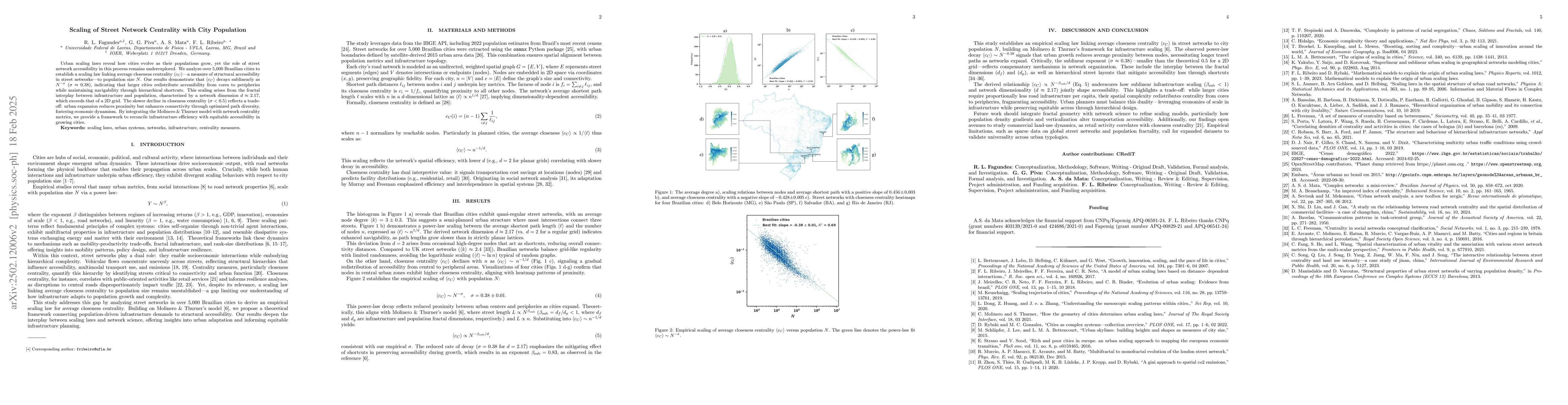
- Brazilian cities exhibit quasi-regular street networks with an average node degree ⟨k⟩=3±0.3, suggesting a semi-planned urban structure where most intersections connect three streets.
- A power-law scaling between the average shortest path length ⟨ℓ⟩ and the number of nodes n, expressed as ⟨ℓ⟩∼n^(1/d), with derived network dimension d≈2.17 (vs. d=2 for a regular grid), indicates enhanced navigability as path lengths grow slower than in strictly planar lattices.
- Closeness centrality ⟨cC⟩ declines with n as ⟨cC⟩∼n^(-1/d), signaling a gradual redistribution of accessibility from central to peripheral areas.
- Empirical scaling of ⟨cC⟩ versus population N establishes ⟨cC⟩∼N^(-σ), σ=0.38±0.01, reflecting reduced proximity between urban centers and peripheries as cities expand.
- The sublinear exponent (σ≈0.38)—smaller than the theoretical 0.5 for a 2D grid—reflects compensatory mechanisms in network organization, including the interplay between the fractal dimensions (df) and (dp) and hierarchical street layouts that mitigate accessibility losses through shortcuts.
Significance
This research is significant as it establishes an empirical scaling law linking average closeness centrality ⟨cC⟩ in street networks to city population N, building on Molinero & Thurner’s framework for infrastructure scaling. The observed power-law decay ⟨cC⟩∼N^(-0.38) signals that urban growth reduces average proximity between nodes, necessitating longer travel paths as networks expand. The sublinear exponent underscores compensatory mechanisms in network organization, highlighting a trade-off between infrastructure efficiency and equitable accessibility in growing cities.
Technical Contribution
The paper presents a framework that reconciles infrastructure efficiency with equitable accessibility in growing cities by integrating the Molinero & Thurner model with network centrality metrics.
Novelty
This work distinguishes itself by analyzing over 5,000 Brazilian cities to establish a scaling law linking street network centrality to population size, revealing a sublinear decay (σ≈0.38) that reflects compensatory mechanisms in urban network organization.
Limitations
- Empirical limitations include sparse data on global street networks and population fractality, calling for expanded datasets to validate universality across urban typologies.
- The study focuses on Brazilian cities, so findings may not be universally applicable to other urban contexts without further investigation.
Future Work
- Integrate fractal geometry with network science to refine scaling models, particularly how population density gradients and verticalization alter transportation accessibility.
- Explore avenues to study commercial land-use dynamics, as retail activity correlates with closeness centrality.
Paper Details
PDF Preview
Citation Network
Current paper (gray), citations (green), references (blue)
Display is limited for performance on very large graphs.
No citations found for this paper.
Comments (0)