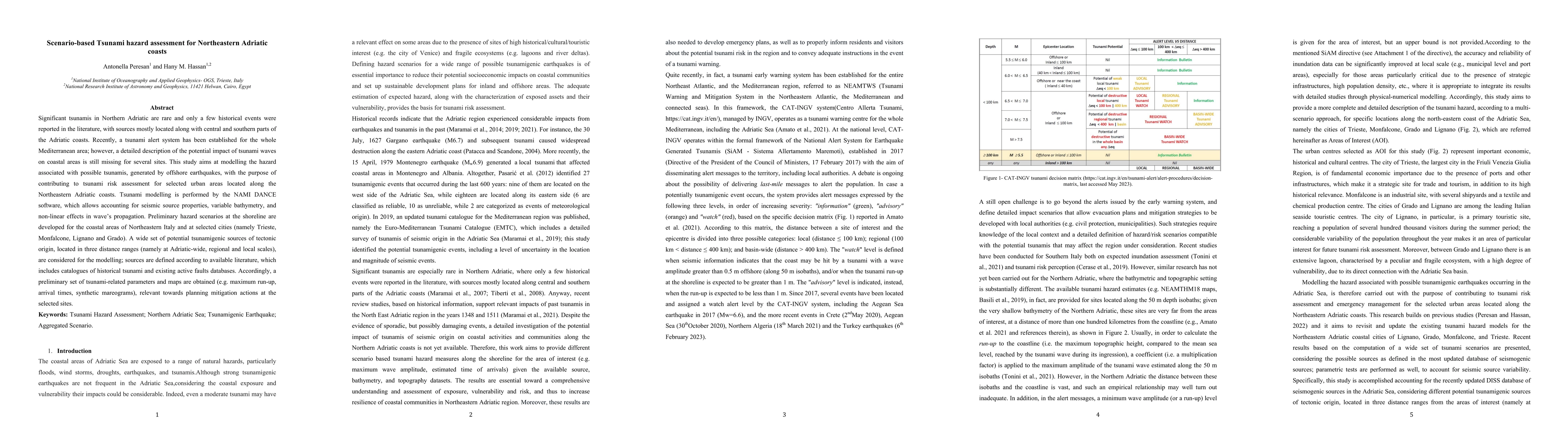
Scenario-based Tsunami hazard assessment for Northeastern Adriatic coasts
Publication
Metrics
AI Quick Summary
This study models the tsunami hazard for Northeastern Adriatic coasts using NAMI DANCE software, focusing on urban areas like Trieste and Monfalcone. It assesses potential tsunami impacts from offshore earthquakes, considering various tsunamigenic sources and providing hazard parameters for risk mitigation planning.
Paper Preview
Abstract
Significant tsunamis in Northern Adriatic are rare and only a few historical events were reported in the literature, with sources mostly located along with central and southern parts of the Adriatic coasts. Recently, a tsunami alert system has been established for the whole Mediterranean area; however, a detailed description of the potential impact of tsunami waves on coastal areas is still missing for several sites. This study aims at modelling the hazard associated with possible tsunamis, generated by offshore earthquakes, with the purpose of contributing to tsunami risk assessment for selected urban areas located along the Northeastern Adriatic coasts. Tsunami modelling is performed by the NAMI DANCE software, which allows accounting for seismic source properties, variable bathymetry, and non-linear effects in waves propagation. Preliminary hazard scenarios at the shoreline are developed for the coastal areas of Northeastern Italy and at selected cities (namely Trieste, Monfalcone, Lignano and Grado). A wide set of potential tsunamigenic sources of tectonic origin, located in three distance ranges (namely at Adriatic-wide, regional and local scales), are considered for the modelling; sources are defined according to available literature, which includes catalogues of historical tsunami and existing active faults databases. Accordingly, a preliminary set of tsunami-related parameters and maps are obtained (e.g. maximum run-up, arrival times, synthetic mareograms), relevant towards planning mitigation actions at the selected sites.
AI Key Findings
Get AI-generated insights about this paper's methodology, results, significance, and more — seven facets brought into focus.
Impact
Paper Details
Authors
PDF Preview
Key Terms
Citation Network
Current paper (gray), citations (green), references (blue)
Display is limited for performance on very large graphs.
Discussion 0