Quick Answers
What methodology did the authors use?
Inverse optimization framework that aligns partial 3D reconstructions to a pseudo‑synthetic reference model rendered from Google Earth Studio, using 3D Gaussian Splatting augmented with DINOv2 semantic features and a robust LTS optimization scheme. More in Methodology →
What are the key results?
Consistently improves global alignment over COLMAP, SP+LG, and gDLS++ baselines across the WikiEarth benchmark. — Outperforms recent feed‑forward 3D reconstruction models (DUSt3R, MASt3R, VGGT, π3) by an order of magnitude in both meta‑to‑meta and meta‑to‑reference settings. More in Key Results →
Why is this work significant?
Provides a scalable, globally consistent alignment solution for large‑scale, non‑overlapping in‑the‑wild imagery, enabling accurate 3D reconstructions where traditional pipelines fail. More in Significance →
What are the main limitations?
Requires a minimum of ~6 images per meta‑image for reliable alignment; performance drops sharply with fewer views. — Sensitive to noisy initial pose estimates and computationally intensive (≈5–15 min per alignment on an A5000 GPU). More in Limitations →
Abstract
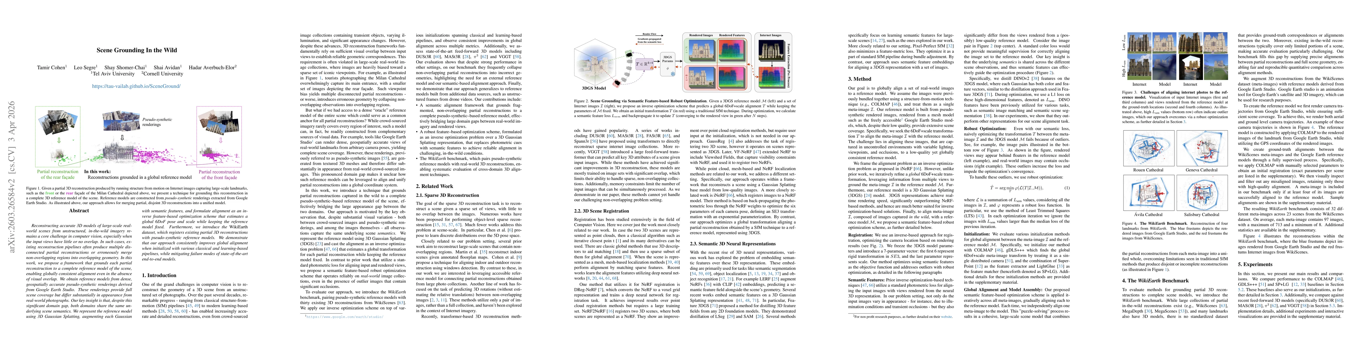
Reconstructing accurate 3D models of large-scale real-world scenes from unstructured, in-the-wild imagery remains a core challenge in computer vision, especially when the input views have little or no overlap. In such cases, existing reconstruction pipelines often produce multiple disconnected partial reconstructions or erroneously merge non-overlapping regions into overlapping geometry. In this work, we propose a framework that grounds each partial reconstruction to a complete reference model of the scene, enabling globally consistent alignment even in the absence of visual overlap. We obtain reference models from dense, geospatially accurate pseudo-synthetic renderings derived from Google Earth Studio. These renderings provide full scene coverage but differ substantially in appearance from real-world photographs. Our key insight is that, despite this significant domain gap, both domains share the same underlying scene semantics. We represent the reference model using 3D Gaussian Splatting, augmenting each Gaussian with semantic features, and formulate alignment as an inverse feature-based optimization scheme that estimates a global 6DoF pose and scale while keeping the reference model fixed. Furthermore, we introduce the WikiEarth dataset, which registers existing partial 3D reconstructions with pseudo-synthetic reference models. We demonstrate that our approach consistently improves global alignment when initialized with various classical and learning-based pipelines, while mitigating failure modes of state-of-the-art end-to-end models. All code and data will be released.
AI Key Findings
Generated Mar 31, 2026
Methodology — What approach did the authors take?
Inverse optimization framework that aligns partial 3D reconstructions to a pseudo‑synthetic reference model rendered from Google Earth Studio, using 3D Gaussian Splatting augmented with DINOv2 semantic features and a robust LTS optimization scheme.
Key Results — What are the main findings?
- Consistently improves global alignment over COLMAP, SP+LG, and gDLS++ baselines across the WikiEarth benchmark.
- Outperforms recent feed‑forward 3D reconstruction models (DUSt3R, MASt3R, VGGT, π3) by an order of magnitude in both meta‑to‑meta and meta‑to‑reference settings.
- Demonstrates generalization to drone‑based reference models and shows that robust LTS filtering stabilizes convergence and reduces outliers.
- Ablation studies confirm that semantic features and LTS are critical for accuracy, while photometric loss and alternative features underperform.
Significance — Why does this research matter?
Provides a scalable, globally consistent alignment solution for large‑scale, non‑overlapping in‑the‑wild imagery, enabling accurate 3D reconstructions where traditional pipelines fail.
Technical Contribution — What is the technical contribution?
An inverse feature‑based optimization method that grounds partial reconstructions to a pseudo‑synthetic reference using 3D Gaussian Splatting with semantic features and a robust LTS scheme.
Novelty — What is new about this work?
First to use large‑scale pseudo‑synthetic renderings as a global reference for grounding, handling domain gaps via semantic features, and providing the WikiEarth benchmark for evaluation.
Limitations — What are the limitations of this study?
- Requires a minimum of ~6 images per meta‑image for reliable alignment; performance drops sharply with fewer views.
- Sensitive to noisy initial pose estimates and computationally intensive (≈5–15 min per alignment on an A5000 GPU).
Future Work — What did the authors propose for future work?
- Train sparse reconstruction pipelines that exploit the aligned meta‑images for improved reconstruction quality.
- Integrate language‑based semantic cues to enable language‑guided scene grounding and navigation.
- Explore hybrid synthetic‑real training to further reduce the domain gap.
Paper Details
How to Cite This Paper
@article{averbuchelor2026scene,
title = {Scene Grounding In the Wild},
author = {Averbuch-Elor, Hadar and Segre, Leo and Avidan, Shai and others},
year = {2026},
eprint = {2603.26584},
archivePrefix = {arXiv},
primaryClass = {cs.CV},
}
Averbuch-Elor, H., Segre, L., Avidan, S., Shomer-Chai, S., & Cohen, T. (2026). Scene Grounding In the Wild. arXiv. https://arxiv.org/abs/2603.26584
Averbuch-Elor, Hadar, et al. "Scene Grounding In the Wild." arXiv, 2026, arxiv.org/abs/2603.26584.
PDF Preview
Similar Papers
Found 4 papersTowards Unified Interactive Visual Grounding in The Wild
Jie Xu, Hanbo Zhang, Qingyi Si et al.
$L^3$:Scene-agnostic Visual Localization in the Wild
Yu Zhang, Muhua Zhu, Yifei Xue et al.
Hand3R: Online 4D Hand-Scene Reconstruction in the Wild
Wendi Hu, Haonan Zhou, Wenhao Hu et al.
Comments (0)