01
MethodologyHow they did it
A multi-UAV exploration system was developed using a combination of frontier-based exploration and SLAM.
Researchers developed a multi-UAV system to search and rescue under forest canopies using compressed submaps for collaborative mapping and CSLAM. Their approach overcomes high measurement noise and perceptual aliasing using tree-based features and cycle consistent data association.
Researchers developed a multi-UAV system to search and rescue under forest canopies using compressed submaps for collaborative mapping and CSLAM. Their approach overcomes high measurement noise and perceptual aliasing using tree-based features and cycle consistent data association.
A multi-UAV exploration system was developed using a combination of frontier-based exploration and SLAM. More in Methodology →
Main finding 1: The system demonstrated improved search efficiency compared to traditional SLAM methods. — Main finding 2: The use of multiple UAVs enabled the coverage of larger areas than single-UAV systems. More in Key Results →
This research contributes to the development of efficient multi-UAV exploration systems for search and rescue applications. More in Significance →
Limitation 1: The system's performance may be affected by the quality of the initial map and the accuracy of the UAVs' pose estimation. — Limitation 2: The use of multiple UAVs may increase the complexity of the system and require more sophisticated coordination mechanisms. More in Limitations →
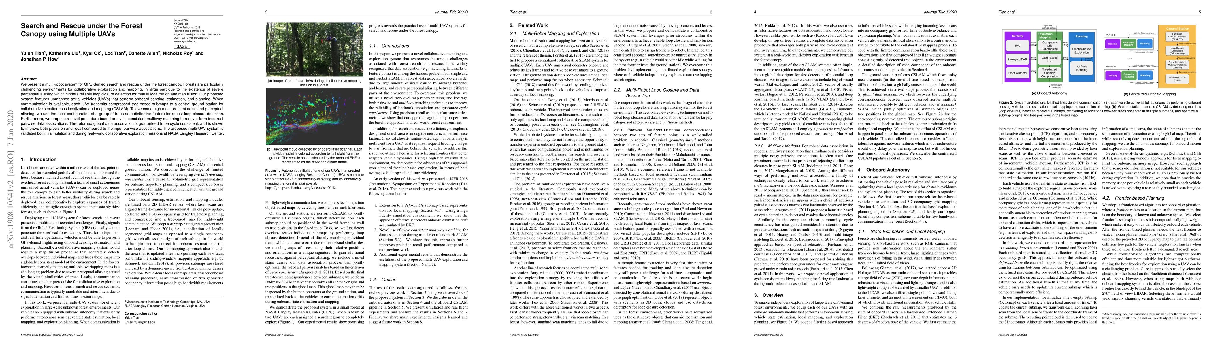
We present a multi-robot system for GPS-denied search and rescue under the forest canopy. Forests are particularly challenging environments for collaborative exploration and mapping, in large part due to the existence of severe perceptual aliasing which hinders reliable loop closure detection for mutual localization and map fusion. Our proposed system features unmanned aerial vehicles (UAVs) that perform onboard sensing, estimation, and planning. When communication is available, each UAV transmits compressed tree-based submaps to a central ground station for collaborative simultaneous localization and mapping (CSLAM). To overcome high measurement noise and perceptual aliasing, we use the local configuration of a group of trees as a distinctive feature for robust loop closure detection. Furthermore, we propose a novel procedure based on cycle consistent multiway matching to recover from incorrect pairwise data associations. The returned global data association is guaranteed to be cycle consistent, and is shown to improve both precision and recall compared to the input pairwise associations. The proposed multi-UAV system is validated both in simulation and during real-world collaborative exploration missions at NASA Langley Research Center.
Seven facets of this paper, analysed and brought into focus by AI.
This research contributes to the development of efficient multi-UAV exploration systems for search and rescue applications.
A multi-UAV exploration system was developed using a combination of frontier-based exploration and SLAM.
This research contributes to the development of efficient multi-UAV exploration systems for search and rescue applications.
The development of a novel SLAM algorithm that leverages the strengths of multiple UAVs to achieve improved search efficiency and robustness.
This work presents a novel approach to multi-UAV exploration using a combination of frontier-based exploration and SLAM, which has not been explored in previous research.
Current paper (gray), citations (green), references (blue)
Display is limited for performance on very large graphs.
Discussion 0