SegDesicNet: Lightweight Semantic Segmentation in Remote Sensing with Geo-Coordinate Embeddings for Domain Adaptation

Source: ArXiv

AI Quick Summary

SegDesicNet introduces a novel unsupervised domain adaptation technique for remote sensing semantic segmentation using geo-coordinate embeddings. The method achieves a ~6% improvement in mean intersection over union (MIoU) while reducing the parameter count by ~27%, demonstrating superior performance compared to state-of-the-art methods.

Share: Share on X LinkedIn

Summary

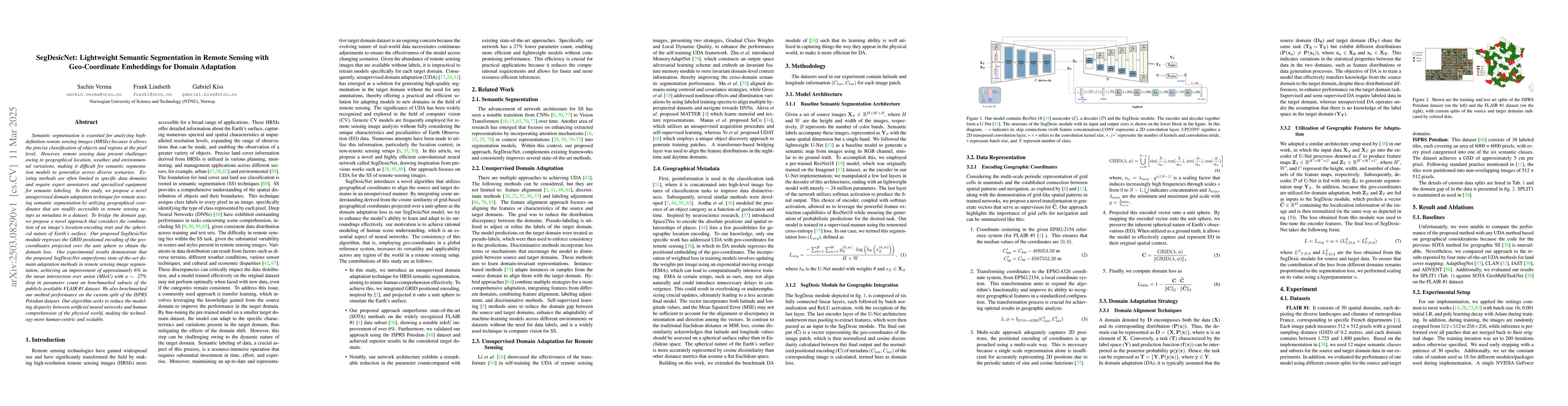
Semantic segmentation is essential for analyzing highdefinition remote sensing images (HRSIs) because it allows the precise classification of objects and regions at the pixel level. However, remote sensing data present challenges owing to geographical location, weather, and environmental variations, making it difficult for semantic segmentation models to generalize across diverse scenarios. Existing methods are often limited to specific data domains and require expert annotators and specialized equipment for semantic labeling. In this study, we propose a novel unsupervised domain adaptation technique for remote sensing semantic segmentation by utilizing geographical coordinates that are readily accessible in remote sensing setups as metadata in a dataset. To bridge the domain gap, we propose a novel approach that considers the combination of an image\'s location encoding trait and the spherical nature of Earth\'s surface. Our proposed SegDesicNet module regresses the GRID positional encoding of the geo coordinates projected over the unit sphere to obtain the domain loss. Our experimental results demonstrate that the proposed SegDesicNet outperforms state of the art domain adaptation methods in remote sensing image segmentation, achieving an improvement of approximately ~6% in the mean intersection over union (MIoU) with a ~ 27\% drop in parameter count on benchmarked subsets of the publicly available FLAIR #1 dataset. We also benchmarked our method performance on the custom split of the ISPRS Potsdam dataset. Our algorithm seeks to reduce the modeling disparity between artificial neural networks and human comprehension of the physical world, making the technology more human centric and scalable.

AI Key Findings

Generated Jun 10, 2025

Methodology

The research proposes a novel unsupervised domain adaptation technique for remote sensing semantic segmentation using geographical coordinates as metadata, bridging the domain gap by considering the image's location encoding and Earth's spherical nature.

Key Results

  • SegDesicNet outperforms state-of-the-art domain adaptation methods in remote sensing image segmentation.
  • Approximately ~6% improvement in mean intersection over union (MIoU) achieved on benchmarked subsets of the FLAIR #1 dataset.
  • A ~27% drop in parameter count while maintaining performance.

Significance

This research aims to reduce the disparity between artificial neural networks and human comprehension of the physical world, making the technology more human-centric and scalable for remote sensing image analysis.

Technical Contribution

The introduction of the SegDesicNet module that regresses GRID positional encoding of geo coordinates projected on a unit sphere for domain loss calculation.

Novelty

The novel use of geo-coordinate embeddings for domain adaptation in semantic segmentation of remote sensing images, distinct from previous methods reliant on specific data domains and expert annotators.

Limitations

  • The paper does not explicitly discuss limitations, but potential limitations could include the reliance on geographical coordinates which may not always be precise or available.
  • Performance was evaluated on specific datasets (FLAIR #1 and ISPRS Potsdam), so generalizability to other datasets remains to be explored.

Future Work

  • Investigate the applicability of the proposed method on additional remote sensing datasets.
  • Explore the incorporation of additional geospatial metadata to further enhance domain adaptation.

Paper Details

PDF Preview

Download PDF

Citation Network

Current paper (gray), citations (green), references (blue)

Display is limited for performance on very large graphs.

Current Paper
Citations
References
Click to view

No citations found for this paper.

Comments (0)

This website uses cookies to ensure you get the best experience. Learn more