Segmentation of arbitrary features in very high resolution remote sensing imagery
Publication
Metrics
AI Quick Summary
This research introduces EcoMapper, a scalable deep learning tool for segmenting arbitrary features in very high resolution remote sensing imagery, aiming to enhance processing efficiency across various geographic regions. The system automates data processing, model training, and inference, and achieves competitive segmentation results in real-world UAV datasets, supported by a newly derived Cording Index for optimal sampling.
Paper Preview
Abstract
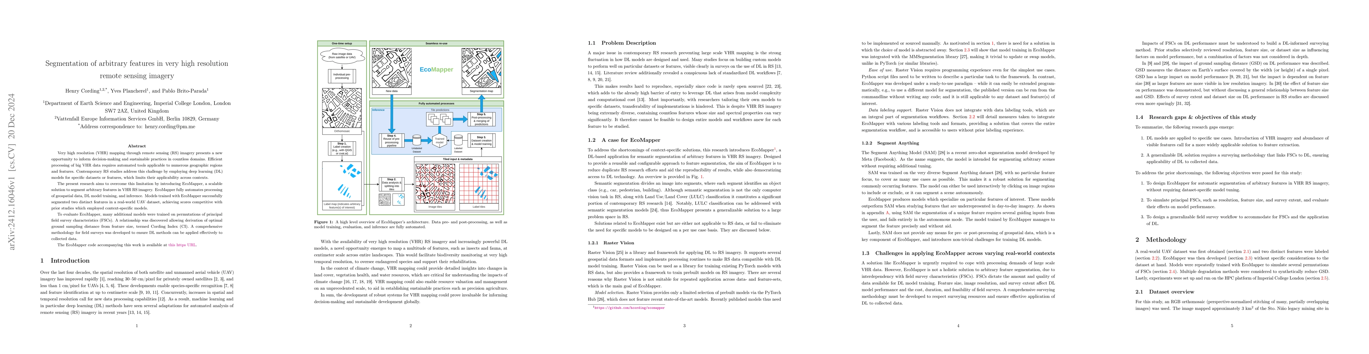
Very high resolution (VHR) mapping through remote sensing (RS) imagery presents a new opportunity to inform decision-making and sustainable practices in countless domains. Efficient processing of big VHR data requires automated tools applicable to numerous geographic regions and features. Contemporary RS studies address this challenge by employing deep learning (DL) models for specific datasets or features, which limits their applicability across contexts. The present research aims to overcome this limitation by introducing EcoMapper, a scalable solution to segment arbitrary features in VHR RS imagery. EcoMapper fully automates processing of geospatial data, DL model training, and inference. Models trained with EcoMapper successfully segmented two distinct features in a real-world UAV dataset, achieving scores competitive with prior studies which employed context-specific models. To evaluate EcoMapper, many additional models were trained on permutations of principal field survey characteristics (FSCs). A relationship was discovered allowing derivation of optimal ground sampling distance from feature size, termed Cording Index (CI). A comprehensive methodology for field surveys was developed to ensure DL methods can be applied effectively to collected data. The EcoMapper code accompanying this work is available at https://github.com/hcording/ecomapper .
AI Key Findings
Get AI-generated insights about this paper's methodology, results, significance, and more — seven facets brought into focus.
Impact
Paper Details
Authors
PDF Preview
Citation Network
Current paper (gray), citations (green), references (blue)
Display is limited for performance on very large graphs.
Discussion 0