Self-Supervised Learning to Guide Scientifically Relevant Categorization of Martian Terrain Images
Publication
Metrics
AI Quick Summary
This paper proposes a self-supervised learning method to automatically categorize Martian terrain images from the Curiosity rover, aiming to create detailed geological categories. The method clusters sedimentary textures and validates the clusters' geologic significance, suggesting its potential for facilitating large-scale Mars terrain recognition datasets.
Paper Preview
Abstract
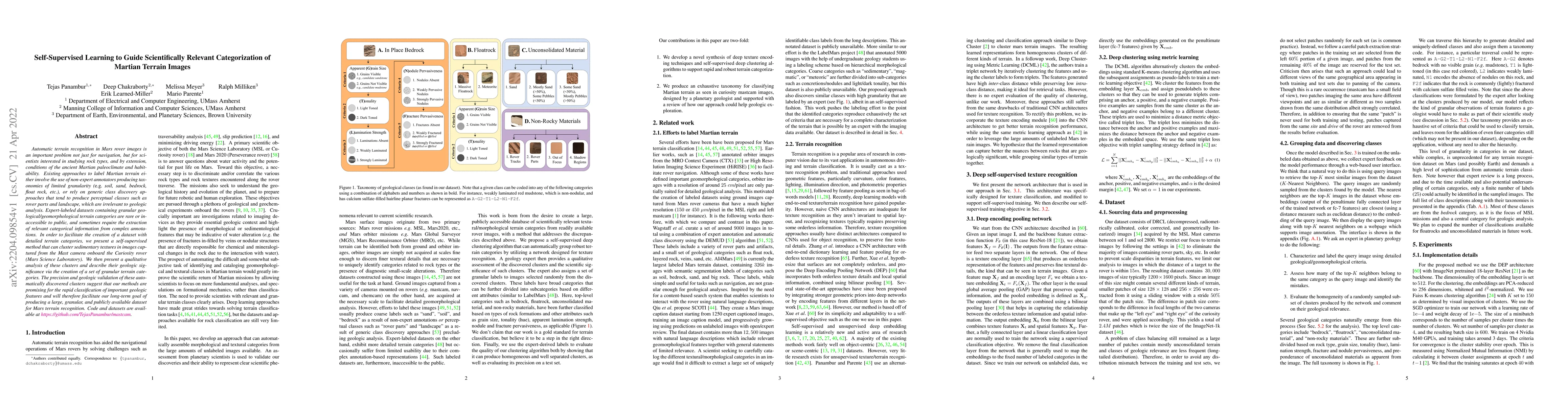
Automatic terrain recognition in Mars rover images is an important problem not just for navigation, but for scientists interested in studying rock types, and by extension, conditions of the ancient Martian paleoclimate and habitability. Existing approaches to label Martian terrain either involve the use of non-expert annotators producing taxonomies of limited granularity (e.g. soil, sand, bedrock, float rock, etc.), or rely on generic class discovery approaches that tend to produce perceptual classes such as rover parts and landscape, which are irrelevant to geologic analysis. Expert-labeled datasets containing granular geological/geomorphological terrain categories are rare or inaccessible to public, and sometimes require the extraction of relevant categorical information from complex annotations. In order to facilitate the creation of a dataset with detailed terrain categories, we present a self-supervised method that can cluster sedimentary textures in images captured from the Mast camera onboard the Curiosity rover (Mars Science Laboratory). We then present a qualitative analysis of these clusters and describe their geologic significance via the creation of a set of granular terrain categories. The precision and geologic validation of these automatically discovered clusters suggest that our methods are promising for the rapid classification of important geologic features and will therefore facilitate our long-term goal of producing a large, granular, and publicly available dataset for Mars terrain recognition.
AI Key Findings
Get AI-generated insights about this paper's methodology, results, significance, and more — seven facets brought into focus.
Impact
Paper Details
Authors
PDF Preview
Key Terms
Citation Network
Current paper (gray), citations (green), references (blue)
Display is limited for performance on very large graphs.
Discussion 0