Self-Supervised Pretraining on Satellite Imagery: a Case Study on Label-Efficient Vehicle Detection
Publication
Metrics
AI Quick Summary
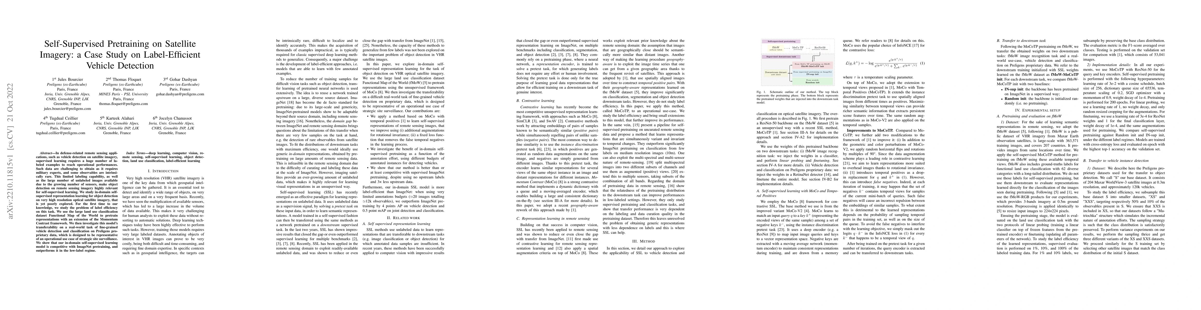
This paper explores self-supervised pretraining on satellite imagery for label-efficient vehicle detection, leveraging the Functional Map of the World dataset. The proposed method outperforms traditional supervised learning in low-label scenarios, demonstrating competitive performance in fine-grained vehicle detection on proprietary Preligens data.
Paper Preview
Abstract
In defense-related remote sensing applications, such as vehicle detection on satellite imagery, supervised learning requires a huge number of labeled examples to reach operational performances. Such data are challenging to obtain as it requires military experts, and some observables are intrinsically rare. This limited labeling capability, as well as the large number of unlabeled images available due to the growing number of sensors, make object detection on remote sensing imagery highly relevant for self-supervised learning. We study in-domain self-supervised representation learning for object detection on very high resolution optical satellite imagery, that is yet poorly explored. For the first time to our knowledge, we study the problem of label efficiency on this task. We use the large land use classification dataset Functional Map of the World to pretrain representations with an extension of the Momentum Contrast framework. We then investigate this model's transferability on a real-world task of fine-grained vehicle detection and classification on Preligens proprietary data, which is designed to be representative of an operational use case of strategic site surveillance. We show that our in-domain self-supervised learning model is competitive with ImageNet pretraining, and outperforms it in the low-label regime.
AI Key Findings
Get AI-generated insights about this paper's methodology, results, significance, and more — seven facets brought into focus.
Impact
Paper Details
Authors
PDF Preview
Key Terms
Citation Network
Current paper (gray), citations (green), references (blue)
Display is limited for performance on very large graphs.
Discussion 0