Authors
Publication
Metrics
Quick Actions
Quick Answers
What methodology did the authors use?
DualComp employs a lightweight, pre‑trained router to split visual tokens into a semantic stream (SCSA) that clusters and prunes background while preserving small objects, and a geometric stream (IGSR) that reconstructs spatial topology via greedy path tracing; the two streams are fused with λ‑weighted concatenation and a topological sequence unrolling before feeding a frozen MLLM. More in Methodology →
What are the key results?
Achieves the highest overall accuracy on XLRS‑Bench (53.10 %) surpassing GeoLLaVA‑8K by 1.6 % and generic baselines; — Reduces visual token volume from ~14k to 6.4k (42.4× compression) and cuts LLM FLOPs from 198 TFLOPs to 99.8 TFLOPs; More in Key Results →
Why is this work significant?
The work demonstrates that task‑aware, dual‑stream token compression can dramatically lower inference cost for ultra‑high‑resolution remote sensing without sacrificing accuracy, enabling practical deployment of large multimodal language models in resource‑constrained settings. More in Significance →
What are the main limitations?
Relies on an offline‑trained, frozen router and frozen CLIP features, limiting adaptability to new domains; — Performance gains on hybrid semantic‑geometric tasks remain modest, indicating residual sensitivity to token allocation. More in Limitations →
Abstract
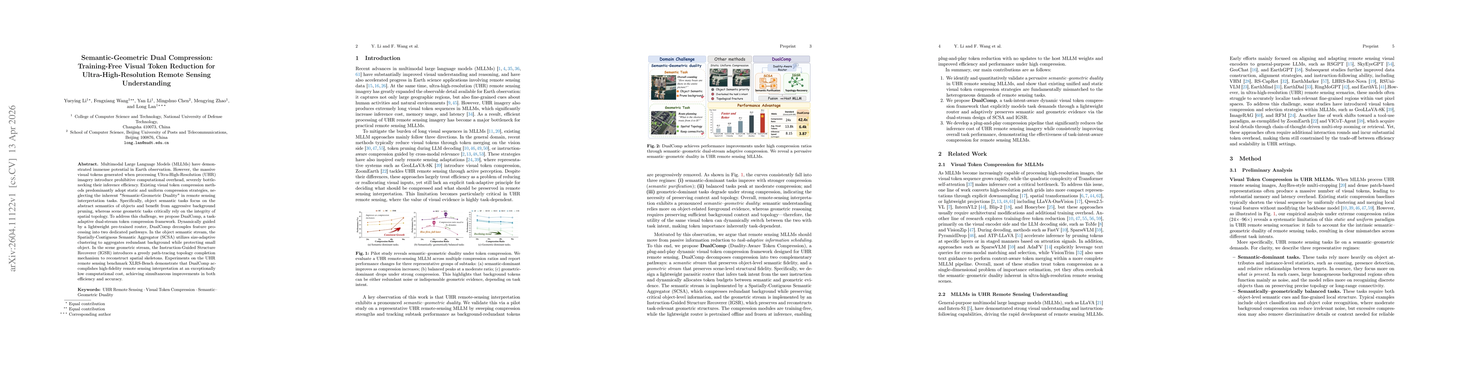
Multimodal Large Language Models (MLLMs) have demonstrated immense potential in Earth observation. However, the massive visual tokens generated when processing Ultra-High-Resolution (UHR) imagery introduce prohibitive computational overhead, severely bottlenecking their inference efficiency. Existing visual token compression methods predominantly adopt static and uniform compression strategies, neglecting the inherent "Semantic-Geometric Duality" in remote sensing interpretation tasks. Specifically, object semantic tasks focus on the abstract semantics of objects and benefit from aggressive background pruning, whereas scene geometric tasks critically rely on the integrity of spatial topology. To address this challenge, we propose DualComp, a task-adaptive dual-stream token compression framework. Dynamically guided by a lightweight pre-trained router, DualComp decouples feature processing into two dedicated pathways. In the object semantic stream, the Spatially-Contiguous Semantic Aggregator (SCSA) utilizes size-adaptive clustering to aggregates redundant background while protecting small object. In the scene geometric stream, the Instruction-Guided Structure Recoverer (IGSR) introduces a greedy path-tracing topology completion mechanism to reconstruct spatial skeletons. Experiments on the UHR remote sensing benchmark XLRS-Bench demonstrate that DualComp accomplishes high-fidelity remote sensing interpretation at an exceptionally low computational cost, achieving simultaneous improvements in both efficiency and accuracy.
AI Key Findings
Generated Apr 14, 2026
Methodology — What approach did the authors take?
DualComp employs a lightweight, pre‑trained router to split visual tokens into a semantic stream (SCSA) that clusters and prunes background while preserving small objects, and a geometric stream (IGSR) that reconstructs spatial topology via greedy path tracing; the two streams are fused with λ‑weighted concatenation and a topological sequence unrolling before feeding a frozen MLLM.
Key Results — What are the main findings?
- Achieves the highest overall accuracy on XLRS‑Bench (53.10 %) surpassing GeoLLaVA‑8K by 1.6 % and generic baselines;
- Reduces visual token volume from ~14k to 6.4k (42.4× compression) and cuts LLM FLOPs from 198 TFLOPs to 99.8 TFLOPs;
- Delivers the fastest end‑to‑end inference (3.87 s/image) while maintaining or improving accuracy compared to VisionZip, FastV, and SparseVLM.
Significance — Why does this research matter?
The work demonstrates that task‑aware, dual‑stream token compression can dramatically lower inference cost for ultra‑high‑resolution remote sensing without sacrificing accuracy, enabling practical deployment of large multimodal language models in resource‑constrained settings.
Technical Contribution — What is the technical contribution?
A plug‑and‑play, training‑free dual‑stream token compression framework that decouples semantic aggregation and geometric topology recovery, guided by a lightweight router and λ‑weighted fusion.
Novelty — What is new about this work?
First to exploit the semantic‑geometric duality of remote sensing tasks with a task‑aware, dual‑stream compression scheme that achieves aggressive compression and accuracy gains without any additional learnable parameters.
Limitations — What are the limitations of this study?
- Relies on an offline‑trained, frozen router and frozen CLIP features, limiting adaptability to new domains;
- Performance gains on hybrid semantic‑geometric tasks remain modest, indicating residual sensitivity to token allocation.
Future Work — What did the authors propose for future work?
- Extend DualComp to other multimodal domains (e.g., medical imaging, autonomous driving) to test generality;
- Develop a learnable, adaptive router that can adjust λ and ρ online for dynamic task preferences.
How to Cite This Paper
@article{wang2026semantic,
title = {Semantic-Geometric Dual Compression: Training-Free Visual Token Reduction for Ultra-High-Resolution Remote Sensing Understanding},
author = {Wang, Fengxiang and Lan, Long and Zhao, Mengying and others},
year = {2026},
eprint = {2604.11122},
archivePrefix = {arXiv},
primaryClass = {cs.CV},
}
Wang, F., Lan, L., Zhao, M., Chen, M., Li, Y., & Li, Y. (2026). Semantic-Geometric Dual Compression: Training-Free Visual Token Reduction for Ultra-High-Resolution Remote Sensing Understanding. arXiv. https://arxiv.org/abs/2604.11122
Wang, Fengxiang, et al. "Semantic-Geometric Dual Compression: Training-Free Visual Token Reduction for Ultra-High-Resolution Remote Sensing Understanding." arXiv, 2026, arxiv.org/abs/2604.11122.
PDF Preview
Similar Papers
Found 4 papersUHR-BAT: Budget-Aware Token Compression Vision-Language model for Ultra-High-Resolution Remote Sensing
Yunkai Dang, Minxin Dai, Yuekun Yang et al.
GeoEyes: On-Demand Visual Focusing for Evidence-Grounded Understanding of Ultra-High-Resolution Remote Sensing Imagery
Fengxiang Wang, Mingshuo Chen, Yueying Li et al.
GeoVista: Visually Grounded Active Perception for Ultra-High-Resolution Remote Sensing Understanding
Jiashun Zhu, Ronghao Fu, Jiasen Hu et al.
Beyond Token Compression: A Training-Free Reduction Framework for Efficient Visual Processing in MLLMs
Hongliang Li, Jiaxin Zhang, Wenhui Liao et al.
Comments (0)