Quick Answers
What methodology did the authors use?
The research proposes a tightly-coupled Semantic-LiDAR-Inertial-Wheel Odometry fusion framework using an improved scan matching algorithm and an Iterative Error-State Kalman Filter (iESKF). It integrates semantic voxel maps with LiDAR, IMU, and wheel odometry data, employing a 3D adaptive scaling strategy for wheel odometry measurement weights. More in Methodology →
What are the key results?
The system outperforms state-of-the-art LiDAR-based localization methods in large-scale dynamic environments. — The semantic voxel map representation significantly reduces long-term trajectory drift by leveraging global semantic information. More in Key Results →
Why is this work significant?
This research addresses critical challenges in autonomous navigation by providing a robust, drift-free localization solution for large-scale dynamic environments, with practical applications in automated ports and logistics. More in Significance →
What are the main limitations?
The system's performance may be affected by extreme environmental conditions or sensor failures. — The reliance on semantic information could introduce computational overhead and complexity. More in Limitations →
Abstract
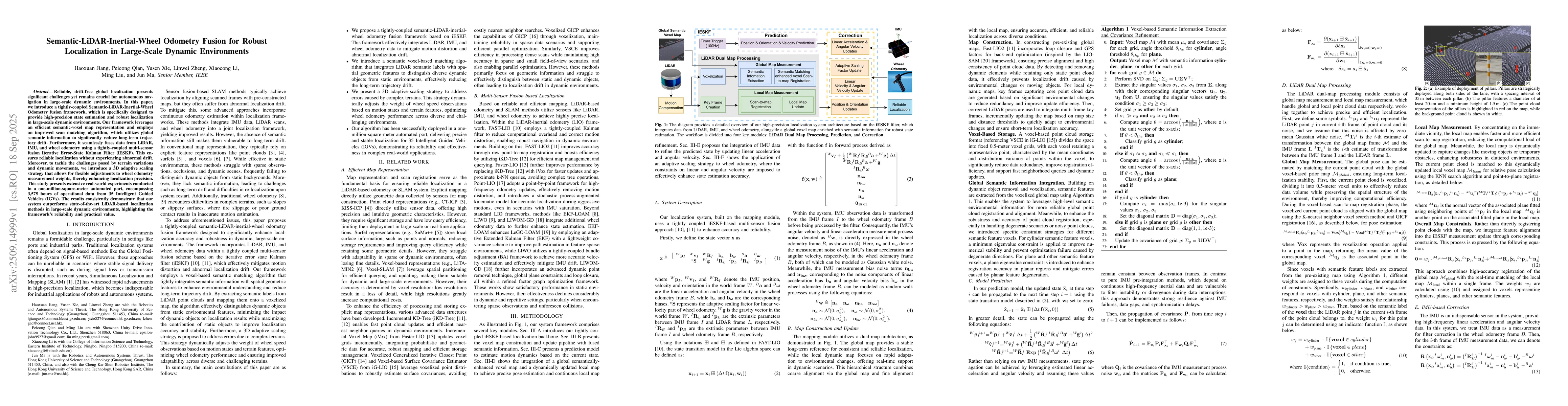
Reliable, drift-free global localization presents significant challenges yet remains crucial for autonomous navigation in large-scale dynamic environments. In this paper, we introduce a tightly-coupled Semantic-LiDAR-Inertial-Wheel Odometry fusion framework, which is specifically designed to provide high-precision state estimation and robust localization in large-scale dynamic environments. Our framework leverages an efficient semantic-voxel map representation and employs an improved scan matching algorithm, which utilizes global semantic information to significantly reduce long-term trajectory drift. Furthermore, it seamlessly fuses data from LiDAR, IMU, and wheel odometry using a tightly-coupled multi-sensor fusion Iterative Error-State Kalman Filter (iESKF). This ensures reliable localization without experiencing abnormal drift. Moreover, to tackle the challenges posed by terrain variations and dynamic movements, we introduce a 3D adaptive scaling strategy that allows for flexible adjustments to wheel odometry measurement weights, thereby enhancing localization precision. This study presents extensive real-world experiments conducted in a one-million-square-meter automated port, encompassing 3,575 hours of operational data from 35 Intelligent Guided Vehicles (IGVs). The results consistently demonstrate that our system outperforms state-of-the-art LiDAR-based localization methods in large-scale dynamic environments, highlighting the framework's reliability and practical value.
AI Key Findings
Generated Sep 30, 2025
Methodology — What approach did the authors take?
The research proposes a tightly-coupled Semantic-LiDAR-Inertial-Wheel Odometry fusion framework using an improved scan matching algorithm and an Iterative Error-State Kalman Filter (iESKF). It integrates semantic voxel maps with LiDAR, IMU, and wheel odometry data, employing a 3D adaptive scaling strategy for wheel odometry measurement weights.
Key Results — What are the main findings?
- The system outperforms state-of-the-art LiDAR-based localization methods in large-scale dynamic environments.
- The semantic voxel map representation significantly reduces long-term trajectory drift by leveraging global semantic information.
- The 3D adaptive scaling strategy enhances localization precision by dynamically adjusting wheel odometry measurement weights.
Significance — Why does this research matter?
This research addresses critical challenges in autonomous navigation by providing a robust, drift-free localization solution for large-scale dynamic environments, with practical applications in automated ports and logistics.
Technical Contribution — What is the technical contribution?
Development of a semantic-voxel map representation combined with an improved scan matching algorithm and a 3D adaptive scaling strategy within a tightly-coupled multi-sensor fusion framework based on iESKF.
Novelty — What is new about this work?
Integration of semantic information with LiDAR, IMU, and wheel odometry data in a unified framework, along with the 3D adaptive scaling strategy for optimized wheel odometry performance on complex terrains.
Limitations — What are the limitations of this study?
- The system's performance may be affected by extreme environmental conditions or sensor failures.
- The reliance on semantic information could introduce computational overhead and complexity.
Future Work — What did the authors propose for future work?
- Expanding semantic element detection to support objects with distinctive geometric shapes.
- Incorporating visual semantic information to further enrich the semantic content of the map.
- Enhancing performance in texture-sparse scenarios through advanced feature extraction techniques.
How to Cite This Paper
@article{jiang2025semantic,
title = {Semantic-LiDAR-Inertial-Wheel Odometry Fusion for Robust Localization in
Large-Scale Dynamic Environments},
author = {Jiang, Haoxuan and Ma, Jun and Zheng, Linwei and others},
year = {2025},
eprint = {2509.14999},
archivePrefix = {arXiv},
primaryClass = {cs.RO},
}
Jiang, H., Ma, J., Zheng, L., Liu, M., Qian, P., Li, X., & Xie, Y. (2025). Semantic-LiDAR-Inertial-Wheel Odometry Fusion for Robust Localization in
Large-Scale Dynamic Environments. arXiv. https://arxiv.org/abs/2509.14999
Jiang, Haoxuan, et al. "Semantic-LiDAR-Inertial-Wheel Odometry Fusion for Robust Localization in
Large-Scale Dynamic Environments." arXiv, 2025, arxiv.org/abs/2509.14999.
PDF Preview
Similar Papers
Found 4 papersAF-RLIO: Adaptive Fusion of Radar-LiDAR-Inertial Information for Robust Odometry in Challenging Environments
Chenglong Qian, Yang Xu, Xiufang Shi et al.
AdaLIO: Robust Adaptive LiDAR-Inertial Odometry in Degenerate Indoor Environments
Hyungtae Lim, Daebeom Kim, Beomsoo Kim et al.
PG-LIO: Photometric-Geometric fusion for Robust LiDAR-Inertial Odometry
Nikhil Khedekar, Kostas Alexis
Comments (0)