Semantically-Enriched Search Engine for Geoportals: A Case Study with ArcGIS Online
Publication
Metrics
AI Quick Summary
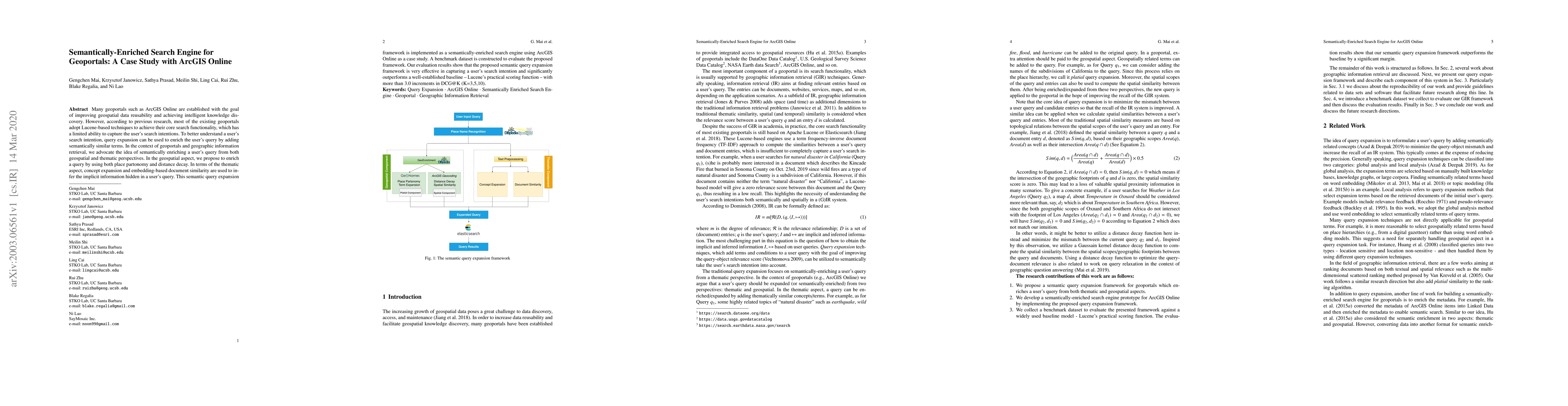
This paper proposes a semantically-enriched search engine for geoportals, specifically implemented in ArcGIS Online, to improve the understanding of user search intentions through query expansion. The framework uses place partonomy, distance decay, concept expansion, and embedding-based document similarity to capture both geospatial and thematic aspects of queries, significantly outperforming traditional Lucene-based search methods.
Paper Preview
Abstract
Many geoportals such as ArcGIS Online are established with the goal of improving geospatial data reusability and achieving intelligent knowledge discovery. However, according to previous research, most of the existing geoportals adopt Lucene-based techniques to achieve their core search functionality, which has a limited ability to capture the user's search intentions. To better understand a user's search intention, query expansion can be used to enrich the user's query by adding semantically similar terms. In the context of geoportals and geographic information retrieval, we advocate the idea of semantically enriching a user's query from both geospatial and thematic perspectives. In the geospatial aspect, we propose to enrich a query by using both place partonomy and distance decay. In terms of the thematic aspect, concept expansion and embedding-based document similarity are used to infer the implicit information hidden in a user's query. This semantic query expansion 1 2 G. Mai et al. framework is implemented as a semantically-enriched search engine using ArcGIS Online as a case study. A benchmark dataset is constructed to evaluate the proposed framework. Our evaluation results show that the proposed semantic query expansion framework is very effective in capturing a user's search intention and significantly outperforms a well-established baseline-Lucene's practical scoring function-with more than 3.0 increments in DCG@K (K=3,5,10).
AI Key Findings
Get AI-generated insights about this paper's methodology, results, significance, and more — seven facets brought into focus.
Impact
Paper Details
Authors
PDF Preview
Key Terms
Citation Network
Current paper (gray), citations (green), references (blue)
Display is limited for performance on very large graphs.
Discussion 0