SG-BEV: Satellite-Guided BEV Fusion for Cross-View Semantic Segmentation
Publication
Metrics
AI Quick Summary
SG-BEV is a novel method for cross-view semantic segmentation using satellite and street-view images, leveraging Bird's Eye View fusion and a satellite-guided reprojection module to enhance feature mapping. It achieves significant improvements, with a 10.13% and 5.21% increase in mIOU compared to state-of-the-art methods across multiple city datasets.
Paper Preview
Abstract
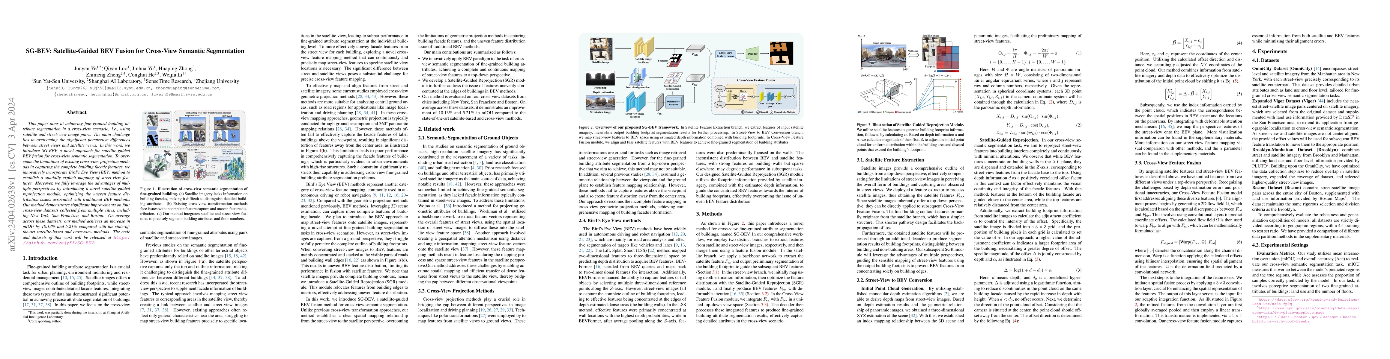
This paper aims at achieving fine-grained building attribute segmentation in a cross-view scenario, i.e., using satellite and street-view image pairs. The main challenge lies in overcoming the significant perspective differences between street views and satellite views. In this work, we introduce SG-BEV, a novel approach for satellite-guided BEV fusion for cross-view semantic segmentation. To overcome the limitations of existing cross-view projection methods in capturing the complete building facade features, we innovatively incorporate Bird's Eye View (BEV) method to establish a spatially explicit mapping of street-view features. Moreover, we fully leverage the advantages of multiple perspectives by introducing a novel satellite-guided reprojection module, optimizing the uneven feature distribution issues associated with traditional BEV methods. Our method demonstrates significant improvements on four cross-view datasets collected from multiple cities, including New York, San Francisco, and Boston. On average across these datasets, our method achieves an increase in mIOU by 10.13% and 5.21% compared with the state-of-the-art satellite-based and cross-view methods. The code and datasets of this work will be released at https://github.com/yejy53/SG-BEV.
AI Key Findings
Get AI-generated insights about this paper's methodology, results, significance, and more — seven facets brought into focus.
Impact
Paper Details
Authors
PDF Preview
Key Terms
Citation Network
Current paper (gray), citations (green), references (blue)
Display is limited for performance on very large graphs.
Discussion 0