The research introduces Sketch and Scale (SnS), a novel framework that uses a Count Sketch data structure to compress data on edge nodes, aggregate reduced sketches on a master node, and run vanilla tSNE or UMAP on the densest areas summary for visualizing high-dimensional data across geographically distributed datasets.
Publication
Metrics
AI Quick Summary
The paper introduces Sketch and Scale (SnS), a novel framework that leverages Count Sketch to compress and aggregate high-dimensional data across geographically distributed datasets, enabling scalable tSNE and UMAP visualizations. The method scales linearly in time and logarithmically in memory and communication, demonstrating its effectiveness on large datasets like cancer and astrophysics data.
Quick Answers
What is "Sketch and Scale: Geo-distributed tSNE and UMAP" about?
The paper introduces Sketch and Scale (SnS), a novel framework that leverages Count Sketch to compress and aggregate high-dimensional data across geographically distributed datasets, enabling scalable tSNE and UMAP visualizations. The method scales linearly in time and logarithmically in memory and communication, demonstrating its effectiveness on large datasets like cancer and astrophysics data.
What methodology did the authors use?
The research introduces Sketch and Scale (SnS), a novel framework that uses a Count Sketch data structure to compress data on edge nodes, aggregate reduced sketches on a master node, and run vanilla tSNE or UMAP on the densest areas summary for visualizing high-dimensional data across geographically distributed datasets. More in Methodology →
What are the key results?
SnS scales linearly in time and logarithmically in memory and communication, enabling analysis of datasets with millions to billions of data points spread across multiple data centers. — The method was successfully demonstrated on two large datasets: 52 million 35-band pixels from cancer data and 100 million stars from the Sloan Digital Sky Survey (SDSS). More in Key Results →
Why is this work significant?
This research is important as it addresses the challenge of visualizing high-dimensional data in a geo-distributed setting while ensuring privacy and data security, which is crucial in today's data management policies. More in Significance →
What are the main limitations?
The paper does not discuss potential pitfalls or limitations of the Count Sketch data structure or SnS framework in detail. — The method's performance with non-uniform data distributions or in the presence of significant noise is not explicitly addressed. More in Limitations →
Abstract
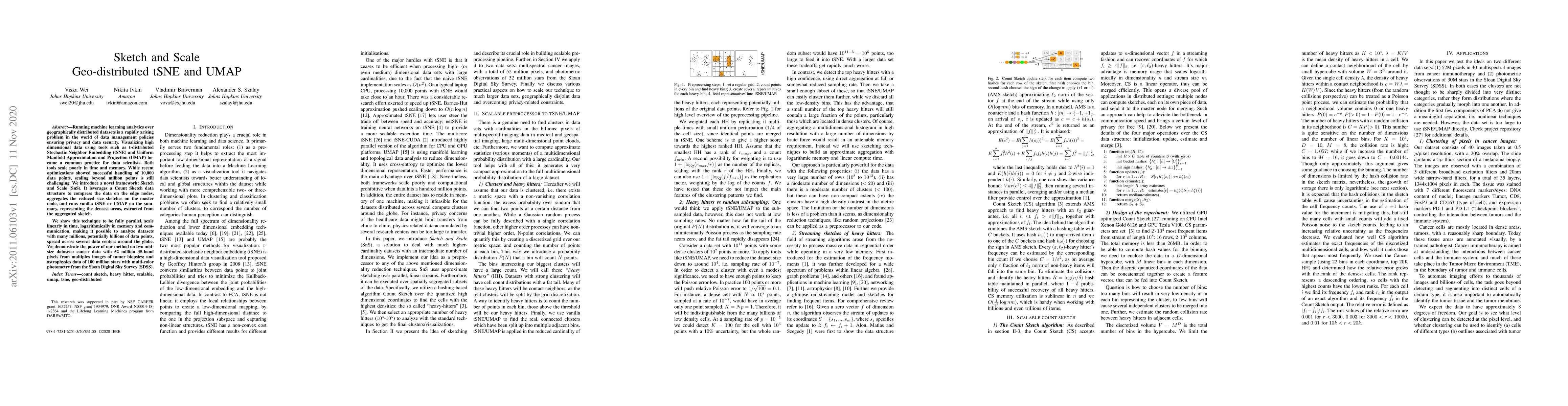
Running machine learning analytics over geographically distributed datasets is a rapidly arising problem in the world of data management policies ensuring privacy and data security. Visualizing high dimensional data using tools such as t-distributed Stochastic Neighbor Embedding (tSNE) and Uniform Manifold Approximation and Projection (UMAP) became common practice for data scientists. Both tools scale poorly in time and memory. While recent optimizations showed successful handling of 10,000 data points, scaling beyond million points is still challenging. We introduce a novel framework: Sketch and Scale (SnS). It leverages a Count Sketch data structure to compress the data on the edge nodes, aggregates the reduced size sketches on the master node, and runs vanilla tSNE or UMAP on the summary, representing the densest areas, extracted from the aggregated sketch. We show this technique to be fully parallel, scale linearly in time, logarithmically in memory, and communication, making it possible to analyze datasets with many millions, potentially billions of data points, spread across several data centers around the globe. We demonstrate the power of our method on two mid-size datasets: cancer data with 52 million 35-band pixels from multiple images of tumor biopsies; and astrophysics data of 100 million stars with multi-color photometry from the Sloan Digital Sky Survey (SDSS).
Key Findings, in focus
Seven facets of this paper, analysed and brought into focus by AI.
This research is important as it addresses the challenge of visualizing high-dimensional data in a geo-distributed setting while ensuring privacy and data security, which is crucial in today's data management policies.
- SnS scales linearly in time and logarithmically in memory and communication, enabling analysis of datasets with millions to billions of data points spread across multiple data centers.
- The method was successfully demonstrated on two large datasets: 52 million 35-band pixels from cancer data and 100 million stars from the Sloan Digital Sky Survey (SDSS).
- SnS correctly sampled clusters in both datasets with different properties, showing excellent agreement with available sparse labels.
This research is important as it addresses the challenge of visualizing high-dimensional data in a geo-distributed setting while ensuring privacy and data security, which is crucial in today's data management policies.
The main technical contribution is the SnS framework, which combines Count Sketch data structure with parallel processing for efficient geo-distributed tSNE and UMAP computations.
SnS introduces a novel approach to scaling tSNE and UMAP for geo-distributed datasets by leveraging data sketching and parallel processing, which differentiates it from existing methods that struggle to handle large-scale datasets.
- The paper does not discuss potential pitfalls or limitations of the Count Sketch data structure or SnS framework in detail.
- The method's performance with non-uniform data distributions or in the presence of significant noise is not explicitly addressed.
- Investigate SnS performance with various data types and distributions.
- Explore the impact of SnS on different dimensionality reduction techniques beyond tSNE and UMAP.
Impact
Paper Details
Authors
PDF Preview
Key Terms
Citation Network
Current paper (gray), citations (green), references (blue)
Display is limited for performance on very large graphs.
Discussion 0