ArxivLens

Publication

Published: Oct 17, 2025
Categories: cs.CV

Metrics

Source: ArXiv

Quick Answers

What methodology did the authors use?

The research employs a satellite-view 3D scene reconstruction approach using a curriculum-based iterative dataset update (IDU) process combined with FlowEdit refinement techniques. It integrates pseudo-depth supervision and opacity regularization to enhance geometric accuracy and texture quality. More in Methodology →

What are the key results?

The method significantly outperforms existing baselines in geometric accuracy and texture quality for low-altitude novel views — Achieves superior performance across diverse urban environments including residential areas, commercial districts, and sports facilities More in Key Results →

Why is this work significant?

This research advances urban scene reconstruction by enabling high-fidelity 3D synthesis from satellite imagery, which has critical applications in urban planning, disaster response, and geographic information systems. More in Significance →

What are the main limitations?

The method requires substantial computational resources (e.g., NVIDIA RTX A6000 GPU) — Performance may degrade with extremely large or complex urban scenes More in Limitations →

Paper Preview

Abstract

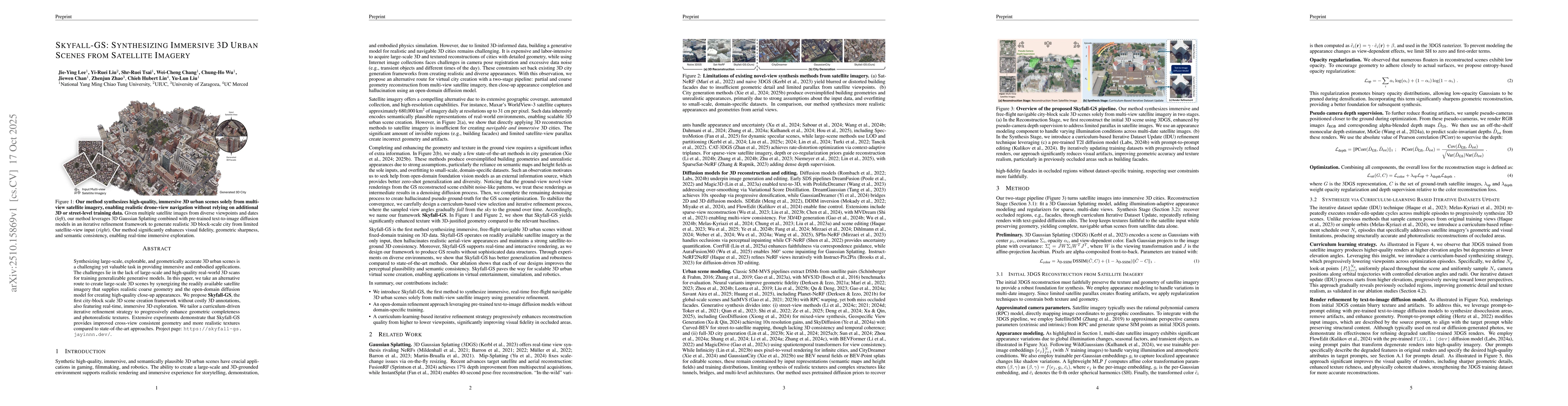
Synthesizing large-scale, explorable, and geometrically accurate 3D urban scenes is a challenging yet valuable task in providing immersive and embodied applications. The challenges lie in the lack of large-scale and high-quality real-world 3D scans for training generalizable generative models. In this paper, we take an alternative route to create large-scale 3D scenes by synergizing the readily available satellite imagery that supplies realistic coarse geometry and the open-domain diffusion model for creating high-quality close-up appearances. We propose \textbf{Skyfall-GS}, the first city-block scale 3D scene creation framework without costly 3D annotations, also featuring real-time, immersive 3D exploration. We tailor a curriculum-driven iterative refinement strategy to progressively enhance geometric completeness and photorealistic textures. Extensive experiments demonstrate that Skyfall-GS provides improved cross-view consistent geometry and more realistic textures compared to state-of-the-art approaches. Project page: https://skyfall-gs.jayinnn.dev/

Key Findings, in focus

Seven facets of this paper, analysed and brought into focus by AI.

AI-generated · verify against source Generated Oct 20, 2025
In focus · one-line synthesis

This research advances urban scene reconstruction by enabling high-fidelity 3D synthesis from satellite imagery, which has critical applications in urban planning, disaster response, and geographic information systems.

01
MethodologyHow they did it

The research employs a satellite-view 3D scene reconstruction approach using a curriculum-based iterative dataset update (IDU) process combined with FlowEdit refinement techniques. It integrates pseudo-depth supervision and opacity regularization to enhance geometric accuracy and texture quality.

02
ResultsWhat they found
  • The method significantly outperforms existing baselines in geometric accuracy and texture quality for low-altitude novel views
  • Achieves superior performance across diverse urban environments including residential areas, commercial districts, and sports facilities
  • Demonstrates effective handling of multi-date satellite imagery variations
03
SignificanceWhy it matters

This research advances urban scene reconstruction by enabling high-fidelity 3D synthesis from satellite imagery, which has critical applications in urban planning, disaster response, and geographic information systems.

04
Technical ContributionsWhat's new technically

Development of a novel satellite-specific 3D reconstruction framework with curriculum-based IDU and FlowEdit refinement, along with pseudo-depth supervision and opacity regularization techniques

05
NoveltyWhat sets it apart

Combines curriculum-based iterative updates with FlowEdit refinement for the first time in satellite-view 3D reconstruction, while introducing satellite-specific regularization techniques for improved geometric fidelity

06
LimitationsWhat to be cautious about
  • The method requires substantial computational resources (e.g., NVIDIA RTX A6000 GPU)
  • Performance may degrade with extremely large or complex urban scenes
07
Future WorkWhere it goes next
  • Exploring real-time synthesis capabilities for satellite imagery processing
  • Investigating integration with drone-based aerial imagery for complementary data sources

Paper Details

Paper ID: 2510.15869
Comments: Project page: https://skyfall-gs.jayinnn.dev/
Categories:
cs.CV

How to Cite This Paper

Reference manager: RIS EndNote


Discussion 0

This website uses cookies to ensure you get the best experience. Learn more