The research introduces SkyLink, a method that combines multi-scale UAV imagery with 3D scene alignment to address cross-view geo-localization challenges. It uses a Google Retrieval Enhancement Module for data augmentation, a Patch-Aware Feature Aggregation module for feature extraction, and a 3D scene bridge module for cross-view alignment through self-supervised and cross-view contrastive learning.
SkyLink: Unifying Street-Satellite Geo-Localization via UAV-Mediated 3D Scene Alignment
Publication
Metrics
Quick Answers
What methodology did the authors use?
The research introduces SkyLink, a method that combines multi-scale UAV imagery with 3D scene alignment to address cross-view geo-localization challenges. It uses a Google Retrieval Enhancement Module for data augmentation, a Patch-Aware Feature Aggregation module for feature extraction, and a 3D scene bridge module for cross-view alignment through self-supervised and cross-view contrastive learning. More in Methodology →
What are the key results?
Achieved 25.75% Recall@1 accuracy on the University-1652 dataset in the UAVM2025 Challenge, outperforming existing methods. — The proposed PAFA module significantly improves feature aggregation and viewpoint robustness, contributing to better cross-view alignment. More in Key Results →
Why is this work significant?
This research advances cross-view geo-localization by effectively bridging the perspective gap between street-level and satellite imagery, with potential applications in urban navigation, autonomous systems, and remote sensing. More in Significance →
What are the main limitations?
The method relies on UAV imagery, which may not be accessible in all scenarios. — The performance may degrade in scenarios with extreme viewpoint disparities or limited visual diversity in street-view data. More in Limitations →
Abstract
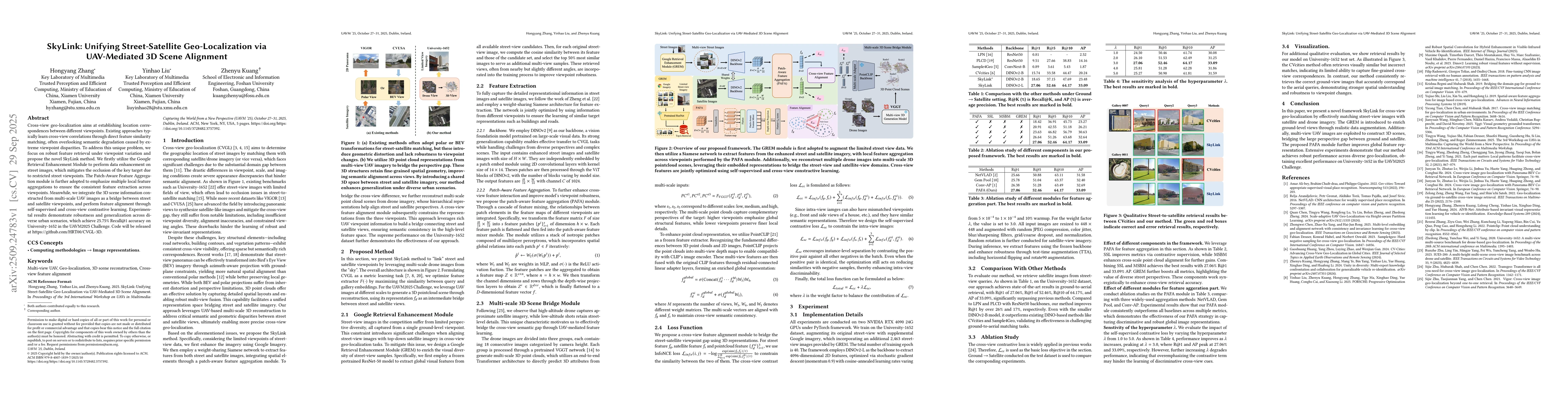
Cross-view geo-localization aims at establishing location correspondences between different viewpoints. Existing approaches typically learn cross-view correlations through direct feature similarity matching, often overlooking semantic degradation caused by extreme viewpoint disparities. To address this unique problem, we focus on robust feature retrieval under viewpoint variation and propose the novel SkyLink method. We firstly utilize the Google Retrieval Enhancement Module to perform data enhancement on street images, which mitigates the occlusion of the key target due to restricted street viewpoints. The Patch-Aware Feature Aggregation module is further adopted to emphasize multiple local feature aggregations to ensure the consistent feature extraction across viewpoints. Meanwhile, we integrate the 3D scene information constructed from multi-scale UAV images as a bridge between street and satellite viewpoints, and perform feature alignment through self-supervised and cross-view contrastive learning. Experimental results demonstrate robustness and generalization across diverse urban scenarios, which achieve 25.75$\%$ Recall@1 accuracy on University-1652 in the UAVM2025 Challenge. Code will be released at https://github.com/HRT00/CVGL-3D.
Key Findings, in focus
Seven facets of this paper, analysed and brought into focus by AI.
This research advances cross-view geo-localization by effectively bridging the perspective gap between street-level and satellite imagery, with potential applications in urban navigation, autonomous systems, and remote sensing.
- Achieved 25.75% Recall@1 accuracy on the University-1652 dataset in the UAVM2025 Challenge, outperforming existing methods.
- The proposed PAFA module significantly improves feature aggregation and viewpoint robustness, contributing to better cross-view alignment.
- The integration of multi-scale 3D point cloud representations from UAV imagery enhances semantic consistency between street and satellite views.
This research advances cross-view geo-localization by effectively bridging the perspective gap between street-level and satellite imagery, with potential applications in urban navigation, autonomous systems, and remote sensing.
The paper introduces a novel framework that combines 3D scene alignment, feature aggregation, and cross-view contrastive learning to achieve robust cross-view geo-localization.
SkyLink uniquely leverages multi-scale UAV-derived 3D point cloud representations as a bridge between street and satellite views, combined with a Patch-Aware Feature Aggregation module to enhance viewpoint robustness and semantic consistency.
- The method relies on UAV imagery, which may not be accessible in all scenarios.
- The performance may degrade in scenarios with extreme viewpoint disparities or limited visual diversity in street-view data.
- Exploring the use of additional sensor data (e.g., LiDAR) to enhance 3D scene representation.
- Investigating the generalization of the method to other types of cross-view geo-localization tasks beyond urban environments.
Discussion 0