Quick Summary:

BlackSky's Smartflow is a cloud-based framework using open-source tools for scalable geospatial data analysis. It processes diverse geospatial data into standardized datacubes, enabling model training and experiment tracking across large areas and time scales, with a novel neural architecture for detecting heavy construction activities.

Summary

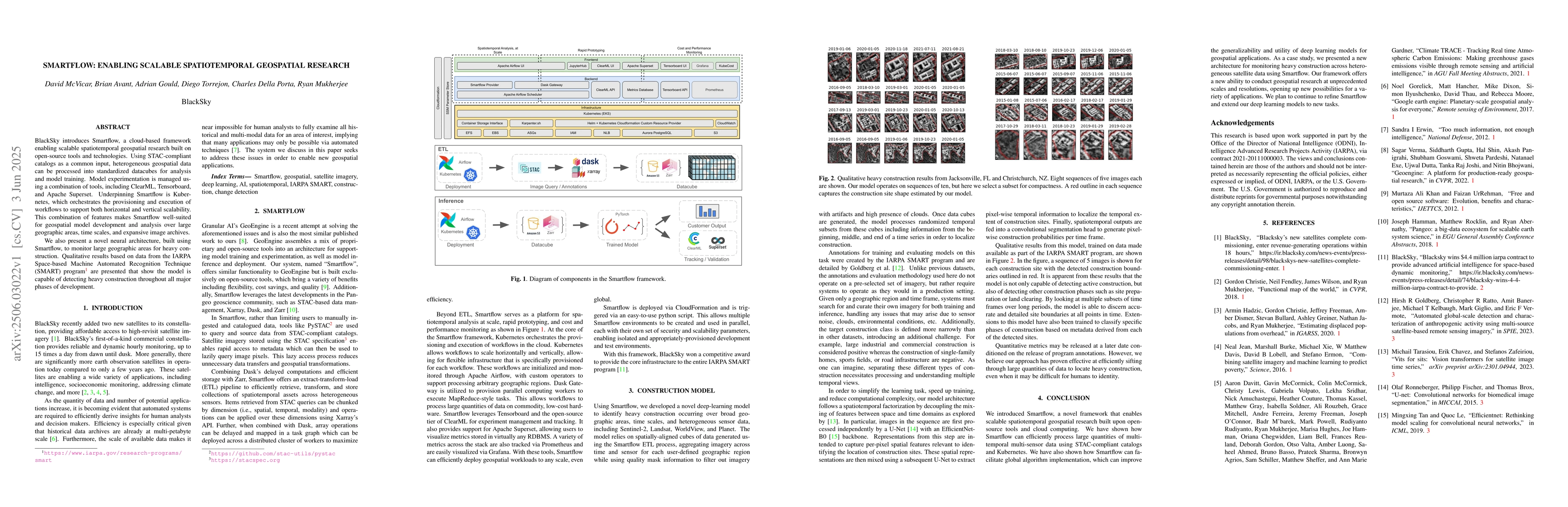
BlackSky introduces Smartflow, a cloud-based framework enabling scalable spatiotemporal geospatial research built on open-source tools and technologies. Using STAC-compliant catalogs as a common input, heterogeneous geospatial data can be processed into standardized datacubes for analysis and model training. Model experimentation is managed using a combination of tools, including ClearML, Tensorboard, and Apache Superset. Underpinning Smartflow is Kubernetes, which orchestrates the provisioning and execution of workflows to support both horizontal and vertical scalability. This combination of features makes Smartflow well-suited for geospatial model development and analysis over large geographic areas, time scales, and expansive image archives. We also present a novel neural architecture, built using Smartflow, to monitor large geographic areas for heavy construction. Qualitative results based on data from the IARPA Space-based Machine Automated Recognition Technique (SMART) program are presented that show the model is capable of detecting heavy construction throughout all major phases of development.

AI Key Findings

Generated Jun 09, 2025

Methodology

Smartflow is a cloud-based framework utilizing open-source tools and technologies, processing heterogeneous geospatial data into standardized datacubes via STAC-compliant catalogs for analysis and model training. It employs Kubernetes for scalable workflow orchestration.

Key Results

  • Smartflow enables scalable spatiotemporal geospatial research over large geographic areas, time scales, and extensive image archives.
  • A novel neural architecture, developed using Smartflow, successfully monitors large geographic areas for heavy construction across all development phases.

Significance

This research is important as it provides a scalable solution for geospatial model development and analysis, which can have significant impacts on industries like construction monitoring, urban planning, and environmental studies.

Technical Contribution

The main technical contribution is the Smartflow framework, which combines open-source tools and Kubernetes for scalable geospatial data processing and model training.

Novelty

Smartflow's novelty lies in its ability to process heterogeneous geospatial data into standardized datacubes using STAC-compliant catalogs, and its application of Kubernetes for scalable workflow orchestration in geospatial research.

Limitations

  • The paper does not explicitly mention any limitations of the Smartflow framework or the neural architecture.
  • Qualitative results are presented based on data from the IARPA SMART program; generalizability to other datasets or scenarios might vary.

Future Work

  • Explore integration with more diverse geospatial datasets to validate the framework's versatility.
  • Investigate potential improvements in the neural architecture for enhanced detection accuracy and reduced computational costs.

Paper Details

PDF Preview

Download PDF

Key Terms

No key terms available for this paper.

Citation Network

Current paper (gray), citations (green), references (blue)

Current Paper
Citations
References
Click to view

Similar Papers

Found 4 papers

SmartFlow: Robotic Process Automation using LLMs

Lovekesh Vig, Shubham Paliwal, Arushi Jain et al.

2024-05-22

Scalable Spatiotemporal Graph Neural Networks

Ivan Marisca, Cesare Alippi, Filippo Maria Bianchi et al.

2023-02-21

Graph Theory Applications in Advanced Geospatial Research

Surajit Ghosh, Archita Mallick, Anuva Chowdhury et al.

2023-10-10

No citations found for this paper.

Comments (0)

This website uses cookies to ensure you get the best experience. Learn more