Quick Summary:

This paper introduces the Wildfire Assessment Model (WAM), a novel deep learning approach combining satellite imagery and atmospheric data to predict wildfire impacts in Spain. The model, pre-trained on unlabelled data and fine-tuned on wildfire samples, significantly improves estimates of resource needs, control time, and expected burnt areas, aiding in better resource allocation and management.

Summary

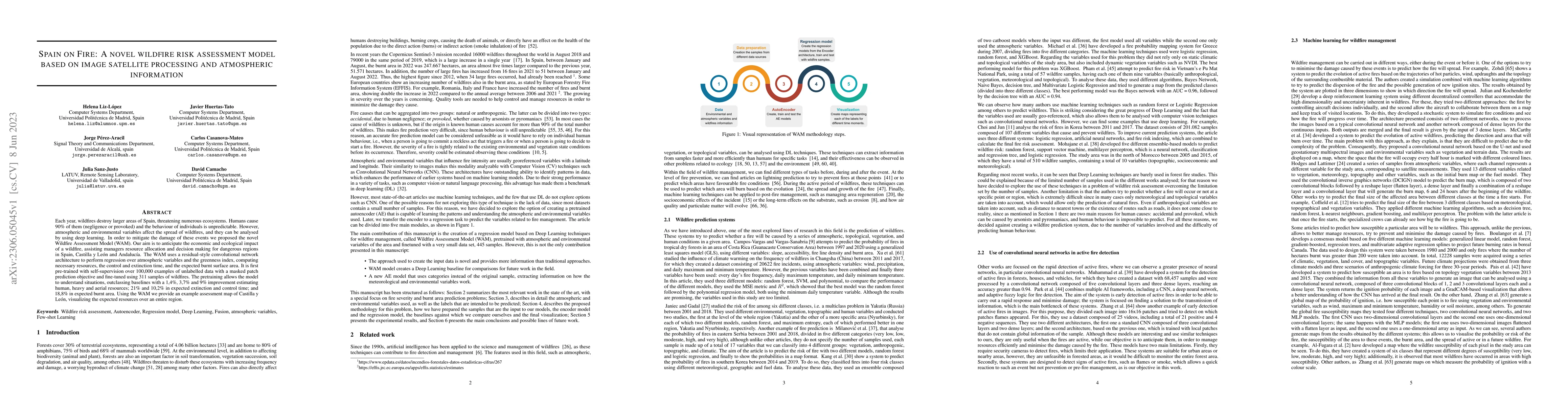
Each year, wildfires destroy larger areas of Spain, threatening numerous ecosystems. Humans cause 90% of them (negligence or provoked) and the behaviour of individuals is unpredictable. However, atmospheric and environmental variables affect the spread of wildfires, and they can be analysed by using deep learning. In order to mitigate the damage of these events we proposed the novel Wildfire Assessment Model (WAM). Our aim is to anticipate the economic and ecological impact of a wildfire, assisting managers resource allocation and decision making for dangerous regions in Spain, Castilla y Le\'on and Andaluc\'ia. The WAM uses a residual-style convolutional network architecture to perform regression over atmospheric variables and the greenness index, computing necessary resources, the control and extinction time, and the expected burnt surface area. It is first pre-trained with self-supervision over 100,000 examples of unlabelled data with a masked patch prediction objective and fine-tuned using 311 samples of wildfires. The pretraining allows the model to understand situations, outclassing baselines with a 1,4%, 3,7% and 9% improvement estimating human, heavy and aerial resources; 21% and 10,2% in expected extinction and control time; and 18,8% in expected burnt area. Using the WAM we provide an example assessment map of Castilla y Le\'on, visualizing the expected resources over an entire region.

AI Key Findings

Get AI-generated insights about this paper's methodology, results, and significance.

Paper Details

PDF Preview

Download PDF

Key Terms

variables (0.147)
regression (0.101)
using (0.093)
impact (0.083)
model (0.072)
proposed (0.057)
order (0.057)
data (0.049)
Title Authors Year Actions
IberFire -- a detailed creation of a spatio-temporal dataset for wildfire risk assessment in Spain
Julen Ercibengoa, Meritxell G'omez-Omella, Izaro Goienetxea
2025
View Paper
Innovative Approaches to Forest Fire Prevention
Syed Shaheer Hassan, Guang Yang, Sana Tahir, Haseeb Ahmad, Muhammad Sabir, Laila Noor, Khuzin Dinislam
2025
View Paper
Wildfire impacts on Spanish municipal population.
Guillermo Peña
2025
View Paper
Wildfire Risk Assessment to Overhead Transmission‐Line Based on Improved Analytic Hierarchy Process
Jun Xu, Chaoying Fang, Yunchu Cheng
2024
View Paper
Machine Learning and Deep Learning for Wildfire Spread Prediction: A Review
Henintsoa S. Andrianarivony, M. Akhloufi
2024
View Paper
On the Integration of Large-Scale Time Series Distance Matrices Into Deep Visual Analytic Tools
Inmaculada Santamaria-Valenzuela, V. Rodríguez-Fernández, David Camacho
2024
View Paper
Climate change and vegetation greening jointly drive the spatial pattern of net radiation variability in northern China
Shuai Wang, Shengwei Zhang, Ying Zhou, Xingyu Zhao, Lin Yang, Ruishen Li, Xi Lin, Meng Luo, Xinghui Chen, Peilin Xing
2024
View Paper
Wildfires impact on PM2.5 concentration in galicia Spain.
César Quishpe-Vásquez, Patricia Oliva, E. López-Barrera, A. Casallas
2024
View Paper
Habitat heterogeneity diversity: A simple animal biodiversity surrogate in Spain
Fábio Suzart de Albuquerque
2024
View Paper
Exploring Multiple Classification Systems for Online Time Series Anomaly Detection
Inmaculada Santamaria-Valenzuela, V. Rodríguez-Fernández, David Camacho
2023
View Paper
Transparency in Medicine: How eXplainable AI is Revolutionizing Patient Care
Helena Liz-López, Javier Huertas-Tato, David Camacho
2023
View Paper

Comments (0)

This website uses cookies to ensure you get the best experience. Learn more