Summary
Road safety management teams utilize on historical accident logs to identify blackspots, which are inherently rare and sparse in space and time. Near-miss events captured through vehicle telematics and transmitted in real-time by connected vehicles reveal a unique potential of prevention due to their high frequency nature and driving engagement on the road. There is currently a lack of understanding of the high potential of near-miss data in real-time to proactively detect potential risky driving areas, in advance of a fatal collision. This paper aims to spatially identify clusters of reported accidents (A) versus high-severity near-misses (High-G) within an urban environment (Sydney, Australia) and showcase how the presence of near-misses can significantly lead to future crashes in identified risky hotspots. First, by utilizing a 400m grid framework, we identify significant crash hotspots using the Getis-Ord $G_i^*$ statistical approach. Second, we employ a Bivariate Local Moran's I (LISA) approach to assess and map the spatial concordance and discordance between official crash counts (A) and High-G counts from nearmiss data (High-G). Third, we classify areas based on their joint spatial patterns into: a) High-High (HH) as the most riskiest areas in both historical logs and nearmiss events, High-Low (HL) for high crash logs but low nearmiss records, c) Low-High (LH) for low past crash records but high nearmiss events, and d) Low-Low (LL) for safe areas. Finally, we run a feature importance ranking on all area patterns by using a contextual Point of Interest (POI) count features and we showcase which factors are the most critical to the occurrence of crash blackspots.
AI Key Findings
Generated Jun 08, 2025
Methodology
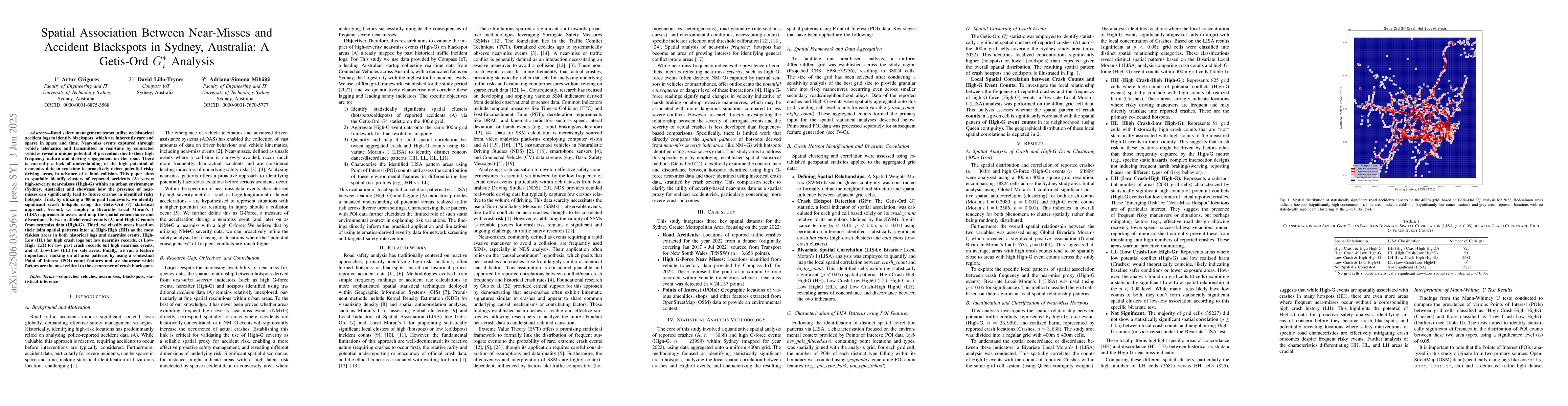
The research employs a 400m grid framework in Sydney, Australia, utilizing the Getis-Ord $G_i^*$ statistical approach to identify crash hotspots. It then applies a Bivariate Local Moran's I (LISA) to assess spatial concordance and discordance between official crash counts (A) and high-severity near-miss data (High-G), classifying areas into HH, HL, LH, and LL categories based on their joint spatial patterns. Feature importance ranking is conducted using contextual Point of Interest (POI) count features.
Key Results
- Significant crash hotspots identified using Getis-Ord $G_i^*$ statistical approach.
- Bivariate Local Moran's I (LISA) reveals spatial concordance and discordance between crash logs and near-miss data.
- Classification of areas into HH (high-risk), HL (high crashes, low near-misses), LH (low crashes, high near-misses), and LL (safe) categories.
- Feature importance ranking highlights critical factors for crash blackspot occurrence.
Significance
This research is important as it demonstrates the potential of near-miss data in proactively detecting risky driving areas, thereby enhancing road safety management by complementing traditional historical accident logs.
Technical Contribution
The application of Getis-Ord $G_i^*$ and Bivariate Local Moran's I (LISA) approaches to spatially analyze near-miss and crash data, combined with feature importance ranking using POI data.
Novelty
This work is novel in its use of high-frequency near-miss data to predict crash blackspots, providing a real-time prevention strategy that complements traditional methods based on historical accident logs.
Limitations
- The study is limited to Sydney, Australia, and may not be generalizable to other urban environments without further investigation.
- Reliance on vehicle telematics data might introduce biases related to equipped vehicle types or driver behavior.
Future Work
- Expand the study to other urban areas to validate findings and generalizability.
- Investigate the impact of varying near-miss data collection methods and vehicle types on the results.
Paper Details
PDF Preview
Citation Network
Current paper (gray), citations (green), references (blue)
Display is limited for performance on very large graphs.
No citations found for this paper.
Comments (0)